
Age:Silurian Type designation:Type section: The Brassfield Limestone was named by Foerste (1906, p. 18, 27) for exposures along the now-abandoned Louisville and Atlantic Railroad between Brassfield and Panola in Madison County, east-central Kentucky (Rexroad, 1986). History of usage:Extended: The Brassfield of Indiana was first called the Clinton Limestone (Foerste, 1896, 1897), a now-abandoned term because the Brassfield of Indiana is continuous with the type Brassfield in east-central Kentucky (Rexroad, 1970).
Description:In Indiana, the Brassfield Limestone is generally a medium- to coarse-grained fossiliferous limestone having numerous irregular blebs and stringers of shale scattered throughout and in many places containing Ordovician pebbles in the lower part (Rexroad, 1970, 1986). Small amounts of fine-grained dolostone are present in most sections, and the Lee Creek Member is also a dolostone (Rexroad, 1986). Color is variable; yellowish brown to salmon pink is common, but near Richmond the basal part is nearly white and the upper part is dark gray and contains scattered yellow grains (Rexroad, 1970, 1986). The formation is generally less than 4 ft (1.2 m) thick along the outcrop belt, but its maximum thickness on outcrop is 14 ft (4.3 m) and in the subsurface is 20 ft (6 m) (Rexroad, 1986).
Boundaries:The Brassfield unconformably overlies the Whitewater Formation of Ordovician age and in turn is unconformably overlain by the Osgood Member of the Salamonie Dolomite or by the undifferentiated Salamonie (Rexroad, 1986).
Correlations:The Brassfield Formation (Rexroad and others, 1965) of the Cincinnati Arch area is time transgressive, the Brassfield Limestone of Indiana being younger than the type Brassfield (Rexroad, 1970, 1986). In Indiana Brassfield conodonts below the Lee Creek belong in the Distomodus kentuckyensis Assemblage Zone of middle and later Llandoverian age; the Lee Creek Member is C5 in age in reference to the standard zonation of the Llandoverian Series of Great Britain (Nicoll and Rexroad, 1968). In some localities evidence is lacking of an unconformity between the Lee Creek and the underlying part of the Brassfield, which suggests that part of the Brassfield proper is as young as the C4 interval in the upper part of the type Llandoverian (Rexroad, 1986). The Indiana Brassfield correlates with the Noland Formation of east-central Kentucky, and the main part of the formation also correlates approximately with the Elwood and Kankakee Formations of northeastern Illinois (Rexroad, 1986). It is continuous with the Sexton Creek Limestone of western Indiana, Illinois, and Missouri and with the Manitoulin and Cabot Head rocks of the Cataract Group (Formation in Indiana) of the Michigan Basin (Rexroad, 1986). Economic Importance:Industrial Minerals: Crushed stone products from the Brassfield Limestone (Silurian) include the following: aglime, crushed stone, fill materials, riprap, rubble, and manufactured sand from quarries in Clark, Decatur, Franklin, Hamilton, Ripley, and Shelby Counties (Shaffer, 2016).
|
|
Regional Indiana usage:
Illinois Basin Margin (COSUNA 12)
Misc/Abandoned Names:Clinton Limestone Geologic Map Unit Designation:Sb Note: Hansen (1991, p. 52) in Suggestions to authors of the reports of the United States Geological Survey noted that letter symbols for map units are considered to be unique to each geologic map and that adjacent maps do not necessarily need to use the same symbols for the same map unit. Therefore, map unit abbreviations in the Indiana Geologic Names Information System should be regarded simply as recommendations. |
COSUNA areas and regional terminologyNames for geologic units vary across Indiana. The Midwestern Basin and Arches Region COSUNA chart (Shaver, 1984) was developed to strategically document such variations in terminology. The geologic map (below left) is derived from this chart and provides an index to the five defined COSUNA regions in Indiana. The regions are generally based on regional bedrock outcrop patterns and major structural features in Indiana. (Click the maps below to view more detailed maps of COSUNA regions and major structural features in Indiana.) 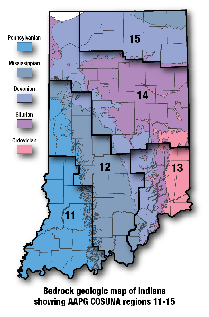
COSUNA areas and numbers that approximate regional bedrock outcrop patterns and major structural features in Indiana. 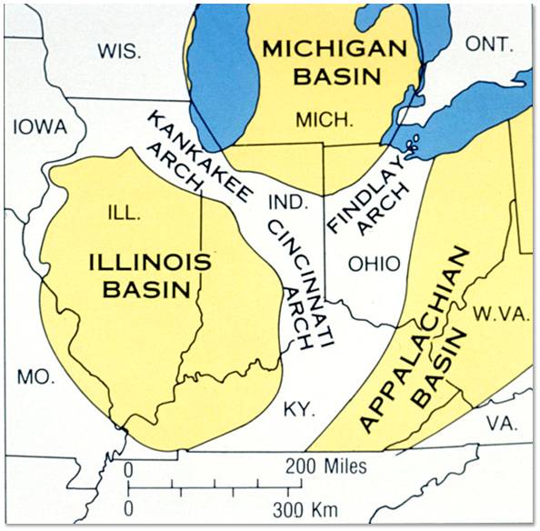
Major tectonic features that affect bedrock geology in Indiana. |
See also:
Cabot Head Member
References:Foerste, A. F., 1896, An account of Middle Silurian rocks of Ohio and Indiana: Cincinnati Society of Natural History Journal, v. 18, p. 161–200. Foerste, A. F., 1897, A report on the geology of the Middle and Upper Silurian rocks of Clark, Jefferson, Ripley, Jennings, and southern Decatur Counties, Indiana: Indiana Department of Geology and Natural Resources Annual Report 21, p. 213–288. Foerste, A. F., 1906, The Silurian, Devonian, and Irvine formations of east-central Kentucky, with an account of their clays and limestones: Kentucky Geological Survey Bulletin 7, 369 p. Hansen, W. R., 1991, Suggestions to authors of the reports of the United States Geological Survey (7th ed.): Washington, D.C., U.S. Geological Survey, 289 p. Rexroad, C. B., Branson, E. R., Smith, M. O., Summerson, Charles, and Boucot, A. J., 1965, The Silurian formations of east-central Kentucky and adjacent Ohio: Kentucky Geological Survey, ser. 10, Bulletin 2, 34 p. Shaver, R. H., coordinator, 1984, Midwestern basin and arches region–correlation of stratigraphic units in North America (COSUNA): American Association of Petroleum Geologists Correlation Chart Series. |
|
For additional information, contact:
Nancy Hasenmueller (hasenmue@indiana.edu)Date last revised: August 13, 2021
