

These and other applications broadly highlight the concept of hydrogeologic framework — how different combinations of geologic, topographic, and hydrologic conditions control the occurrence, abundance, chemistry, and movement of groundwater beneath different geologic terrains. Seemingly subtle differences in the geologic framework can cause groundwater characteristics to vary enormously from place to place, even within the confines of a relatively small area such as Marion County. This Web page presents a primer on the hydrogeologic framework of Marion County, and highlights how differences in hydrogeologic conditions are manifested from place to place, both in terms of meeting human needs as well as in the natural landscape and water bodies of the county.
Water Resources
An abundance of both groundwater and surface-water resources has been instrumental to the historical growth of Marion County as a center
of population and commerce. The City of Indianapolis has long been served by a centralized public water supply that uses a combination of
surface water sources, derived from Eagle Creek, Geist, and Morse Reservoirs (the latter is in Hamilton County), along with several
Most outlying parts of the county, as well as some large industrial and commercial water users within the area served by public water supplies, have traditionally used individual wells to provide groundwater for residential, commercial, and industrial purposes. The construction records from many thousands of such wells, now available online at the Indiana Department of Natural Resources, Division of Water, served as a key source of subsurface information in the preparation of the geologic and hydrogeologic interpretations presented in the original report upon which this Web site is based.
Aquifers, Confining Units, and Aquifer Systems and Complexes
Groundwater is defined as all water below the surface of the Earth. Major sources of groundwater are concentrated in
bodies of
It is clear from these definitions that all the
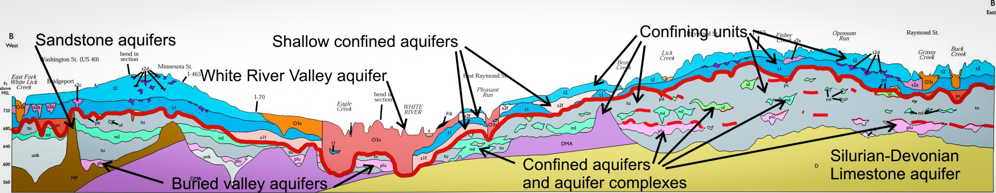
Figure 1.
As illustrated in Figure 1, aquifers occur along a variety of horizons and in many configurations beneath Marion County. They include sand and gravel
bodies throughout the glacial section as well as limestone and sandstone bedrock. The major confining units consist of sequences of
glacial till of
An aquifer system, on the other hand, is defined as "a heterogeneous body of permeable and poorly permeable materials that functions
regionally as a water-yielding unit; it consists of two or more aquifers separated at least locally by confining units that impede
groundwater movement, but do not affect the overall hydraulic continuity of the system" (Poland and others, 1972). Water-level data
available from many water supply wells and groundwater monitoring wells, coupled with the subsurface geologic information regarding
the origin and geometry of aquifers and confining units, indicate that the sand and gravel units along the pre-Wisconsin surface and
within the overlying late Wisconsin sequences collectively form a coherent shallow aquifer system.
Permeable sandstone of the
The shallow aquifer system also includes the large bodies of highly transmissive, saturated surface outwash along the major drainages, whose middle and lower parts are frequently in direct contact with, and thus hydraulically connected to, other aquifers in the shallow system, as well as to several deeper aquifers and aquifer complexes. Although the White River itself is relatively small, its valley overlies a massive complex of sand and gravel (fig. 1) that contains an enormous volume of groundwater. This valley aquifer system is the preeminent source of water for the greater Indianapolis area and supports the preponderance of manufacturing, energy-generation, and other water-intensive activities in the valley.
Other aquifers and aquifer systems are also present at greater depth below the shallow aquifer system. These deeper water-bearing units
include a variety of both large and small sand and gravel bodies as well as transmissive zones within the
Water Table, Potentiometric Surface, and Groundwater Flow Systems
The
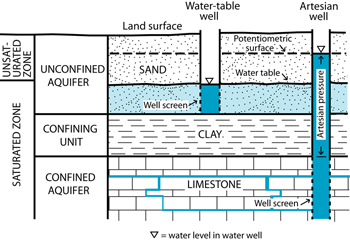
Figure 2.
Relationship between the water table, piezometric surface, and water levels in wells developed in confined and unconfined aquifers.
The water table is present both in aquifers and confining units. Unconfined aquifers are also known as "water table aquifers" because they usually have a significant vadose zone between the land surface (in the upper, unsaturated part of the aquifer) and the water table; the depth of the water table, and thus the thickness of the unsaturated zone, fluctuates seasonally in response to precipitation patterns, groundwater recharge, and water levels in adjacent streams. This relationship highlights the strong connection that is typically present between surface water and groundwater in adjacent aquifers: during periods of flooding, surface water commonly leaks into the adjacent aquifer and raises groundwater levels; whereas in dry periods, the continuous discharge of groundwater from adjacent aquifers maintains the base flow of surface streams. An important implication of this relationship is that the elevation of a surface water body in contact with an unconfined aquifer also represents the elevation of the water table at that location.
On the other hand, it is very common for a shallow water table to be present where glacial till or other fine-grained sediments are at the land surface, because they typically are poorly permeable and retard downward movement of water into underlying aquifers. It might be recalled that most of the central till plain was a wetland prior to settlement and the advent of artificial drainage, so the appearance of a seasonally high water table in the modern landscape (fig. 3) is scarcely surprising, and is simply a reminder of the natural history of the region.
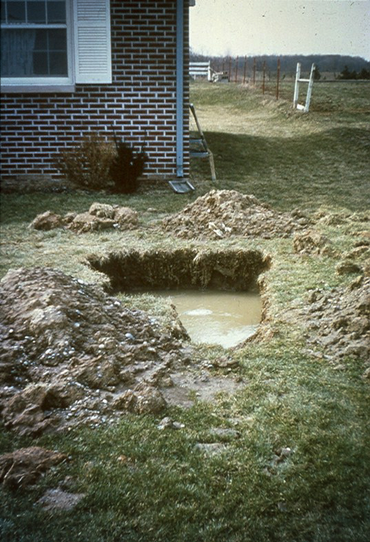
Figure 3.
Perched water table in glacial till,
central Indiana. Photo by A. H. Fleming.
In some cases, a continuous saturated condition may persist downward through the confining unit and into the underlying aquifer. The
water level in such a confined aquifer, when measured in a well, typically will be higher than the top of the aquifer (fig. 2),
reflecting the
In any case, the level to which water rises when measured at any given point in a confined aquifer is referred to as the
Still another common condition occurs when there is sufficient contrast in permeability between a confining unit and the underlying
aquifer to cause water table conditions to exist in both units, that is, the aquifer is not completely saturated and a secondary
vadose zone exists in the upper part of the aquifer below a saturated confining unit. In this situation, the water table in the
confining unit is referred to as a "
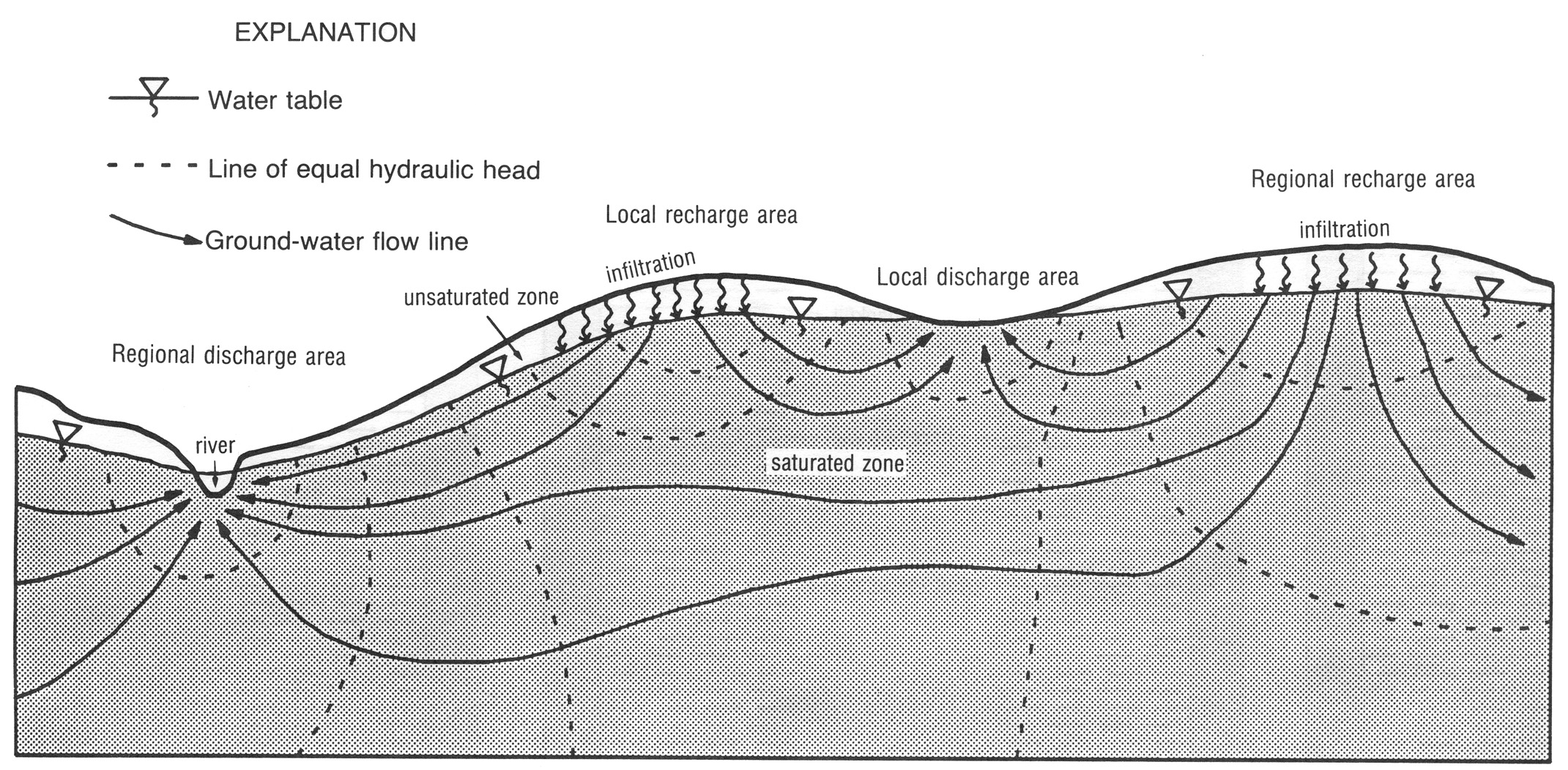
Figure 4.
Schematic diagram illustrating the distribution of hydraulic head, the groundwater flow system, and the distribution of groundwater
recharge and discharge in relation to surface topography for a simple water-table aquifer (from Fleming, 1994).
The preceding discussion calls attention to the fact that groundwater is a dynamic resource that flows from one place to another in the subsurface in response to lateral and vertical differences in hydraulic head. Hydraulic head is a function of pressure and elevation. The former is the predominant driver of hydraulic head differences in confined, artesian aquifers, as reflected by the configuration of the potentiometric surface, whereas the latter is more important in unconfined (water-table) aquifers; however, both components are present in all types of aquifers. Because of this, neither the water table nor the potentiometric surface are flat, rather they are slightly to strongly sloping surfaces whose configurations broadly mimic the topography of the overlying landscape (fig. 4). Regional uplands are underlain by sizable water-table and potentiometric highs, while large valleys coincide with similarly shaped valleys in the water table and potentiometric surfaces of subjacent aquifers. This relationship reflects the fact that most uplands act as groundwater recharge areas — places where precipitation percolates downward through the soil and unsaturated zone and into aquifers — whereas most streams are the recipients of groundwater discharge, whose ongoing leakage to the surface in the form of springs, seeps, and direct discharge in streambeds sustains the base flow of streams throughout the year, especially during extended periods of little to no precipitation.
The slope of the water table or potentiometric surface makes up the horizontal component of the
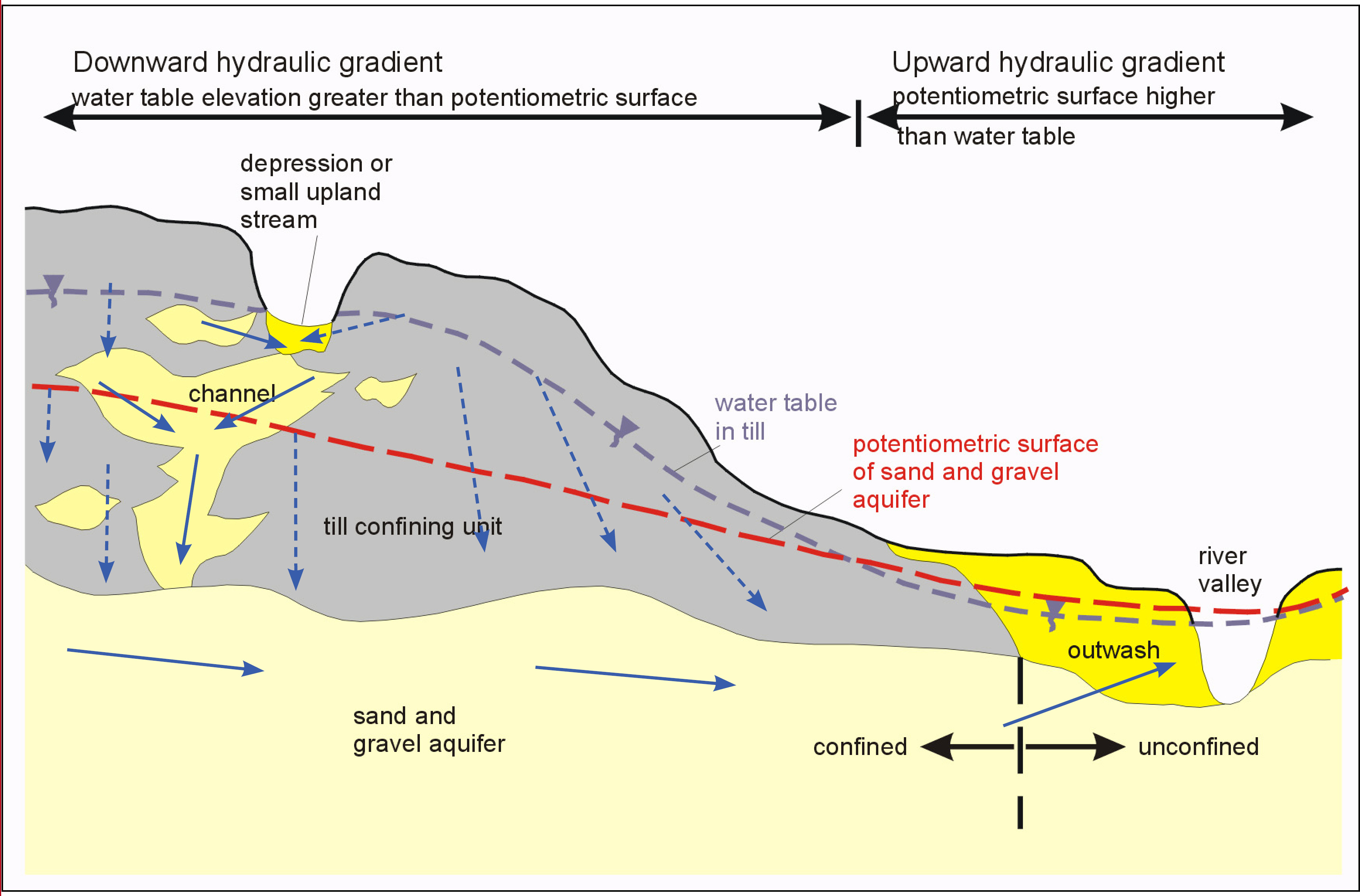
Figure 5.
Schematic diagram of a simple aquifer — confining unit situation along a major valley such as the White River, showing confined
and unconfined conditions and the relationship between the water table and potentiometric surface. Blue arrows indicate the
direction of groundwater flow in aquifer and confining unit. Groundwater flow is much slower, and predominantly vertical, in
the much less permeable till confining unit, as indicated schematically by the dashed arrows, whereas flow is faster and
predominantly horizontal in the permeable sand and gravel aquifer. (Adapted from Brown and Laudick, 2003.)
In general, horizontal flow is predominant in most large aquifers, whereas vertical flow is typically greater across thick confining units (fig. 5). Locations where different aquifers come into contact or are superposed, such as along major paleosurfaces where intervening confining units have been cut out, or where sand- and gravel-filled channels have cut through a confining unit, are often of great importance because they act as preferred conduits that enhance recharge (or discharge) into and out of deep aquifers, and may act as pathways for the migration of contaminants into aquifers that are otherwise confined and generally well protected from surface contamination.
The subject of groundwater recharge — how fast it occurs, how much occurs and at what times of year, where it occurs, and what specific mechanisms are involved — is complex, because the process takes place almost entirely out of sight and is very challenging to accurately measure at a single point in the landscape, much less over the area of an entire county. Nevertheless, the overall motion of groundwater through aquifers and confining units involves much recharge and discharge, and constitutes the groundwater flow system in any given area. Groundwater flow systems are typically represented by maps and cross sections that show the elevation of the water table and potentiometric surface(s) of major aquifers.
A generalized water-level map of the shallow aquifer system in Marion County (which may be viewed in the IMS portion of this Web site and is recommended while viewing the remainder of this web page) was made by using water-level data reported from wells developed in aquifers along and above the pre-Wisconsin surface. In upland areas, the shallow aquifer system is mostly overlain by sheets of till up to several tens of feet thick and is, thus, under confined conditions, whereas in and near the White River valley, this system is largely under unconfined (water table) or semiconfined conditions (see fig. 1). In the latter area, aquifers in the upper part of the system lie immediately below the modern land surface and are unconfined, whereas deeper parts of the system may be locally confined or semiconfined by extensive till sheets. Because of this range in conditions, the water-level contours are a composite feature representing the potentiometric surface in confined parts of the system and the water table for parts of the system that are largely unconfined. The difference between these areas is clearly indicated by the hydrogeologic settings on the map, but for simplicity, the entire contoured surface is referred to as the "potentiometric surface." Also, in some areas, there are few wells developed in the shallow aquifer system, consequently the elevation and configuration of the potentiometric surface were largely inferred from a few widely scattered water levels, surface topography, and the elevations of perennial streams in contact with the aquifer system. For all these reasons, these maps are intended to show only broad, regional trends of the potentiometric surface, and cannot be reliably used to infer local, small-scale flow directions within any particular aquifer.
Despite these limitations, the potentiometric contours reveal several important features. The most striking trend is the parallelism between the elevations of the water-level contours and modern surface topography. Elevated areas of the potentiometric surface coincide with topographically high areas, while major potentiometric valleys parallel the large topographic valleys associated with the major drainages. The contours broadly represent the hydraulic head at any given place in the aquifer system, thus the potentiometric map can be thought of as a two-dimensional representation of the distribution of hydraulic head within the aquifer system. As groundwater always flows from higher to lower head, the map clearly shows that groundwater originates at the potentiometric highs below uplands in the county, and flows towards the major drainages, such as the White River, Fall Creek, Eagle Creek, and other perennial streams. From this pattern, we can infer that these uplands are places where the shallow aquifer system receives considerable groundwater recharge, whereas much discharge from this system occurs in the major stream valleys. Indeed, the fact that the major streams continue to flow (albeit at a reduced rate) during periods of low or no precipitation indicates that their base flows are supported by abundant groundwater discharge. Most of that discharge comes from the shallow aquifer system, which is commonly in contact with surface streams and frequently underlies their beds. By the same token, periods of heavy precipitation and high stream flows cause surface water to leak back into the aquifer system along the surface streams, recharging the valley aquifers and contributing to the overall hydrologic balance that maintains stream flow throughout the year.
Another interesting feature of the potentiometric map is the relationship between the slope of the hydraulic gradient and surface topography. Potentiometric contours tend to be relatively widely spaced beneath both the large uplands and the broad stream valleys, reflecting a gentle horizontal hydraulic gradient. Lateral groundwater flow is likely to be comparatively slow beneath such places. To an extent, however, vertical groundwater flow is potentially of greater importance in such places, as demonstrated by large differences in water levels between wells developed in aquifers at varying depths. Beneath most uplands, for example, water levels become progressively lower in aquifers at greater depth, indicating downward flow (groundwater recharge), whereas the opposite is true beneath major stream valleys, in which water levels in deep aquifers are commonly greater than those in shallow aquifers, indicating upwelling of groundwater towards the surface. In contrast, the potentiometric contours are typically bunched closely together near the walls of the major valleys, indicating steep hydraulic gradients and strong inward flow of groundwater towards the modern streams. This process is visibly manifested at the modern land surface by lines of springs and seeps near the bases of large bluffs. Depending on the size of the aquifer involved and the strength of the hydraulic gradient, some of these springs and seepage areas may discharge groundwater at rates of hundreds to thousands of gallons per day within a relatively compact area, producing large seepage swamps and other kinds of ecologically valuable wetlands. Holliday Park, located along the White River bluff in north-central Marion County, preserves excellent examples of such features in a natural state.
Hydrogeologic Settings
The preceding discussion highlights the wide range of subsurface conditions that occur in Marion County. Differences in groundwater flow conditions coupled with much diversity in the geologic framework of aquifers and confining units means that the occurrence and behavior of groundwater varies greatly from place to place, often at a local scale. Although it is virtually impossible to capture all of the local variation at the level of a county-scale map, the concept of hydrogeologic settings offers one way of organizing some of this hydrologic and geologic variability into a geographic framework useful for understanding how major geologic terrains within the county function in terms of their surface hydrology and groundwater resources.
Hydrogeologic settings incorporate a combination of basic hydraulic data (for example, the potentiometric surface map
and recharge-discharge relations inferred from it) and geologic framework information (for example,