
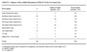
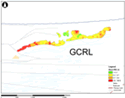
Grand Calumet RiverThe Grand Calumet River and Indiana Harbor and Canal (Calumet waterways) contain 5 to 10 million cubic yards (3.9 to 7.7 million cubic meters) of contaminated sediment up to 20 feet (6 m) deep (EPA, 2008). Contaminants include toxic compounds (e.g., PAHs, PCBs and heavy metals) as well as more conventional pollutants from industrial and urban runoff (e.g., phosphorus, nitrogen, iron, magnesium, solids, oil and grease). Historically, the Grand Calumet River supported highly diverse, unique ecological communities. The urban and industrial land uses and associated pollution have degraded the environment and impaired many desired uses of the area, including many identified beneficial uses. Many agencies and stakeholders are working in the Calumet waterways region to study, assess, plan, and implement restoration and remediation plans in an attempt to restore many of the beneficial uses of the area by remediating the many contamination issues. Below, a few links are provided to available resources and information available from those working to restore the Grand Calumet River and Indiana Harbor and Canal. Agencies and Stakeholders
U.S. Army Corps of Engineers - East Chicago Waterway Management District Online Resources
US FWS: Grand Calumet River Natural Resource Damage Assessment (NRDA) |
Info to know
Remediation efforts are underway in many areas of the LakeRim region in northwestern Indiana.
Remediation Highlights |
The legacy IGWS website is in the process of being decommissioned. Most services have been migrated to igws.indiana.edu. Only a few services will remain temporarily until the migration is complete..

Indiana Geological and Water Survey Home Page

Session Expiration
Your session for the Indiana Geological and Water Survey will expire in 30 minutes. Please refresh your broswer or click here to restart your session timer.