

Tectonic Features of Indiana
Indiana lies toward the middle of the North American continent, far from the coastal regions
and the mountains. We now know that continents move about the surface of the earth, bumping
into other continents and drifting away. This takes millions of years to happen, of course,
but the results can still be seen today in the rocks of the continents. The middle of most
continents has not been crunched or squished up the way the edges have been. That is because
the middle of the continents are made of very strong old rock. This part of the continent is
called the stable
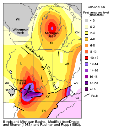
While much of the stable craton is exposed at the surface north of Indiana as the Canadian Shield, the middle part of the craton, located in the United States, is covered with sedimentary rocks of the Interior Platform (see figure to the right). This sequence of rocks (see Rocks) varies from approximately 3,500 to in excess of 20,000 feet in thickness. The cratonic rocks are metamorphic and igneous while the overlying sedimentary rocks are composed mostly of limestones, sandstones and shales. These sedimentary rocks were deposited from 650 to 290 million years ago. The metamorphic and igneous rocks of the "basement complex" were created 1.5 to 1.0 billion years ago in a tectonically active setting. We don't know much about this setting but by observing the textures and compositions of these rocks we know that it was setting of great pressure and temperature. The younger sedimentary rocks that were deposited on top of this basement complex were formed in a setting of quiet marine and river waters. Much of this time the craton was covered by a large shallow sea, a so-called "epicratonic sea" (meaning literally "on" the craton). Sometimes land masses or mountain chains rose up on the distant edges of the craton and then eroded down, shedding their sand across Indiana. These sediments whether deposited in rivers or seas eventually compacted into the sedimentary rocks that cover the state today.
We know that the tectonic setting of Indiana has remained relatively stable for the last 650
million years because the rocks are still relatively flat and undisturbed. The rocks do however
change in thickness across the state. This is because they were deposited in low spots called
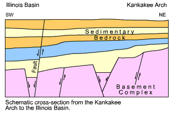
The youngest bedrock formations that occur in Indiana are 290 million years old. We have no "rock record" to tell us about events that took place in our state since that time. We can however look at the structures or tectonic signatures in the rocks present and deduce the age and amount of tectonic "deformation" that has gently shaped our rocks. If we look at a slice through the bedrock including the sedimentary rocks and the basement complex we can put together a tectonic history of the state (see figure below and to the left).
Beginning at the bottom of the cross section, we can see that large cracks formed in the basement
complex about 650 million years ago. These cracks are called
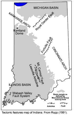
The map to the right is a tectonic map of Indiana. This map shows where the edge of the Illinois and Michigan Basins lie, as well as the location of the known fault systems that are found in the state. The "tick marks" on the faults show the side of the fault that has gone down relative to the other side. Some faults probably experienced multiple episodes of faulting. There are many faults that lie deep within the basement complex that are covered by sedimentary bedrock.
Some of the faults that we see in the rocks today may have formed millions of years ago and have long since been "extinct." Other faults that we see in the bedrock (and even some that we don't see because they are covered by soils, glacial deposits or vegetation) may possibly be active today. Seismicity relating to the Wabash Valley Seismic Zone or possibly the New Madrid Seismic Zone, located southwest of Indiana, could potentially affect southern Indiana. Some parts of the world are tectonically very active and we can see and measure this activity. Mountain ranges are forming where two continents are bumping into each other. An example of this is the Himalaya Mountains in Asia. These mountains are rising at almost a half-inch per year. There are also lots of big earthquakes associated with tectonic processes and these also can be measured. Because Indiana is located in the stable interior of the craton, we do not have much movement of the bedrock nor do we have many big or frequent earthquakes. Indiana is a good example of places on the earth that are tectonically quiet.