
Age:Silurian Type designation:Type locality: The Manitoulin Dolomite Member of the Cataract Formation was named by Williams (1913) because of its importance on Manitoulin Island in the northern part of Lake Huron, Ontario (Rexroad, 1986, p. 86). History of usage:On Manitoulin Island, the Manitoulin Dolomite Member underlies the Cabot Head Shale, although in places the two are also in a facies relationship (Rexroad, 1986). Both of these units are considered as formations in that area (Liberty, 1968), but in Indiana both are thin and gradational and are given member rank in the Cataract Formation in the area in the northern part of the state where they can be separated (Rexroad, 1980, 1986). Description:The dolostone of the Manitoulin is variable. It is rather pure and slightly vuggy to very argillaceous and contains many thin shale partings; it is also fine grained to very coarse grained and fossiliferous and light tan to brown, gray brown, and gray (Rexroad, 1986). The Manitoulin is less than 20 ft (6 m) thick in Indiana except possibly in northern Steuben County, where it may be somewhat thicker (Rexroad, 1980, 1986).
Boundaries:The Manitoulin rests unconformably on rocks of the Maquoketa Group (Upper Ordovician) and is gradationally overlain by the Cabot Head (Rexroad, 1986). Correlations:The Manitoulin of Indiana is continuous with the Manitoulin Dolomite (Cataract Group) of Michigan (Rexroad, 1986). To the south it is in a facies relationship with the Brassfield Limestone and to the west with the Sexton Creek Limestone (Rexroad, 1986). It contains conodonts of the Distomodus kentuckyensis Assemblage Zone and is approximately middle Llandoverian in age (Alexandrian in the North American standard) (Rexroad, 1980, 1986). |
|
Regional Indiana usage:
Kankakee Arch (COSUNA 14)
Misc/Abandoned Names:None Geologic Map Unit Designation:Scm Note: Hansen (1991, p. 52) in Suggestions to authors of the reports of the United States Geological Survey noted that letter symbols for map units are considered to be unique to each geologic map and that adjacent maps do not necessarily need to use the same symbols for the same map unit. Therefore, map unit abbreviations in the Indiana Geologic Names Information System should be regarded simply as recommendations. |
COSUNA areas and regional terminologyNames for geologic units vary across Indiana. The Midwestern Basin and Arches Region COSUNA chart (Shaver, 1984) was developed to strategically document such variations in terminology. The geologic map (below left) is derived from this chart and provides an index to the five defined COSUNA regions in Indiana. The regions are generally based on regional bedrock outcrop patterns and major structural features in Indiana. (Click the maps below to view more detailed maps of COSUNA regions and major structural features in Indiana.) 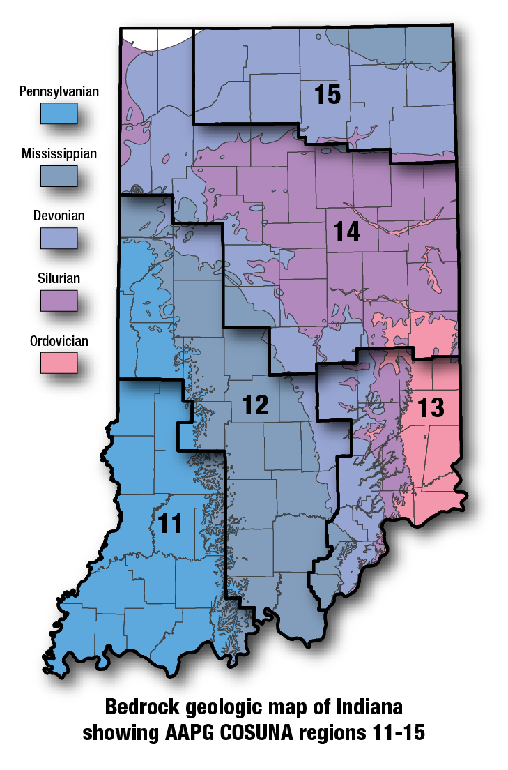
COSUNA areas and numbers that approximate regional bedrock outcrop patterns and major structural features in Indiana. 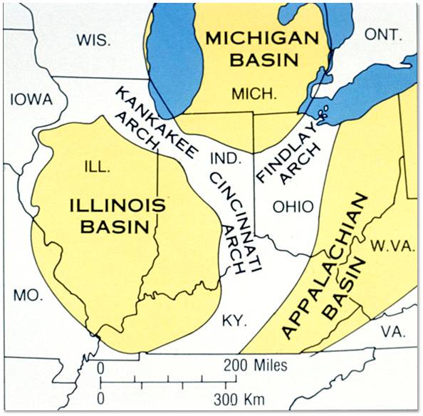
Major tectonic features that affect bedrock geology in Indiana. |
See also:
Brassfield Limestone
References:Hansen, W. R., 1991, Suggestions to authors of the reports of the United States Geological Survey (7th ed.): Washington, D.C., U.S. Geological Survey, 289 p. Liberty, B. A., 1968, Ordovician and Silurian stratigraphy of Manitoulin Island, Ontario: Michigan Basin Geological Society Annual Field Trip, 1968, p. 25–37. Shaver, R. H., coordinator, 1984, Midwestern basin and arches region–correlation of stratigraphic units in North America (COSUNA): American Association of Petroleum Geologists Correlation Chart Series. Williams, M. Y., 1913, Revision of the Silurian of southwestern Ontario: Ottawa Naturalist, v. 27, p. 37–38. |
|
For additional information, contact:
Nancy Hasenmueller (hasenmue@indiana.edu)Date last revised: July 28, 2017
