

Ice Ages in the Geological Record
The Ice Age refers to the period of geologic time encompassing the past 2 to 3 million years or so when the earth's higher and mid-latitudes experienced widespread glaciation by huge, continental-scale ice sheets. Geologists also refer to this time as the Pleistocene, a formal period of geologic time that began 2 million years ago and technically ended 10,000 years ago. The Ice Age is the most recent of several periods of widespread glaciation that have affected the earth. The geologic record indicates that major episodes of glaciation occurred at least as far back as 2.4 billion years ago, when life was far less evolved than today, as well as during the Carboniferous (~300 million years ago) and Ordovician (~450-500 million years ago). Other glacial episodes of less certain magnitude are also known from the rock record. So it appears that periods of much colder climate, marked by major incursions of ice sheets into lower latitudes, are a regularly recurring feature of our world.
The Ice Age Climate
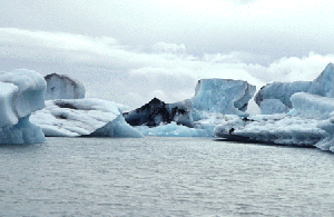
It is clear that the global climate during the Ice Age was substantially colder than the comparatively mild one we inhabit today. But scientists debate both the absolute magnitude of cooling that occurred during the Ice Age as well as how patterns of weather were affected. The best evidence seems to suggest that, globally, the average air temperature was cooler by some 6 to 12° Celsius, and that daily temperature at latitudes such as Indiana fluctuated seasonally almost as much as they do today. However, there is little doubt that global weather patterns were substantially different, causing large regions in northern and eastern Canada to receive massive amounts of snowfall and to remain below freezing most of the year. Year after year, the layers of unmelted snow continued to compact into dense ice under their own weight, forming ice caps not unlike that in Antarctica today. Ultimately, these great masses of ice began to flow outward under the stress of their own weight, and the continental ice sheets were born.
A Continental Ice Sheet
As the ice sheets began to move southward out of the Hudson Bay and Labrador regions, they encountered a rolling landscape mantled with relatively thick soil and locally dissected by large river and stream valleys—not unlike that found today in parts of southern Indiana and neighboring states to the south. Ice behaves much like water, following the course of least resistance. That is why scientists believe that ice flow was initially directed along the courses of large bedrock valley systems that had developed over tens of millions of years of stream erosion during the generally mild and wet period known as the Tertiary. Some of the largest of these valleys were thought to lie along what is now the U.S.-Canada border, and were deeply incised into relatively weak rock types like shale. As the first glaciers moved over these valleys, they began to carve the soft rock into great basins, creating the forerunners of what we know today as the Great Lakes. The orientations of these basins greatly influenced the directions and even the scale of all subsequent ice advances into Indiana.
The very first ice sheet that entered Indiana appears to have arrived sometime before 700,000 years ago and came straight from the north, out of what is now Michigan. We know this because the sediments associated with this earliest glacier are choked with fragments of coal, sandstone, and distinctive reddish claystone—all rocks that come only from the center of Michigan, and these sediments are magnetically reversed, meaning that the North and South Poles were flipped! Although the Earth's polarity has reversed countless times in the geologic record, the most recent episode occurred some 700,000 years ago, during the Ice Age.
This ice sheet moved very slowly from north to south, encountering many bedrock hills and valleys that impeded its progress. As it crossed the landscape this first glacier completely changed the surface drainage that had taken millions of years to develop, damming up river valleys into lakes, diverting stream channels to the south, and in some cases completely filling up large valleys with sediment, leaving little record of their existence. The giant Teays bedrock valley system was one such victim. This valley system was the premier drainage way in eastern North America prior to glaciation, extending from its headwaters in the western mountains of North Carolina and Virginia to the Mississippi River in western Illinois. The gorge-like valley of this river was as much as 200 to 400 feet deep and crossed north-central Indiana between about Berne (Adams County) and Lafayette (Tippecanoe County). Today, there is virtually no trace at the modern land surface of the once giant river—only a deeply buried valley on the bedrock surface defined by various wells and test borings. The glacier also mowed down forests of spruce, birch, and other northern trees that had taken up residence in Indiana in response to the colder climate. This first glacier ultimately stopped somewhere about mid-state and slowly retreated northward, back into Canada, as the climate began to warm slightly, and temporarily.
Fashions and Clothing-Industry Trends During the Ice Age
Environmental conditions near this ice sheet would have been harsh indeed! Possibly as much as a half-mile to a mile thick, the imposing ice front would have been the scene of frigid cascades of meltwater and icy lakes amidst a landscape of thick, cold mud put in motion by constant freeze-thaw activity and water. The sense of desolation would have been compounded by the constant pounding of katabatic winds—cold blasts of air that roar off of the glacier as air masses passing over the ice surface are abruptly chilled and sink rapidly. In fact, an ice sheet of this scale would have probably made its own local weather. Sudden cooling of warm, moist masses of Gulf air encountering the cold ice sheet would have created torrential summer rains and near-constant "glacier-effect" snow in winter. During midsummer, at its southern extent in central Indiana, it is likely that one could have stood next to the glacier wearing shorts and a tee-shirt in weather similar to what we would experience today on a warm day in May! But the incessant cold wind pouring off the ice would be a constant reminder of the bitter winter to come.
A Landscape in Motion
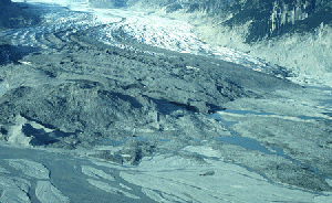
Glaciers can be thought of as rivers of ice, slowly flowing outward from their source to their terminus. Rates of ice flow range widely, but it is thought that the glaciers that affected Indiana probably moved relatively rapidly because they had abundant water at their bases to help "lubricate" their sliding motion over their beds. This sliding motion allows a vast amount of older rock and sediment to be eroded from the bed of the glacier, where it becomes frozen into the lower part of the ice. Thus, glaciers could be viewed in one sense as "conveyor belts", constantly transporting sediment from back up under the ice to the glacier margin. The edge of a glacier is where the ice is always melting. When melting rates are slow (for example, during winter or other especially cold times) and accumulation of new ice is rapid, the ice margin moves outward, or advances, whereas when melting rates are high, the opposite is true. In any event, the constant melting that goes on at the margin of a glacier releases vast amounts of entrained sediment, some of which may have traveled as frozen debris in the glacier for hundreds or even thousands of miles from its source. At the scale of the continental ice sheets, the quantity of sediment transported must have been astonishing. In Indiana alone, countless tens of feet of soil and bedrock were stripped off the landscape and redeposited down-glacier, along with even larger quantities derived from areas farther north. Hence, it is not surprising that the deposits of Ice Age glaciers are the dominant material in the Indiana landscape today, ranging up to several hundred feet thick in some places in the north.
But a landscape need not be directly affected by ice to be dramatically changed. As noted above, conditions just outside of a continental ice sheet are severe. Precipitation of potentially monsoonal proportions, coupled with a far greater frequency and intensity of freezing and thawing can set entire landscapes in motion. Recently thawed, super-saturated sediments on even a gentle slope will move easily under their own weight, creating widespread mud flows and extreme instability of the landscape. This process, called "solifluction", was probably very widespread within a zone of tens to perhaps a hundred miles wide fringing every ice sheet that invaded Indiana. The most extreme example of this landscape is permafrost, where a thick layer of permanently frozen ground exists at a shallow depth beneath a thin upper layer that experiences annual freeze and thaw action. The boundary between the frozen substrate and the soupy surface material is exceptionally unstable and results in constant rearranging of the landscape. There is good evidence that localized permafrost existed in a few places in northern Indiana during the waning stages of the Wisconsin ice sheet, and it seems quite possible that permafrost may have been more widespread during parts of the Illinoian glaciation, when the coldest global temperatures of the Ice Age were recorded in sea floor sediments and the ice sheets in Indiana extended to the Ohio River.
The Ice Age Record in Indiana
The record of glacial events in Indiana is very complex and incomplete. It is problematic to specify with any certainty how many times ice sheets have invaded the state following the very first event noted above. The tendency of successive ice sheets to erode earlier glacial deposits produces many discontinuities in the geologic record. Consequently, the older events tend to be very poorly represented in our record, which is dominated by deposits from the most recent ice advances. However, the climatic record observed from cores in the Greenland Ice Sheet and from geochemical evidence in the ocean floor suggests that there may have been as many as 12-18 different climatic periods in the past 1-2 million years that were cold enough to cause continental ice sheets to form. The geology of Ice Age deposits in Indiana is too poorly worked out to determine whether there is a direct correspondence to the global climatic record, but evidence from a few isolated areas of thick deposits indicates that at least 11 different and distinct glacial events affected the state. In general, geologists divide these events and the glacial deposits of the Ice Age into three great stages, each of which experienced several ice advances:
- The Wisconsin Stage, which began about 50,000 years ago. Nearly all of the modern landscape of the northern two-thirds of the state, and a large part of the deposits beneath, are the product of this stage.
- The Illinoian Stage, which took place from about 300,000 to 140,000 years ago. These deposits are exposed at the modern land surface in southeast and southwest Indiana, beyond the limit of the Wisconsin ice sheets. They also occur in the subsurface throughout the rest of the state, beneath the overlying Wisconsin deposits.
- The pre-Illinoian Stage, which is much less clearly understood and includes everything else before the Illinoian. Several events from this stage are known to have affected Indiana, and the deposits that record them occur in widely scattered localities in the subsurface.
Vestiges of Ice Age Summer
It is evident from the above chronology that there were long parts of the Ice Age when no ice sheets were present. Some of these periods, termed "interglacials", lasted many tens of thousands of years—far longer than our comparatively brief modern ice-free time. Shorter periods of ice-free conditions are termed "interstadials"— generally lasting at most a few thousand years. The interglacial periods were typified by climates not unlike our own, with warm, temperate conditions. Parts of some interglacials may have been substantially warmer, others somewhat cooler, but in all of them, familiar processes of landscape formation were occurring. Rivers cut great valleys, sediments weathered to form thick soils, and forests and prairies dominated by temperate vegetation pushed the tundra and spruce forests northward. Evidence for these ancient landscapes can still be observed at a few places in southern Indiana, where the older glacial deposits are at the modern land surface. There, soils are dramatically thicker than those developed on the much younger deposits north of the Wisconsin glacial limit, indicating that they formed over a much longer period of time. Vestiges of these ancient interglacial landscapes are also present in the subsurface north of the Wisconsin limit, where they are manifested by brightly colored buried soils immediately beneath the next succeeding group of deposits. Sometimes, if one is lucky, exposures of these buried surfaces turn up beds of moss and trees—relics of the vegetation that occupied Indiana in interglacial times. In a few places, as many as five such buried landscapes have been identified in a single, deep borehole!
The Ice Age Legacy
Although the geologic record in Indiana dates as far back as a billion years and encompasses a myriad of changes in the geologic environment, no other event since the extinction of the dinosaurs 65 million years ago can compare to the Ice Age in terms of the profound affect it had on our landscape and the natural environment in which we live today. In fact, virtually all of societal affairs are in one way or another affected by some facet of the Ice Age. For example, ground water supplies some 90% of the Indiana population with all water used for domestic consumption and associated economic activity, and nearly all of the major aquifers that yield this ground water are a direct consequence of glaciation. The major rivers in whose valleys we established our major communities and that we utilize as our major recreation resources are all former glacial rivers that drained the melting ice sheets. Glacial deposits are an abundant and inexpensive source of mineral aggregates and they provide a secure foundation for our wide-ranging infrastructure. Likewise, the occurrence of the world's most productive agricultural lands in the Midwest is no coincidence. Glacial deposits consist of finely ground fragments of a myriad of rock types, and the rich soils that have developed on them contain a virtual A to Z of major and minor plant nutrients. Few other geologic settings can boast of all of these amenities.
Global Climate Change and the Ice Age
Based on the geologic and climatic records, geologists believe the present climate may only be a short interlude between glacial episodes, but of sufficient duration to allow many species of plants and animals, including homo sapiens, to spread to the corners of the globe, into areas that were once beneath a mile or more of solid ice as recently as 10,000 years ago. Are the foundations of our civilization perhaps based only on what will turn out to be a relatively short interglacial period? Using evidence from fields as diverse as climatology, astronomy, and the geologic record, some scientists have suggested that we may be due for several more major continental glaciations over the next few tens of thousands of years. On the other hand, glaciers today are melting and retreating more rapidly than any other time in recorded human history. From Glacier Park in Montana to the Antarctic Ice Cap, areas covered by active glaciers as recently as 100 years ago are now ice free, and there is speculation (thus far unconfirmed) of impending collapse of large parts of the Antarctic ice shelf. A consensus of many of the world's leading scientists is that these events are harbingers of global climate change, specifically a warming of the atmosphere and oceans resulting from human intervention. This so-called "greenhouse effect" is believed to be the principal consequence of the 50% increase in atmospheric carbon dioxide (and to some extent, other gases) in the 200 years since the industrial revolution began. More than 160,000 years of data extracted from the Greenland Ice Sheet leaves little question that global temperature shows a direct correlation with carbon dioxide content over long periods of geologic time (see graph).
Because of the vagaries of weather patterns and the fact that global temperature is only an average of extremes, however, the effect of these changes at any given place or region is highly uncertain. One school of thought is that present climate zones will shift toward higher latitudes, leading to further rapid melting of the ice caps in the polar regions as well as most of the world's remaining temperate glaciers. But another possibility is that substantially warmer ocean surface temperatures will lead to much higher rates of evaporation, thus resulting in far greater cloud cover than we see today. Clouds reflect back much of the incoming solar radiation, and some models suggest that an increase in cloud cover of as little as 20-30% could actually lower global temperatures significantly. Because our record of detailed observation is so short, such feedback mechanisms are very poorly understood, leading to a very limited ability to predict actual changes in global climate, including the possibility of a resurgence of glacial activity in temperate latitudes. Either way, it seems all but certain that the relatively mild, temperate climate we now enjoy is but a fleeting moment in the vast span of geologic time we refer to as the Ice Age.