

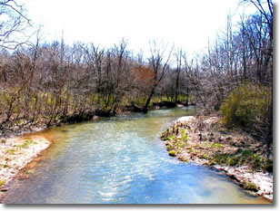
Stream in Johnson County, Indiana, with riparian vegetation.
Most bodies of water, both running and standing, have a floodplain or transitional riparian area. These areas are called riparian buffers, and they are beneficial because they slow water runoff, trap sediment, and enhance infiltration. Often, the natural transition zone is altered through various land uses, and the protective nature of the riparian zone becomes ineffective or even detrimental to the health of the water body. Such problems have been encountered in the 130-square-mile Young's Creek Watershed in Johnson County, Indiana. The specific waterquality problems for the watershed involve an influx of chemicals and excessive sediment from both agricultural and urban sources. These problems can be minimized by managing or restoring vegetated riparian buffer zones.
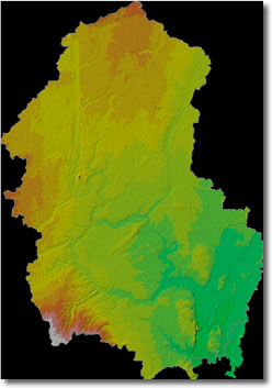
Hillshaded topography of Young's Creek Watershed in Johnson County, Indiana.
The problems in the Young's Creek Watershed are not unique. Because of a long agricultural tradition and ever-expanding urban and suburban development, watersheds along the periphery of Indianapolis are especially threatened as development increases runoff and imposes stress on existing riparian corridors. The different land uses create complex hydrologic interactions because of the effect that increasing impervious areas in headwaters has on watersheds. Increased runoff is a result of urban land use, which increases the dispersal of contaminants downstream. The urban runoff increases channel erosion downstream and then deposits the eroded sediment into the lower watershed where it destroys habitat, decreases flow capacity, and eventually promotes flooding.
To support riparian management of the watershed, we have developed a method of evaluating riparian buffer zones using geographic information systems (GIS), remote sensing, and hydrologic modeling. This methodology allows efficient identification of degraded riparian areas in the watershed and, in addition, provides a basis for assessment and prioritization of areas to target for restoration. Our multi-phased approach involves using remote and on-site methods to describe the stream reaches within the watershed on the basis of channel geometry, land use, soil types, and vegetation.
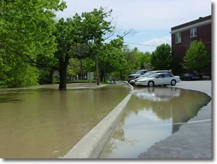
Flooded parking lot in Franklin, Indiana.
Our assessment of the conditions in the watershed uses both remote and field methods. The first phase of the evaluation is to assess the current status of buffers (width and type) in the watershed. Existing buffers are digitally mapped on an aerial photograph base. Multiple field surveys are used to ground truth our remote sensing methods. Using available data, we catalog the stream reaches within the watershed on the basis of morphology, land use, and vegetation. For each reach of stream in the drainage network, we conduct an assessment of the dimensions of the probable natural riparian buffer based on fluvial geomorphological considerations. We then identify locations where the current riparian buffer is narrower than would naturally occur without modification. On the basis of land uses that contribute to the degradation of streams (for example, land uses associated with impervious surfaces), we identify stream reaches that currently have insufficient riparian buffer zones by ranking the stream reaches from least impacted to most impacted. Such areas are identified by excessive bank erosion or evidence of water-quality or aquatic-habitat degradation due to migration of contaminants into the waterway. We then determine where the vegetated riparian buffer is absent or of insufficient width to adequately protect the reach from degradation. A reach that is impacted and has an insufficient buffer zone is an example of an area having a high priority for restoration. The amount of additional buffering (in width, density, or type of buffer) required is often dependent on the land use; however, other factors considered include the size and slope of the area contributing to the stream reach, as well as the infiltration characteristics of the soil types. For example, contributing areas consisting of farmland require larger buffer widths if the area is overlain with soils of low permeability.
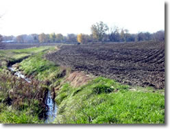
Stream with no riparian buffer vegetation adjacent to farm land, Johnson County, Indiana.
The second phase of our evaluation involves using a numerical model to simulate hydraulic routing through a branching channel network subject to lateral inflows from contributing interfluves. Using the high-resolution topographic data available for the watershed, we extract channel and reach characteristics for input to the hydrologic model using GIS methods. In addition, we use ancillary information such as the U.S. Geological Survey National Land Cover Database (NLCD) and a digital version of the Natural Resources Conservation Service (NRCS) county soil survey (SSURGO) to provide detailed attributes to describe subwatersheds. The soil maps provide information such as geologic parent material and expected infiltration characteristics, whereas the NLCD provides information about the types and distribution of materials (natural and anthropogenic) at the ground surface. All ground-cover materials are assigned hydrologic characteristics, which are used in the hydrologic model.
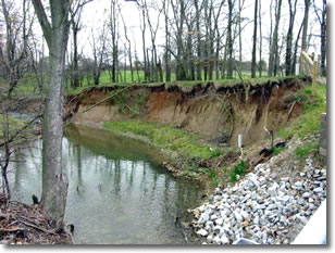
Bank erosion next to stream, Johnson County, Indiana.
Multiple runs of this model can simulate the effect of adding or removing buffers throughout the watershed. The various modeled scenarios were designed to evaluate areas having the potential for flooding or increased erosion. More importantly, however, is the ability to use the GIS data in conjunction with results of the hydrologic modeling not only to identify impaired reaches, but also to determine the upstream causes and locations of excessive runoff. In the Young’s Creek watershed, we found that headwater tributaries with missing or insufficient riparian buffers are the primary source areas of negative impacts on the downstream channels.
The Johnson County Soil and Water Conservation District (SWCD) has developed a Watershed Management Plan. This plan outlines a baseline assessment of water-quality issues within the watershed, identifies solutions, and provides recommendations. They are currently implementing some of the recommended solutions for water-quality improvement.
Links to some additional resources
Riparian structure, function, and management at many scales are topics of interest across the nation, and there is a wealth of additional information on riparian buffers.
- USDA Natural Resource Conservation Service - National Conservation Buffer Initiative
- Federal Interagency Stream Corridor Restoration Working Group - Stream Corridor Restoration
- Core 4 Conservation - Conservation Buffers
- The Nature Conservancy - The Invasive Species Initiative
- Connecticut River Joint Commissions - Riparian Buffers for the Connecticut River Valley
- University of Maryland - Riparian Buffer Systems
- Chesapeake Bay Program - Riparian Forest Buffers
This work was funded by a U.S. Environmental Protection Agency Clean Water Act Section 319 grant, which was administered by the Indiana Department of Environmental Management's (IDEM) Watershed Management Section. The IDEM project manager for this project was Kathleen Hagan.
For more information on this project, contact Sally Letsinger at sletsing@indiana.edu.