

New Understanding of Lagro Formation Aids Evaluation of Aquifer Sensitivity
Recent drill-
 Figure 1. Schematic cross section of Lagro Formation geology
Lagro 1 subglacial
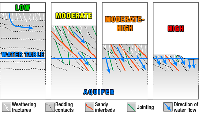 Figure 2. Schematic of aquifer sensitivity
The range of Lagro Formation characteristics and their integrated influence on
Low sensitivity (green): moderate to high thickness, horizontal bedding, slow
Moderate sensitivity (yellow): moderate thickness, relatively low density of gravelly sand interbeds, jointing, and weathering fractures, some preferential flow to water table along bedding planes and fractures. Lagro ice-marginal till in Allen County is typified by these characteristics.
Another suite of characteristics can lead to moderate sensitivity to contamination in Allen County. A thin deposit having a relatively high density of gravelly sand interbeds, jointing, and weathering fractures, and some preferential flow to the water table along bedding planes and fractures is often found in Lagro subglacial till over ice-marginal till.
 Figure 3. Aquifer sensitivity to contamination (provisional 2012), Allen County, Indiana
Moderate-high sensitivity (orange): moderate thickness, moderate-to-high relative density of gravelly sand interbeds, little jointing, and weathering fractures, recharge to water table through fractures and bedding planes. Lagro ice-marginal till having many fractures and bedding planes hosts this sensitivity classification.
High sensitivity (red): thin, relatively high density of gravelly sand interbeds, jointing, and weathering fractures, rapid recharge, or alluvial sediments with high permeability. Lagro ice-marginal till or alluvial sediments having little or no overlying low-permeability sediments are highly sensitive deposits in Allen County.
Lagro Formation geology strongly influences its
References:
Fleming, A. H., 1994, The hydrogeology of Allen County, Indiana geologic and ground-water atlas: Indiana Geological Survey Special Report 57, 111 p.
Wayne, W. J., 1963, Pleistocene formations in Indiana: Indiana Geological Survey Bulletin 25, 85 p.