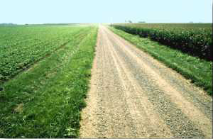
Photo of soybean and corn fields on the flat Tipton Till Plain of central Indiana.
Gazing out over the flat landscape of Howard County around Kokomo, you might think that the scenery is, frankly, boring. Indiana's central plain clearly does not rival the diverse geologic landscapes of the world's most scenic places. However, the processes that formed this panorama are complex and fascinating. And with a bit of knowledge about how glaciers affected this area, you will see that the modern surface, apparently so plain, is in reality very intricate.
Left much as when the last glacier melted 16,000 years ago, the landscape today reflects a series of climate-related surges of the massive Laurentide ice sheet that still covered all Canada and parts of the Midwest. About 17,000 years ago, a tongue of the ice sheet surged southwestward to Indianapolis, then melted in place over many centuries. The icy surface was covered with deep crevasses and frigid ice-walled lakes in what is now Russiaville. Eventually the ice advanced again straight westward, carving the remarkable Young America flute field (mostly north of State Road 18), and then again southwestward to form the Windfall crevasse fan. Finally, the glacier made one last massive advance to the Union City Moraine.

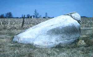
This former Canadian resident arrived in one of the glacial advances into central Indiana. These transported rocks are known as "glacial erratics," and can be seen around Kokomo gracing front yards and flower gardens, as well as in farmers' fields.
Beneath the scoured glacial debris, called "drift," is the land surface as it was before the presence of the glacier, about a million years ago. The thick rich soils that grow Indiana's corn and soybeans owe their existence to this glacial debris. This soil is one of the most beneficial legacies of the ice age; Indiana's agricultural wealth can be attributed, in part, to sediments carried by the glaciers from as far away as Canada. Buried soils represent warm periods between glacial advances and are key markers for geologists sorting out the periods of time that the ice surged and retreated.
The understanding of glaciers and the geology of the region is tied to future planning for land use, the extraction of minerals, and the protection of the ground water we need for drinking and irrigation of farmland. These issues are directly related to the nature of glacial deposits, since aquifers the water-bearing formations under the surface are also part of the legacy of the glaciers.


