
Northern Indiana was repeatedly covered by continental ice sheets during the past one million years or so, which produced a thick
section of
The flow of continental ice sheets developed along distinct axes paralleling the Great Lakes basins, producing well-defined glacial
lobes, each having a characteristic set of
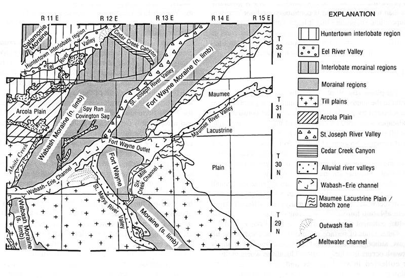 Figure 1.
Map of Allen County showing selected glacial landforms and related features (from Fleming, 1994a).
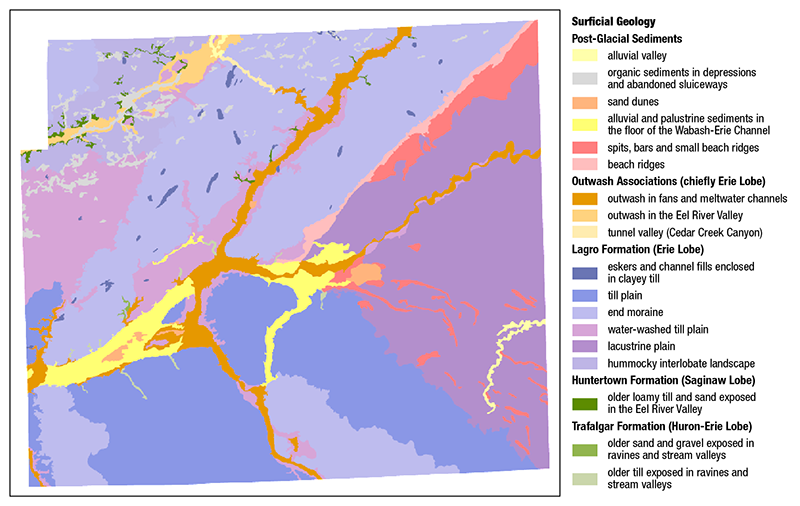 Figure 2.
Surficial geologic map of Allen County as presented in the interactive map portion of this website. The map is presented in more detail as Plate 5 of Indiana Geological Survey Special Report 57 (Fleming, 1994a).
Three major late Wisconsin glacial episodes are recognized in Allen County, beginning with the advance of the
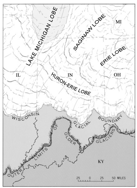 Figure 3.
Generalized map of the glacial lobes present in Indiana during the late Wisconsin age. This map is modified from Bleuer (1974b).
This event produced the most widespread sequence of glacial deposits, known as the
The sample shown in figure 4 is from a gravel unit between the Lagro and Trafalgar Formations, collected via downhole sampling of a well drilled in Jefferson Township, eastern Allen County.
A second sequence, known as the
The late Wisconsin culminated in the readvance of the
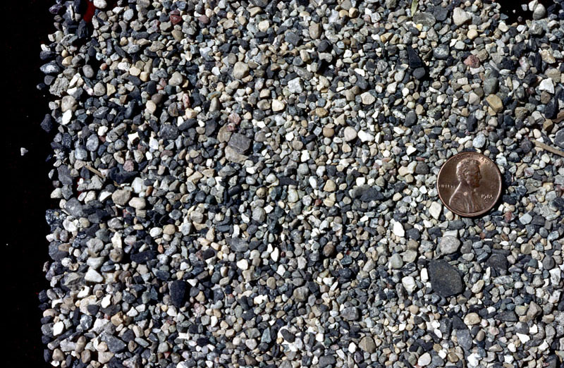 Figure 4.
A sample of an eastern source (Erie Lobe) gravel.
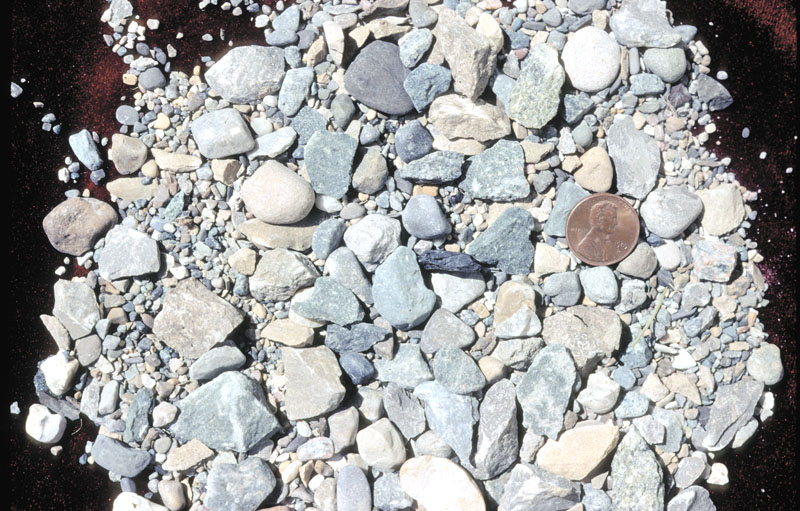 Figure 5.
A sample of northern source gravel presumably deposited by the Saginaw Lobe.
Trafalgar Formation
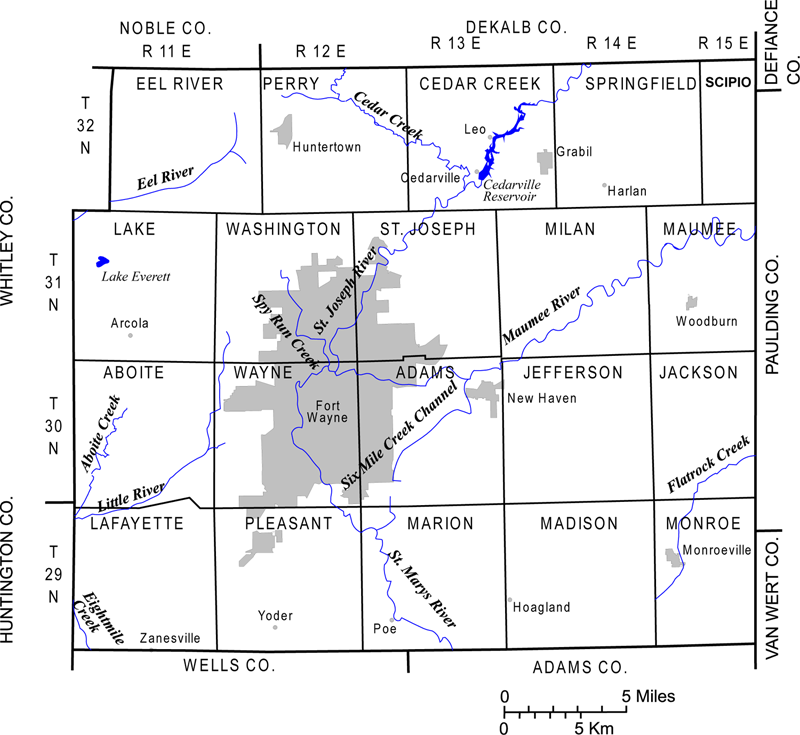 Figure 6.
Map of Allen County showing the political subdivisions and the geographic localities referred to in the text.
The Trafalgar Formation (Wayne, 1963; Bleuer, 1974a; Bleuer and Moore, 1972; 1978; Fleming, 1994a) is at the land surface in much of central Indiana (Gray, 1989); however, it is buried by younger glacial deposits and is only exposed in stream valleys and ravines in much of Allen County. The unit forms a prominent horizon throughout the county at depths ranging from as little as a few feet below downtown Fort Wayne and the Wabash-Erie Channel to more than 150 ft in the northern sections of the county (fig. 6). The Trafalgar Formation is a sequence of loam-textured till, sand and gravel, silt, and mud flows; however, it is composed chiefly of very hard, stony, loam-textured till (fig. 7).
This basal outwash is an important aquifer throughout the county. Other types of sand and gravel bodies are also abundant in the Trafalgar Formation. Most of these consist of small, localized lenses enclosed in the hard till, but much larger bodies do occur, especially in southwest Allen County, where a series of sizable, wedge-shaped bodies of channel-like form are prominent. Some of these can be traced for miles in the subsurface, and appear to mark the locations of earlier meltwater outlets active when the Trafalgar Formation was being deposited. Many of the channel deposits in Aboite and western Wayne Townships (fig. 8) are 50 to 100 ft thick and extend completely through the formation, where they allow groundwater recharge through the otherwise poorly permeable till.
Surface exposures of the Trafalgar Formation (shown as map units T and Tc on the surficial geology map) are limited to a few ravines and other low-lying areas near the Wabash-Erie Channel, where the Maumee Torrent or modern streams stripped off overlying sediments such as the Lagro Formation.
The till is severely
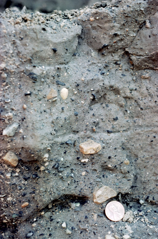 Figure 7.
This photograph shows a typical hard, stony, basal meltout till of the Trafalgar Formation. This unit has conspicuous sub-horizontal fabric produced by aligned platy clasts of dark Ordovician limestone, black Antrim (Ohio) Shale, and tan Paleozoic limestone and dolomite, and by a vague layering of till units separated by thin horizontal partings filled with sand. Stone Street Quarry, Marion Township, southern Allen County.
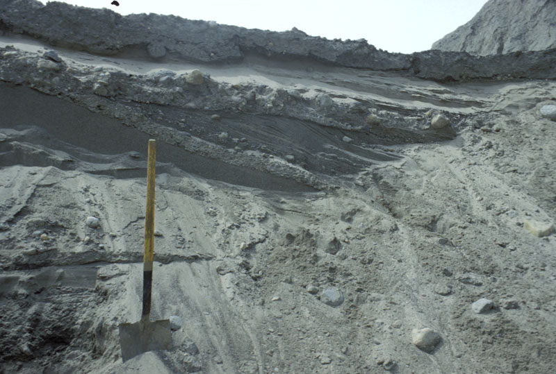 Figure 8.
This picture is of loamy debris flows embedded in the top of the basal outwash unit (gravelly sand) of the Trafalgar Formation. The debris flows are remobilized till thought to have flowed off of the advancing ice front, just before the glacier overrode the outwash. Stone Street Quarry, Marion Township, southern Allen County.
Huntertown Formation
The Huntertown Formation (map unit H) was named by Fleming (1994a) for a distinctive group of predominantly sandy sediments in the shallow subsurface of northern Allen County.
The sequence contains abundant and commonly large, bodies of sand and some gravel (fig. 9) that account for as much as 50 to 75 percent of the apparent thickness of the unit in most
locations. The granular units are associated with
In Eel River and Perry Townships (Fig. 8), it is not uncommon for the till to be thin or absent, resulting in a thick composite section of sandy sediments. All of these lithologies
contain features strongly suggestive of a northern (Saginaw Lobe) provenance or source: conspicuous clasts of coal, quartz sandstone, reddish mudstones, and vein quartz from the Michigan
Basin; fragments of
The Huntertown Formation constitutes a major
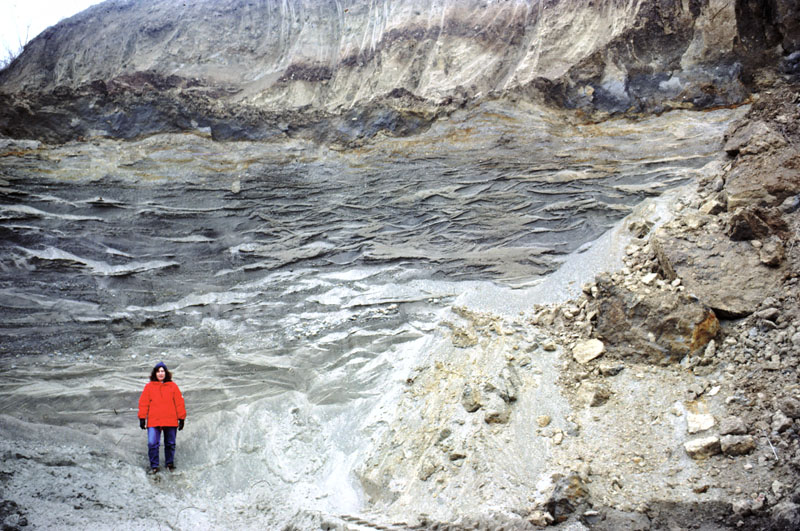 Figure 9.
A large body of slightly gravelly sand (light gray) underlying thin, sandy loam till (dark colored). Borrow pit along Indiana SR 3, Perry Township, northern Allen County.
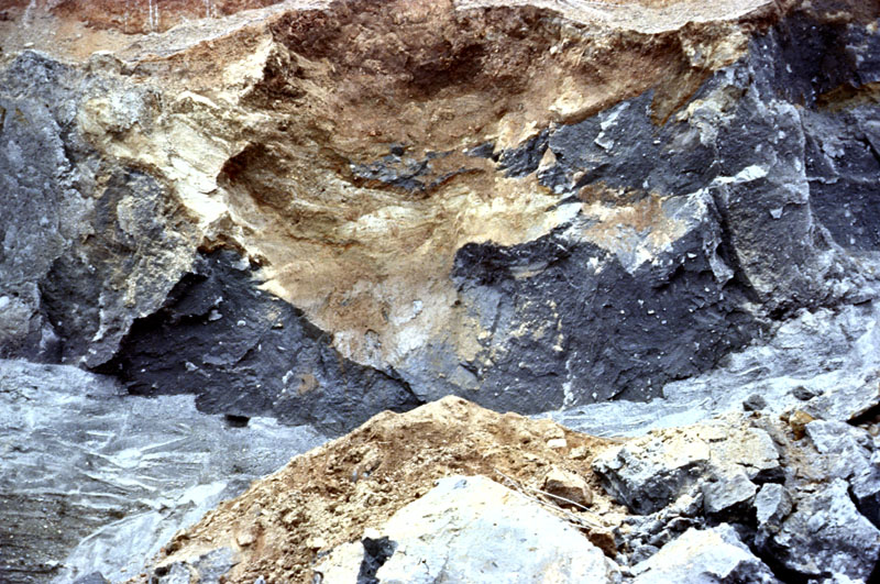 Figure 10.
A section of the Huntertown Formation with dimensions of the field of view approximately 30 ft wide by 20 ft high.
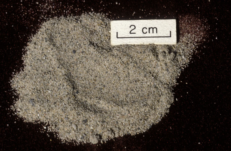 Figure 11.
Fine to medium-grained lacustrine sand at the distal edge of the Huntertown Formation. Collected from well drilled into the large sand unit underlying the Harlan area, Springfield Township, northeastern Allen County.
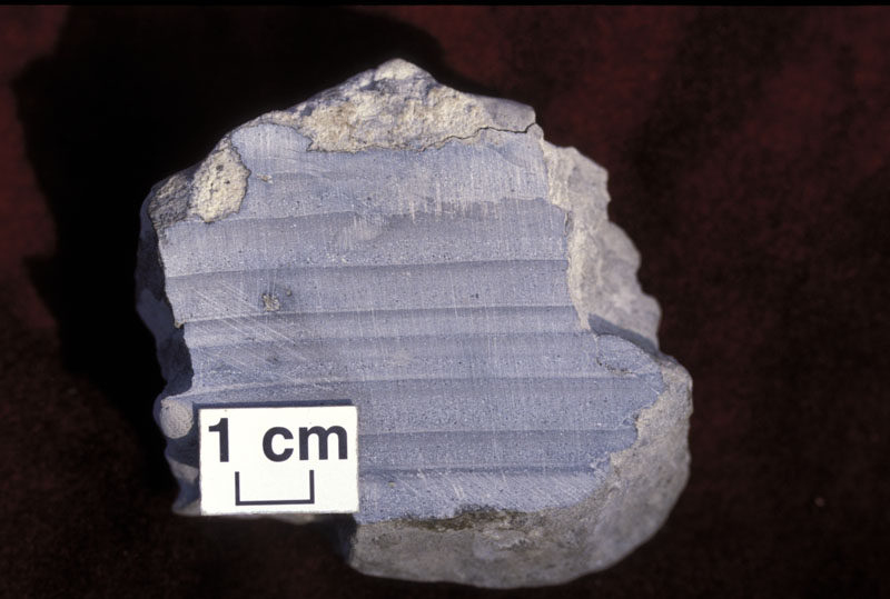 Figure 12.
Rhythmically layered graded beds in lake sediment underlying the Lagro Formation in the Maumee Lake Plain. These sediments were deposited from turbidity currents during the Erie Interstadial. Each bed consists of a lower, light-colored section of fine-grained sand and silt, grading up into the dark silty clay at the top. The sandy base of the next overlying bed is in sharp contact with the underlying bed. Woodburn Quarry, Maumee Township, eastern Allen County.
Lagro Formation
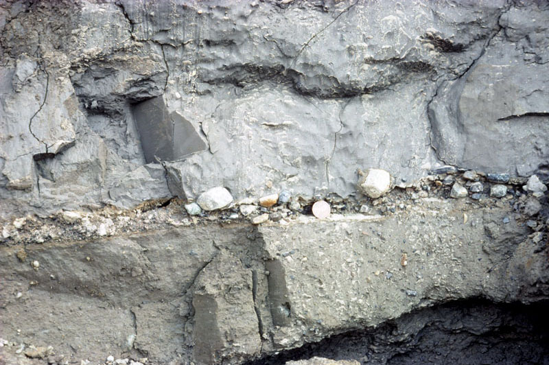 Figure 13.
Two till units of the Lagro Formation separated by a 1 to 2 in. layer of pebbles and sand. The upper unit is silty clay, the lower unit is clay loam and contains slightly more pebbles. Stone Street Quarry, Marion Township, southern Allen County.
The Lagro Formation (Wayne, 1963) encompasses the extensive group of clay-rich tills and
These distinctly different textures are thought to reflect two different periods of ice advance, separated by a minor retreat of the ice front prior to a readvance to the Wabash Moraine. The hiatus was evidently of sufficient length to enable a proglacial lake to develop in the Erie Basin and begin accumulating silt and clay, which were picked up and incorporated into the ice when it readvanced. Large bodies of strongly deformed silt and clay are common at the base of the sequence (fig. 14).
Most of the Lagro consists of massive basal till (fig. 15) that contains relatively few large clasts, exhibits a strong microfabric produced by parallel orientation of sand grains and sheared lenses of silt and clay, and is pervasively fractured (fig. 16).
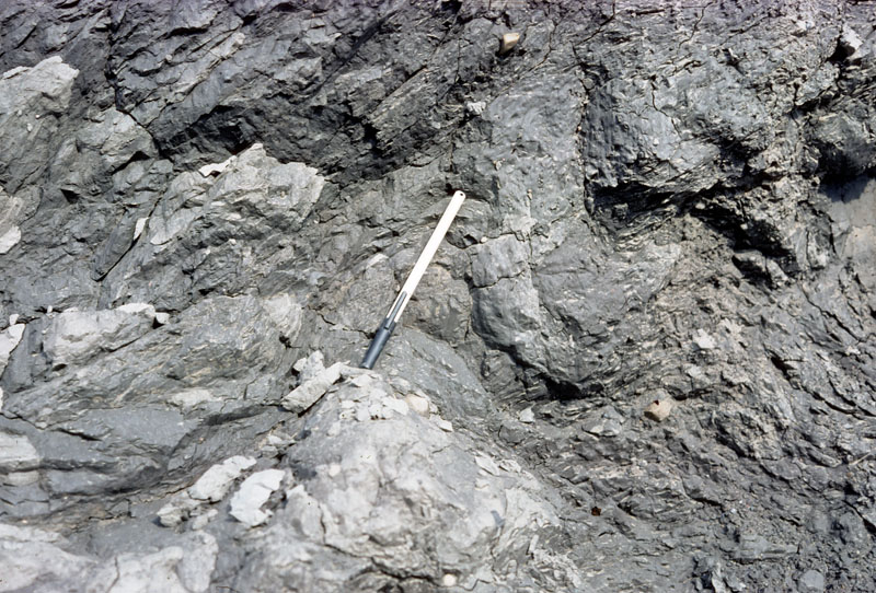 Figure 14.
Contorted unit of silt and sand under basal till of the Lagro Formation. The sediment was deformed as the ice overrode it. Stone Street Quarry, Marion Township, southern Allen County.
Most of the fractures occur in two near-vertical sets oriented at 60-degree angles to the local direction of ice flow, which is generally in a westward direction (Fleming, 1994a). This conjugate
relation to the direction of principal stress suggests that the fractures are the result of
This is thought to reflect the variable bed conditions produced as the Erie Lobe attempted to override obstructions produced by preexisting hummocky topography and large blocks of stagnant ice as it climbed a sharp regional slope north of the Wabash Moraine and Eel River (Fleming, 1994a; 1998a, b).
The fine-grained Lagro tills are the main soil-forming parent material in most of the county, and they serve as the principal confining unit that protects underlying aquifers. The unit has a dual
porosity: the fine-grained matrix exhibits very low
The fracture surfaces are characteristically encrusted with
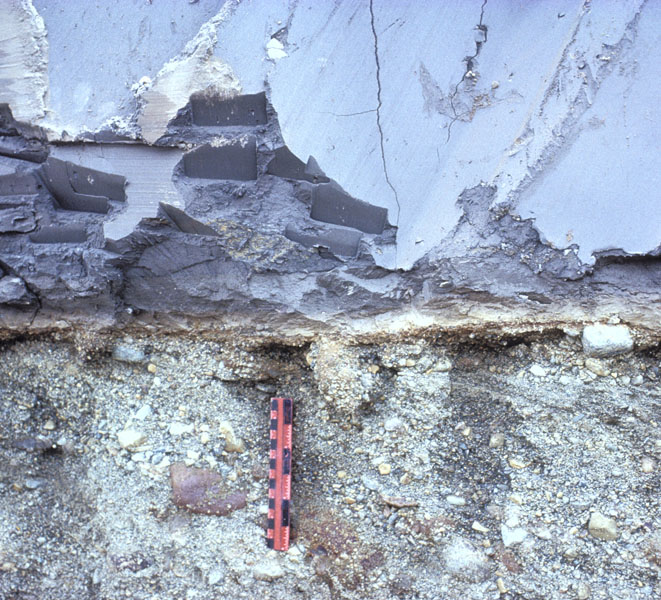 Figure 15.
Very clayey till of the Lagro Formation overlying sandy gravel. The gravel beds dip to the right (west), parallel to the flow direction of the meltwater that deposited them. The ruler for scale is 6 in.; StoneCo Quarry, Aboite Township, southwestern Allen County.
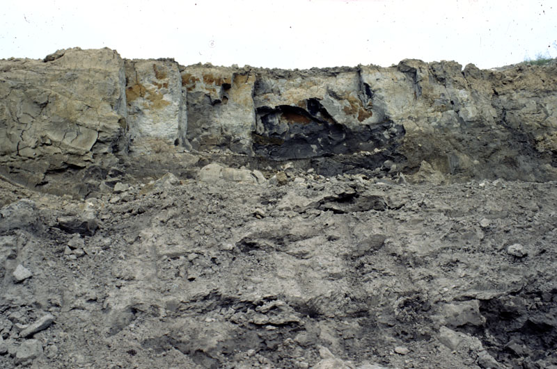 Figure 16.
 Sets of large fractures in basal till of the Lagro Formation with the field of view approximately 20 ft wide by 15 ft high. One set of joints forms the broad, flat, gray surfaces subparallel to the photo, the other set is oriented toward the viewer. The two sets intersect at 60 and 120-degree angles about the local direction of ice flow. The surfaces of the joints are encrusted with groundwater deposited gypsum; some surfaces are stained with oxides of iron (orange) and manganese (black). Stone Street Quarry, Marion Township, southern Allen County.
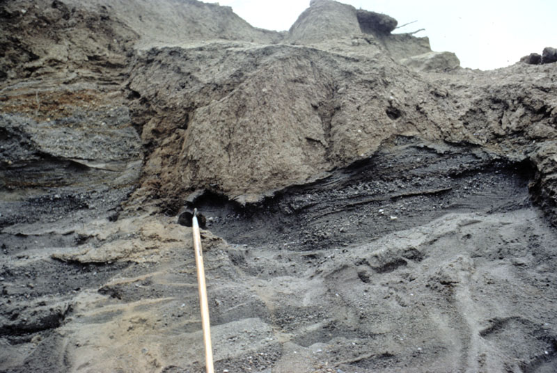 Figure 17.
Irregular mudflow and muddy outwash exposed on the side of a hummock, Lagro Formation, Eel River Township, northwestern Allen County.
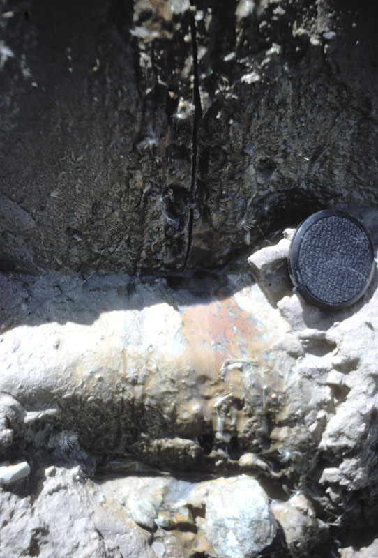 Figure 18.
 Water seeping from an open fracture in the Lagro till. The iron staining is produced when iron dissolved in the ground water under reduced conditions is exposed to the atmosphere and is oxidized. The iron probably is derived from dissolution of pyrite in the till. Aboite Creek, Aboite Township, southwestern Allen County.
Outwash
 Figure 19.
 Photograph showing steeply dipping and faulted beds at the head of a large outwash fan composed of sandy gravel. The ice front off of which the sediment was deposited lay just to the right of the photograph. Klink Sand and Gravel, Steuben County.
Sizable deposits of sandy and gravelly
These surficial outwash bodies are part of the Lagro Formation, and tend to be relatively thin, generally less than 50 ft thick. Though thin, these bodies are typically water saturated to within
10 ft or less of the land surface, and are in
 Figure 20.
 Photograph showing slightly mucky surface of the Cedar Creek outwash fan near the Eel River Valley, Perry Township, northern Allen County.
Postglacial History and Deposits
Following the retreat of the Erie Lobe, portions of the landscape were dotted with melting blocks of ice of various sizes, especially in the northwest part of the county, where the disappearance of these blocks created numerous depressions. Small lakes, swamps, and marshes developed in the depressions, eventually leading to the accumulation of various thicknesses of organic sediments (map unit p), chiefly sandy and silty muck, and sedge peat (fig. 21).
Similar wetland environments developed in abandoned meltwater channels and low-lying parts of plains (the Eel River Valley and parts of unit Lts in western Allen County). Such depressional wetlands were abundant
when the first European settlers arrived here, but most were drained to make way for agriculture. Groundwater beneath depressional wetlands in and around the hummocky interlobate area and Eel Valley of northwest
Allen County exhibit distinct geochemical signatures and strong downward
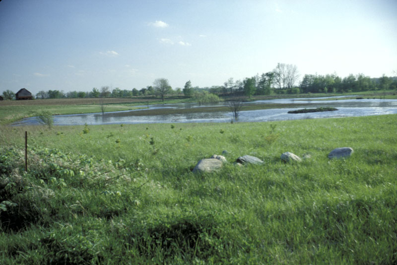 Figure 21.
 Photograph showing water standing in a small depressional peat bog following a heavy rain. Eel River Township, northwestern Allen County.
The signal event in the immediate postglacial landscape of Allen County, however, was the development and catastrophic collapse of Glacial Lake Maumee (Dryer, 1889; Leverett and Taylor, 1915; Bleuer and Moore, 1972, 1978). The lake formed between the retreating front of the Erie Lobe and the Fort Wayne Moraine, and at its maximum extent is thought to have held a volume of water comparable to or larger than modern Lake Erie. The bed of the old lake is essentially level and blanketed by stratified lake muds up to 15 ft thick (map unit Ltl); the mud was derived from meltwater debouching from the retreating ice margin and by waves whipping up sediment off the shallow parts of the lake and depositing in deeper parts of the lake below wave base. The margins of the lake are marked by small beach ridges, bars, and spits (map units b and s) composed chiefly of fine- to medium-grained sand, with some coarse sand and fine gravel. The largest beach ridge now serves as the route of SR 37 between I-469 and Hicksville, Ohio. Old Lincoln Highway (US 30) follows a smaller set of beach ridges along the south margin of the lake. The bluff at the southeast corner of the intersection of I-469 and US 30 offers a commanding view eastward across virtually the entire portion of the lake plain in Allen County.
Perhaps owing to a minor readvance of the ice front, the lake overtopped a sag in the moraine near what is now downtown Fort Wayne, causing a catastrophic outburst of water known as the
 Figure 22.
 Photograph showing the same peat bog several day
Indiana Geological and Water Survey Home Page
