
Age:Silurian Type designation:Type locality: The Cabot Head was originally named "the Cabots Head beds" by Grabau (1913) for exposures at Cabots Head on Manitoulin Island in northern Lake Huron, Ontario (Rexroad, 1986). History of usage:Revised rank: This unit later was designated the Cabots Head Shale Member and was assigned, along with the Manitoulin Limestone Member and the Whirlpool Sandstone Member, to the Cataract Formation by Schuchert (1914) (Rexroad, 1986).
Description:As recognized by Rexroad (1980) in its northeastern Indiana extent, the Cabot Head Member of the Cataract Formation consists of varying amounts of shale, dolomitic shale, and shaly to argillaceous dolostone ranging from intimate intermixtures to dominance by one lithology (Rexroad, 1986). The dolostone is generally fine grained, but lenses of coarser fossiliferous rock are present in some places; chert is recognized in a few sections (Rexroad, 1986). Although color varies, the rocks generally have a greenish cast. The member ranges from zero to slightly more than 60 ft (17 m) in thickness (Rexroad, 1986).
Boundaries:The Cabot Head is overlain unconformably by the Stroh Member of the Cataract, a unit of similar lithology (Rexroad, 1986). The basal bed of the Stroh, however, is commonly a tannish, very fine grained laminated dolostone that serves as a marker (Rexroad, 1980). Correlations:The Cabot Head of Indiana is continuous with the Cabot Head of Michigan; it does not include rocks as young as the Dyer Bay and the Wingfield of the Manitoulin Island area, northern Lake Huron (Rexroad, 1986). In Indiana it is in a facies relationship with the upper part of the Brassfield Limestone but generally pinches out east of the area of recognition of the Sexton Creek Limestone, although it is time correlative with part of the Sexton Creek (Rexroad, 1986). The Cabot Head contains conodonts of the Distomodus kentuckyensis Assemblage Zone, and in terms of British terminology, is approximately middle Llandoverian in age (Rexroad, 1980) (Alexandrian in the North American standard). |
|
Regional Indiana usage:
Kankakee Arch (COSUNA 14)
Misc/Abandoned Names:None Geologic Map Unit Designation:Scch Note: Hansen (1991, p. 52) in Suggestions to authors of the reports of the United States Geological Survey noted that letter symbols for map units are considered to be unique to each geologic map and that adjacent maps do not necessarily need to use the same symbols for the same map unit. Therefore, map unit abbreviations in the Indiana Geologic Names Information System should be regarded simply as recommendations. |
COSUNA areas and regional terminologyNames for geologic units vary across Indiana. The Midwestern Basin and Arches Region COSUNA chart (Shaver, 1984) was developed to strategically document such variations in terminology. The geologic map (below left) is derived from this chart and provides an index to the five defined COSUNA regions in Indiana. The regions are generally based on regional bedrock outcrop patterns and major structural features in Indiana. (Click the maps below to view more detailed maps of COSUNA regions and major structural features in Indiana.) 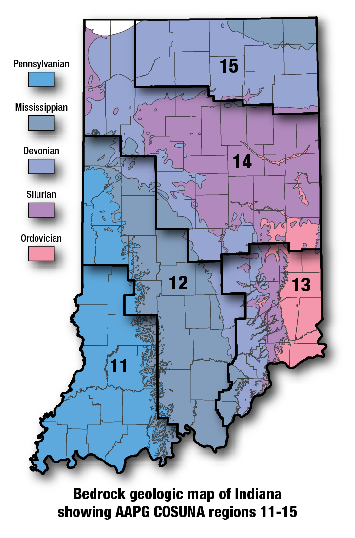
COSUNA areas and numbers that approximate regional bedrock outcrop patterns and major structural features in Indiana. 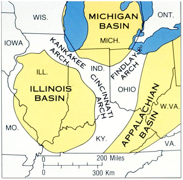
Major tectonic features that affect bedrock geology in Indiana. |
See also:
Brassfield Limestone
References:Grabau, A. W., 1913, Early Paleozoic delta deposits of North America: Geological Society of America Bulletin, v. 24, p. 399–528. Hansen, W. R., 1991, Suggestions to authors of the reports of the United States Geological Survey (7th ed.): Washington, D.C., U.S. Geological Survey, 289 p. Liberty, B. A., and Bolton, T. E., 1971, Paleozoic geology of the Bruce Peninsula area: Canada Geological Survey Memoirs 360, 163 p. Schuchert, Charles, 1914, Medina and Cataract Formations of the Siluric of New York and Ontario: Geological Society of America Bulletin, v. 25, p. 277–320. Shaver, R. H., coordinator, 1984, Midwestern basin and arches region–correlation of stratigraphic units in North America (COSUNA): American Association of Petroleum Geologists Correlation Chart Series. |
|
For additional information, contact:
Nancy Hasenmueller (hasenmue@indiana.edu)Date last revised: February 12, 2016
