

Project Overview
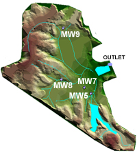
For the Midwestern Project Extension, water samples were obtained from four monitoring wells and the outlet of the final collection pond.
In February 1999, the Indiana Geological Survey reported on a project titled "Hydrology and Water Quality Associated with the Midwestern Reclamation Site (Site No. 1087), Pike County, Indiana." Later that year, the Indiana Division of Reclamation entered into an agreement with the Indiana Geological Survey, referred to as the "Midwestern Project Extension," to continue hydrological and hydrochemical investigations at the Midwestern Site through December 2001. The goals of the project extension were:
- To continue to monitor groundwater hydrology in the central lowland area where coal-combustion byproducts were utilized as structural fill (ash) and capping material (fixated scrubber sludge, FSS), and thereby evaluate the efficacy of the FSS cap as a barrier to the recharge of underlying coal refuse and ash;
- To continue to monitor the chemistry of ground water and surface water in order to identify trends in water quality, with particular emphasis on evaluating trends in concentrations of alkalinity and trace elements;
- To undertake statistical studies of trace-element concentrations in order to determine whether a sufficiently large number of samples have been collected to confidently establish average concentrations of selected trace elements;
- To create three-dimensional animations of the site that illustrate the geology of the site and how reclamation was engineered.
Principle Findings
The FSS continues to serve as an effective barrier to recharge:
- Soil-moisture profiles show large fluctuations of moisture content in the soil layer above the FSS cap, but virtually no change within the FSS itself.
- Ground water is perching at the top of the FSS layer during and immediately following major recharge events.
- Statistical analysis of water-level fluctuations in the pyritic refuse that underlies the FSS indicates that virtually all of the variability in water levels can be attributed to changes in atmospheric pressure. This indicates that the aquifer in the buried refuse is no longer being vertically recharged and is now behaving like an ideal confined aquifer.
Ground water has not yet achieved a steady-state chemical equilibrium. Some trace-element concentrations remain below their detection limits, but many of those that are above their detection limit are fluctuating. Concentrations of some trace elements in the ash used as fill show evidence of an upward trend. In contrast, the concentrations of trace elements in the buried pyritic refuse exhibit smaller fluctuations, and the concentrations of some of the elements seem to be trending downward over time.
Surface water that is discharged from the site has not yet achieved a steady-state chemical equilibrium, and some of the improvements noted in the previous report (February 1999) have been lost:
- Concentrations of arsenic, lead, and selenium in stream flow remain below the detection limit. But concentrations of nickel, cadmium, chromium, copper, and molybdenum continue to fluctuate through time. Only the concentration of boron appears to be approaching a steady-state value.
- Stream flow collected during two summer storms in 2001 have pH values that are consistently less than 4, and titrations indicate that the outflow no longer contains any alkalinity. This is probably because the agricultural lime that was spread over the surface during reclamation is depleted.
- During a storm on June 21, 2001, concentrations of trace elements in outflow from the site decreased somewhat, compared with concentrations immediately preceding the onset of rain. However, the concentrations that were observed in the storm flow exhibited random fluctuations that are indicative of a nonequilibrium condition. )
Statistical analyses of trace-element concentrations in ground and surface waters indicate that in many cases the number of samples collected to date (normally 20 or less) are insufficient to quantify the mean concentrations with any certainty. In most instances, a large standard deviation relative to the average value causes the uncertainty to be great. The large standard deviations reflect the fluctuating concentrations that occur because insufficient time has passed for the waters to have approached a steady-state equilibrium.
A three-dimensional analysis of the distribution of waste and capping materials on the site indicates that the pyritic coal refuse is effectively encapsulated between impermeable shale bedrock and FSS. A geophysical survey using terrain conductivity and magnetometry indicates that the plume of contaminated water associated with the pyritic refuse is also effectively isolated from further recharge and there is no indication that any of the acid water in the refuse is finding its way to the site outlet. A three-dimensional animation was created that illustrates these relationships. The animation, which is 63 Mb in size, is available upon request.
Credits
Hydrology and chemistry discussion: Greg Olyphant and Tracy Branam
Field operations: Jack Haddan, Shawn Naylor, Dana Cannon, Curtis Thomas, Greg Olyphant, and Tracy Branam
Chemical analyses: Margaret Ennis, Ron Smith, Tracy Branam, Sarah Butler, Patricia Renton, Jennifer Ward, Lisa
Welp, and John Comer
3D animation: Kevin Spindler
Macromedia Flash Animation, and report design and preparation: Denver Harper
Additional Information
For additional information, contact:
- Greg Olyphant (e-mail: olyphant@indiana.edu) at the Department of Geological Sciences, Indiana University, Bloomington, IN 47405
- Tracy Branam (e-mail: tbranam@indiana.edu) at the Indiana Geological Survey, 1001 E. 10th St., Bloomington, IN 47405
- Denver Harper (e-mail: dharper@indiana.edu) at the Indiana Geological Survey, 1001 E. 10th St., Bloomington, IN 47405-1405