

The movement of glaciers across Indiana dramatically altered the landscape. Although less dramatic, modern geologic processes continue to shape the land. Three of the more active types of processes are earthquakes in the lower Wabash and Ohio River valleys, stream and river erosion, deposition, and meandering throughout the state, and shoreline erosion and deposition along the Indiana's coast with Lake Michigan. Commonly these processes are termed "geologic hazards." But as we will see for the northwestern part of the state, what we call hazards today are processes that have acted on the shoreline for many thousands of years.
Glacial Retreat and Early Lake Michigan
About 14,000 years ago, the glacier that occupied Lake Michigan (Lake Michigan lobe) began to pull back from a large
arcuate highland that flanked the southern part of the lake basin. This highland consists of glacial
Distant Contact
Continued retreat of the Lake Michigan ice lobe from the Michigan basin opened outlets across Canada that rapidly lowered the elevation of the lake. The first time this happened was about 12,200 years ago. This time of low lake level is known as the Two Creeks Phase, and it ended about 11,800 years ago when ice readvanced into the basin. The readvance closed the Canadian outlets, ponding water in front of the ice once again. In the southern part of the lake, the rising lake level and accompanying waves and currents scoured sediment from the margins of the lake. This sediment was transported by longshore currents to northwestern Indiana. Here, it accumulated by waves and winds into the Calumet Beach (see map to the right). The Calumet Beach is a prominent feature along Indiana's coast. Highway 12 follows it from Michigan City to Dune Acres. Farther westward, Ridge Road follows the Calumet Beach through Glen Park, Highland, and Munster.
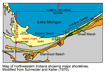
About 10,000 years ago, lake level rapidly fell again. It fell so quickly that nearshore bars are preserved in Wicker Park (intersection of Ridge Road and Highway 41). Like the fall 2,000 years earlier, this fall occurred as glacial ice retreated into Canada, opening an outlet across Canada into the St. Lawrence Seaway. Glacial ice would never return to Lake Michigan. This time of low lake level is know as the Chippewa Phase of ancestral Lake Michigan, and the elevation of the lake may have been more than 100 feet lower than today.
Moving in on Today
The Chippewa Phase lasted for about 4,000 years! Anyone standing on the shore of modern Lake Michigan could have looked northward and not seen water. Not only would they have not seen water, but it would have been more than a 5-mile walk for a drink.
The level of the water in the lake, however, was on the rise. By 8,300 years ago, it had drowned oak trees about 9 miles north of the modern coast. And by 6,300 years ago, the elevation of the lake was near its current position. The water continued to rise more than 20 feet higher than today by 5,500 years ago. The rising water was probably caused by two concurrent phenomena. One is a process called isostatic rebound. Isostatic rebound is an uplift of the earth's crust after a weight has been removed. In the Great Lakes area, the weight was the glacial ice. But now that the ice is gone, the crust is popping back up. In Hudson Bay, the rate of rebound is greater than an inch per year! The rebound more than 6,000 years ago elevated the outlets draining across Canada so that flow had to be redirected southward, following the current pattern of Great Lakes drainage.

The other reason for rising water levels is that the climate may have been cooling down from a warm and dry period (10,000 to 6,000 years ago) called the Hypsithermal. Think of it as the dust-bowl days on steroids -- hot and dry. Lake level in Lake Michigan is a mirror image of temperature. When temperature is high, there is less rainfall and more evaporation from the lake (see graphs to the right). Lake level falls. When it is cool, there is an increase in precipitation and a reduction in evaporation. Lake level rises. It is possible then that coming out of the Hypsithermal there was increased precipitation and less evaporation across the basin. This would have caused lake level to rise.
Whatever the actual cause, 5,500 years ago lake level stood 23 feet higher than today. Gary, East Chicago, the northern part of Hammond, Miller, Ogden Dunes, Dune Acres, Beverly Shores and the north part of Michigan City were under water. Of course they were not there then because the Toleston Beach had not yet been created. That, however, is the rest of northwestern Indiana's story.
Where's the Beach?
About 5,500 years ago, the level of the water surface in Lake Michigan was about 23 feet higher than today. At that time, the
southern shore of Lake Michigan was in the early stages of forming the last of Indiana's shorelines—the Toleston Beach.
In fact it is still in the process of making the Toleston Beach, today. Most people think of the Toleston Beach as the
"Indiana Dunes." The Indiana Dunes, however, is only the area of the coast where there are high dunes. This area
primarily runs from east of Michigan City westward to a little past Ogden Dunes. West and south of Ogden Dunes, the Toleston
Beach fans out into more than 100 individual
Let's look at the development of the Toleston Beach in two areas. First, by following the creation of the Indiana Dunes and Great Marsh in the eastern part of the Toleston Beach, and second, by looking at the addition of beach ridges in the western part.
Creating "da Dunes"
The development of what is now called the Indiana Dunes began while lake level was still rising from the Chippewa low. A hiatus or even a short-term fall during the rise about 6,500 years ago permitted a linear ridge of sand to accumulate along the Indiana shore (see diagram to the right). This barrier beach formed a little farther off the position of the modern shore and migrated landward through time. This migration was caused by storms that forced waves to overtop the early Toleston Beach and deposit sand and gravel behind the beach in a lagoon. The lagoon formed in the low area between the new Toleston Beach and the abandoned Calumet Beach. Not only did the waves bring sand and gravel into the lagoon, but mud and silt came along with the waves. These sediments would settle out of the water during fairweather conditions, creating layers mud and silt. Some of these deposits are exposed today along the shoreline at Mt. Baldy.
As the Toleston Beach continued to migrate landward, it grew in height with the addition of dune sands. Eventually, the Toleston Beach stabilized in one position when lake level stopped rising. The beach, at this time, was too high for waves to overtop it (see second image in cross section above). The lagoon landward of the beach began to dry up and to separate into individual ponds. These ponds had so little sediment coming into them that they precipitated calcium carbonate (marl). Precipitating marl was not hard to do, because waters draining the glacial highlands were probably saturated with respect to calcium carbonate and a calcium carbonate loving plant was around (Chara) to provide some additional input when it died.
The Toleston Beach and Great Marsh remained in this state until about 4,500 years ago. Lake level rapidly fell at this time to levels not unlike those observed in the historical record. This fall exposed large parts of the Toleston shore and significant quantities of sand were blown landward forming large Toleston Beach dunes. Many dunes were active at this time, migrating landward into Great Marsh. The Great Marsh was also changing. The marl ponds disappeared and vegetation colonized across the entire area between the Calumet and Toleston Beaches (see the third image in the cross section above). The widespread colonization of the Great Marsh probably also helped by a drainage divide that was forming under the growing Toleston Beach. This divide permitted water to flow landward into the Great Marsh, making the Great Marsh wetter than when the marl ponds were there.
By 2,000 years ago, The Great Marsh had taken on a form similar to today. Ditching and farming in the late 1800s and early 1900s has altered this form. Research in the Indiana Dunes National Lakeshore is looking for ways to restore parts of the Great Marsh to pre-settlement conditions and functions.
Making Beach
While the Toleston Beach from Ogden Dunes to Michigan City was making dunes and the Great Marsh was changing from marl ponds
to a widespread peatland, the Toleston Beach west of Ogden Dunes was making new lakefront property. This lakefront property
was in the form of a barrier beach of sand that extended westward into Illinois (see first image in diagram to the right).
At the western end was an opening (Sag channel) that let water from ancestral Lake Michigan flow into the Chicago River.
Landward of the Toleston Beach was a shallow lagoon (Calumet lagoon) that also drained westward into the Sag opening. This
lagoon occupied the low area between the early Toleston Beach and the landward Calumet Beach. Internally, the western part
of the early Toleston Beach consisted of long linear sand ridges that paralleled the shoreline. Geologists call these deposits
By about 2,200 years ago, lake level had fallen and water could no longer exit through the Sag opening (see second image in the diagram above). Also at this time, the Calumet lagoon had shrunk in size to become the westward-draining Little Calumet River. The Little Calumet turned around at the Sag opening and drained back eastward into Lake Michigan in what is now called the Grand Calumet River. Throughout the central part of the Toleston Beach, beach ridges continued to form, adding 100 to 200 more feet of lakeshore with the creation of each ridge. Westward, however, sand spits developed off of a bedrock headland in Illinois. These spits began to extend southward toward Indiana's coast.
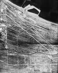
Aerial photograph (1938) of beach ridges in the Toleston Beach, just west of Gary. Each of the light-colored southeast- to northwest-oriented arcs is a former position of Lake Michigan's shoreline. The dark areas between ridges are wetlands.
Lake level was high in Lake Michigan about 1,700 years ago. This high stage caused erosion of the east and west margins of the lake. By 1,500 years ago, the sediment eroded from the western margin of the lake had formed a sand spit that extended off of the bedrock highland in Illinois and reattached farther south in Indiana (see third image in the diagram above). This spit trapped part of Lake Michigan behind it, creating early Lake Calumet. Most of the central part of Indiana's shore accepted the eroded sediment, and it was incorporated into more beach ridges. The addition of these beach ridges successively forced the mouth of the Grand Calumet River farther to the east.
This pattern of spit growth and beach-ridge development continued along the shore until man began to modify sediment transport patterns in the late 1800s and early 1900s. By the late 1800s the mouth of the Grand Calumet River had been driven more than nine miles (15 km) eastward across the Indiana shore to exit at Marquette, and the entire Toleston Beach shoreline had grown into the lake as much as 6 miles (9.5 km).
Today
Today, Indiana's coast is divided into individual cells of shoreline between man-made structures. Patterns of sediment transport that occurred along the shore starting about 6,000 years ago are interrupted by these structures. However, waves that attacked the shore thousands of years ago have modern counterparts that are still trying to move sediment along Indiana's coast. These waves and associated currents cause erosion downdrift of man-made structures because sediment that would have nourished the shore from updrift of the structure cannot get around it. In a sense, the waves, currents, and lake-level fluctuations that shaped Indiana's coast are today a geologic hazard.