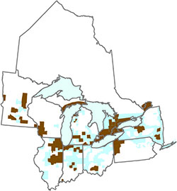
Why a geologic mapping coalition?
In the late 1990s, the state geological surveys of Illinois, Indiana, Michigan,
and Ohio joined with the U.S. Geological Survey to form the Central Great Lakes
Geologic Mapping Coalition. More recently, the Coalition has expanded to include
four additional states bordering the Great Lakes—Minnesota, New York, Pennsylvania,
and Wisconsin. These eight states have similar geologic conditions and must address
common societal issues about land and water resources, the environment, and geologic
hazards. By integrating their expertise and resources, the geological surveys are
addressing these issues more effectively than could any one agency.