
Age:Silurian Type designation:Type section: The name “Sexton Creek Limestone” was applied by Savage (1909) to Silurian strata above the Edgewood Limestone and below Helderbergian (Lower Devonian) rocks for exposures at the mouth of Sexton Creek in Alexander County in southwestern Illinois (Rexroad and Droste, 1986). History of usage:In the same report by Savage (1909), the Edgewood was defined as lying between the Girardeau Limestone (Lower Silurian) and the Sexton Creek (Rexroad and Droste, 1986). The Sexton Creek was later restricted (Ulrich, 1911) to approximately its present stratigraphic limits, and the overlying rocks now referred to the St. Clair Limestone were eliminated from the formation (Rexroad and Droste, 1986). The boundary between the Edgewood and the Sexton Creek has been variously defined (Rexroad and Droste, 1986). At present the brachiopod Platymerella manniensis is used in the type area in Illinois to characterize the basal beds of the Sexton Creek (Rexroad and Droste, 1986). As currently defined, the Sexton Creek is the precise equivalent of the Brassfield Limestone and is physically continuous with it, and so the junior name “Sexton Creek” serves only to designate conveniently a distinctive facies of the Brassfield (Rexroad and Droste, 1986). The name was first used in Indiana in 1974 by Becker (Rexroad and Droste, 1986). The Schweizer Member is present as a basal unit of the Sexton Creek in parts of northwestern Indiana (Rexroad and Droste, 1982; Rexroad and Droste, 1986). Description:Throughout most of the extent of the Sexton Creek Limestone in Indiana, exclusive of the Schweizer Member, the formation is an impure very cherty dolostone or limestone, but the chert commonly does not extend all the way to the top or the bottom of the formation (Rexroad and Droste, 1986). In places, chert constitutes 60 to 70 percent of the rock (Rexroad and Droste, 1986). Almost everywhere in Indiana the carbonate component is light to medium brown, although there is some gray banding and mottling (Rexroad and Droste, 1986). It is fine or medium grained and commonly granular but includes coarse lenses and beds, some of which are bioclastic (Rexroad and Droste, 1986). Irregular gray or brown shale partings are erratically present (Rexroad and Droste, 1986). The Schweizer is much more argillaceous and contains little or no chert (Rexroad and Droste, 1986).
Boundaries:The Sexton Creek unconformably overlies Ordovician rocks of the Maquoketa Group (Rexroad and Droste, 1986). It is overlain unconformably by the St. Clair Limestone in southwestern Indiana and by the Salamonie Dolomite elsewhere in the state, except in Lake County where the relationship is possibly conformable (Rexroad and Droste, 1986). Correlations:The Sexton Creek Limestone is recognized under that name in southeastern Missouri and southwestern Illinois (Rexroad and Droste, 1986). It is in a facies relationship with the Birds Member of the Wilhelmi Formation and with the Elwood and Kankakee Formations of northeastern Illinois (Rexroad and Droste, 1986). It is also in a facies relationship with the Manitoulin Dolomite Member and the Cabot Head Member of the Cataract Formation of northeastern Indiana and with the Brassfield Limestone of east-central and southeastern Indiana and in north-central Kentucky (Rexroad and Droste, 1986). In terms of conodont zones the Schweizer Member of the Sexton Creek belongs in the Panderodus simplex Assemblage Zone, and the rest of the Sexton Creek is in the Distomodus kentuckyensis Assemblage Zone (Rexroad and Droste, 1982; Rexroad and Droste, 1986). The latter approximates the middle Llandoverian part of the British standard Silurian sequence, but the Sexton Creek also includes rocks of late Llandoverian age where it merges with the Brassfield of southwestern Indiana (Rexroad and Droste, 1986). |
|
Regional Indiana usage:
Illinois Basin (COSUNA 11)
Misc/Abandoned Names:None Geologic Map Unit Designation:Ssc Note: Hansen (1991, p. 52) in Suggestions to authors of the reports of the United States Geological Survey noted that letter symbols for map units are considered to be unique to each geologic map and that adjacent maps do not necessarily need to use the same symbols for the same map unit. Therefore, map unit abbreviations in the Indiana Geologic Names Information System should be regarded simply as recommendations. |
COSUNA areas and regional terminologyNames for geologic units vary across Indiana. The Midwestern Basin and Arches Region COSUNA chart (Shaver, 1984) was developed to strategically document such variations in terminology. The geologic map (below left) is derived from this chart and provides an index to the five defined COSUNA regions in Indiana. The regions are generally based on regional bedrock outcrop patterns and major structural features in Indiana. (Click the maps below to view more detailed maps of COSUNA regions and major structural features in Indiana.) 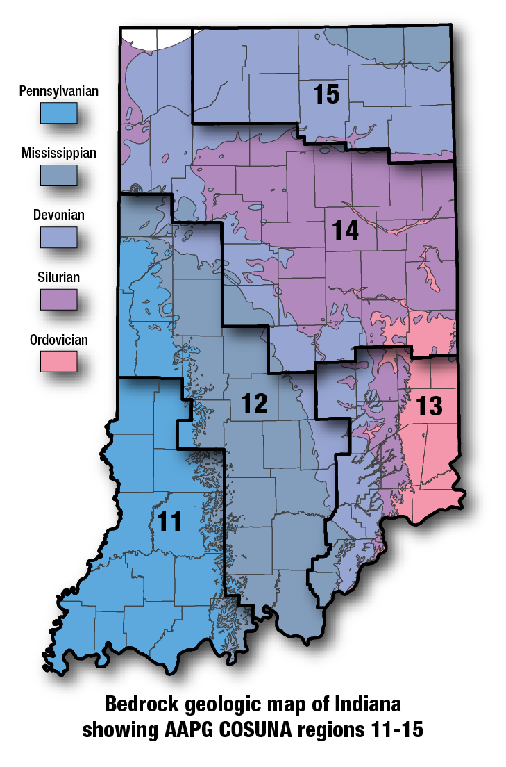
COSUNA areas and numbers that approximate regional bedrock outcrop patterns and major structural features in Indiana. 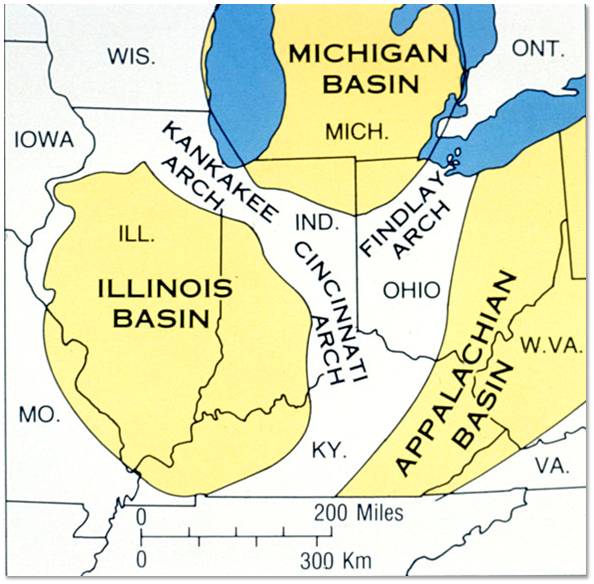
Major tectonic features that affect bedrock geology in Indiana. |
See also:
Brassfield Limestone
References:Hansen, W. R., 1991, Suggestions to authors of the reports of the United States Geological Survey (7th ed.): Washington, D.C., U.S. Geological Survey, 289 p. Savage, T. E., 1909, The Ordovician and Silurian formations in Alexander County, Illinois: American Journal of Science, ser. 4, v. 28, p. 509–519. Shaver, R. H., coordinator, 1984, Midwestern basin and arches region–correlation of stratigraphic units in North America (COSUNA): American Association of Petroleum Geologists Correlation Chart Series. Ulrich, E. O., 1911, Revision of the Paleozoic systems: Geological Society of America Bulletin, v. 22, p. 281–680. |
|
For additional information, contact:
Nancy Hasenmueller (hasenmue@indiana.edu)Date last revised: July 28, 2017
