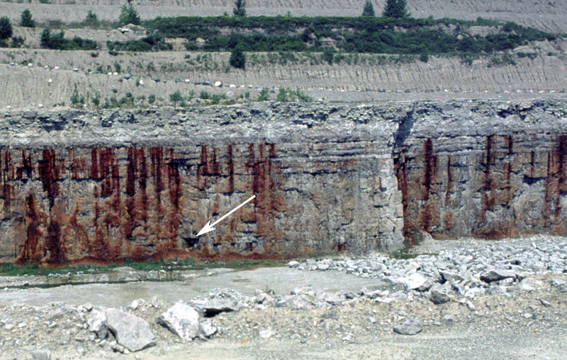
Figure 1.
Photograph of Devonian carbonates in a quarry in Allen County. Note solution feature.
The bedrock
surface, or topography, in Allen County is erosional in origin and the relief on the bedrock surface is approximately 200 ft. The bedrock is covered by
as much as 300 ft of glacial material in the northwestern part of Allen County; the glacial materials thin to the south and the bedrock is 60 to 80 ft
below the surface in a large part of southern Allen County. The preglacial landscape of much of Allen County would have resembled the present-day landscape
of the karst
areas found at or near the surface in southern and southeastern Indiana.
Although the buried bedrock surface cannot be directly observed, Fleming (1994) made the following inferences concerning the characteristics of the
subsurface bedrock landscape. The topography of the bedrock surface underlain by the relatively soft Antrim Shale
(Hasenmueller, 1986) forms a broad north- to northeast-sloping lowland cut by small northeast-trending valleys (Fleming, 1994). The parts of the bedrock
surface underlain by limestone
generally form a north-sloping dissected karst plain that is locally cut by narrow steep-sided valleys with 50 to 150 ft of relief. Relict
solution feature
such as sinkhole,
small caves, and enlarged joints
can be seen in quarry exposures throughout northeastern and north-central Indiana (Nowacki, 1991) (fig. 1). Most of the karst development probably occurred
well before glaciation. The two parts of the bedrock surface are generally separated by a gentle north-facing regional slope, which marks the changes from
the soft, easily eroded Antrim Shale to the north from the more resistant carbonate units to the south (Fleming, 1994).
References:
Fleming, A. H., 1994, The hydrogeology of Allen County, Indiana–a geologic and ground-water atlas: Indiana Geological Survey Special Report 57, 111 p.
Hasenmueller, N. R., 1986, Antrim Shale, in Shaver, R. H., and others, 1986, Compendium of Paleozoic rock-unit stratigraphy in Indiana-a revision: Indiana Geological Survey Bulletin
59, p. 5; Indiana Geological Survey Web page, date accessed March 8, 2007.
Hasenmueller, N. R., Powell, R. L., Buehler, M. A., and Sowder, K. H., 2002 [Copyright date], Karst in Indiana: Indiana Geological Survey Web page,
<https://igs.indiana.edu/Bedrock/Karst.cfm>,
date accessed March 21, 2007.
Nowacki, J., 1991, Karst on the buried Silurian surface in north-central Indiana and the impact on ground water: Proceedings of the Thirty-sixth Annual Midwest Ground Water Conference, Indianapolis, Indiana, p. 80-81.
 Figure 1.

