

Geologists drill holes into the rock underground for several reasons. Probably the greatest number of
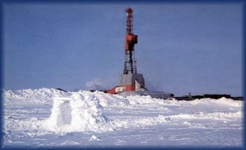
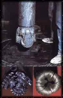
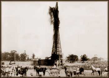
The first oil well was drilled in Pennsylvania in April 1858 by James M. Townsend and "Colonel" Edwin L. Drake. The drilling rigs in those days were about 40 feet (12 meters) tall and were made of wood. In the photo above (taken about 1890 in Jay County, Indiana), oil is "blowing out" from over the top of the derrick, which was a common occurrence throughout the early twentieth century. Today a large rig is 160 feet (49 meters) tall and made mostly of steel. The rigs are tall so that a drill bit of either hardened steel or diamonds can be put on the end of 90-foot (27 meters) lengths of drill pipe and lowered into the hole to drill the rock. The new rigs (photo to the right) have "blow out" preventers so that pressure of pockets of natural gas or other fluids will be contained within the well bore. In this way, oil is not lost and the environment is not contaminated. When a bit is dull, it must be pulled from the hole. The 90-foot sections of drill pipe are positioned standing up in the derrick until a new bit is screwed on the last length of pipe and then it is lowered back into the hole to continue drilling. Records for holes drilled for oil, gas, or minerals are available from the Indiana Geological Survey. Records for holes drilled for water are available from the Indiana Department of Natural Resources Division of Water.
The drill bit (photo to the right) breaks the rock into small fragments about the size of your little fingernail
or smaller; these pieces of rock are carried to the surface by water mixed with mud that is forced down the inside
of the pipe and comes up the outside, carrying the small chips of rock. A geologist can look at these chips under
a microscope and determine what kind of rock is being drilled. A core barrel is attached to the drill pipe to
replace the bit and lengths of rock are cut and recovered from the inside of the core barrel when it is pulled to
the surface. These
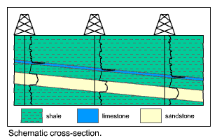
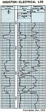
After a hole is drilled, geophysical measuring instruments are lowered on steel lines into the
mud- and water-filled hole. These instruments are then pulled up slowly and a paper log of the
measurements is produced. Characteristics of the rock such as its conductivity of electricity,
other electrical properties, its radioactivity (see
References
All illustrations except those of the old drilling rig, the cross section, and the road cut are from:
Baker, Ron; 1979; A Primer of Oilwell Drilling; The University of Texas at Austin; Austin, Texas.