

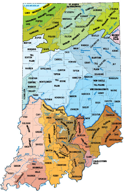
Figure 1. Physiographic divisions of Indiana (Gray, 2000). Click on the map to view enlarged map showing the physiographic divisions of southern Indiana. In south-central Indiana, karst features are present in the Mitchell Plateau and parts of the Crawford and Norman Uplands. In southeastern Indiana, karst is present in the Muscatatuck Plateau and Charlestown Hills physiographic divisions.
Introduction
Karst is a distinctive type of landscape or topography that commonly occurs where carbonate strata (limestones and dolostones) are at the surface. Slightly acidic rainwater and water in the soil slowly percolate through fractures, dissolving the rock and creating sinkholes, caves, and many other features that characterize karst. In arid locations, karst features can develop on soluble bedrock units such as gypsum or salt deposits (White, 1988).
Karst in Indiana
Southern Indiana has several well-developed areas of karst landscape. The Mitchell Plateau is a broad carbonate karst plateau dissected by a few major stream systems (Malott, 1922; Gray, 2000) (fig. 1). This plateau is developed on Mississippian carbonates and extends from the eastern part of Owen County southward to the Ohio River in Harrison County and into Kentucky. To the west, the Crawford Upland is characterized by ridges and valleys developed on shale, sandstone, and carbonate strata of Mississippian age. Sinkholes, karst valleys, and caves are common along the eastern margin of this physiographic division where carbonate units are present (Gray, 2000). Some karst features are also developed in carbonate strata along the western margin of the Norman Upland to the east of the Mitchell Plateau.
Other physiographic divisions that exhibit karst features are located in southeastern Indiana and are known as the Muscatatuck Plateau and the Charlestown Hills (Gray, 2000). These areas are developed on carbonate strata of Silurian and Devonian age.
Much of the northern two-thirds of Indiana is covered by unconsolidated Pleistocene glacial materials of varying thickness. In most areas of northern Indiana where carbonate rocks constitute the bedrock, karst features are not exposed at the surface but are buried. However, in some areas along the Wabash River the glacial materials are thin or absent and karst features are exposed at the surface.
Karst solution features
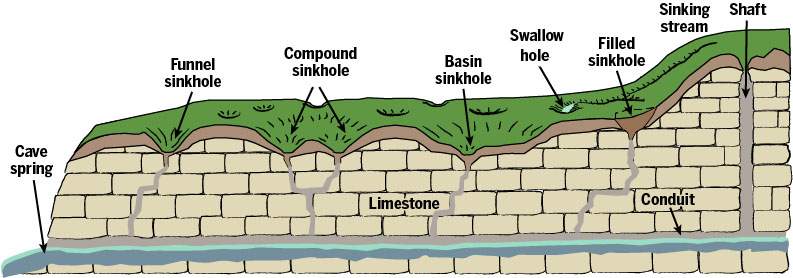
Figure 2. Solution features characteristic of karst terrains (Hasenmueller and Powell, 2005).
When carbonate rocks dissolve, distinctive solution features develop that are characteristic of karst terrains; the more common features are springs, sinkholes, caves, and sinking or disappearing streams (fig. 2) (Hasenmueller and Powell, 2005). Springs are places where subsurface water flows from rock or soil onto the land surface. Sinkholes form where the carbonates are dissolved and the soil layer on top falls into the resulting depression. Sinkholes may or may not have an apparent opening to underground drainage. Sinking or disappearing streams are surface streams in karst areas that flow directly into the groundwater system at a feature called a "swallow hole." Underground drainage systems, composed of solution-enlarged features, conduits, and caverns dissolved in the strata through which water may flow are common to karst areas. Surface streams in a karst area are generally short and lose their water during dry periods, but some sinking streams drain many square miles.
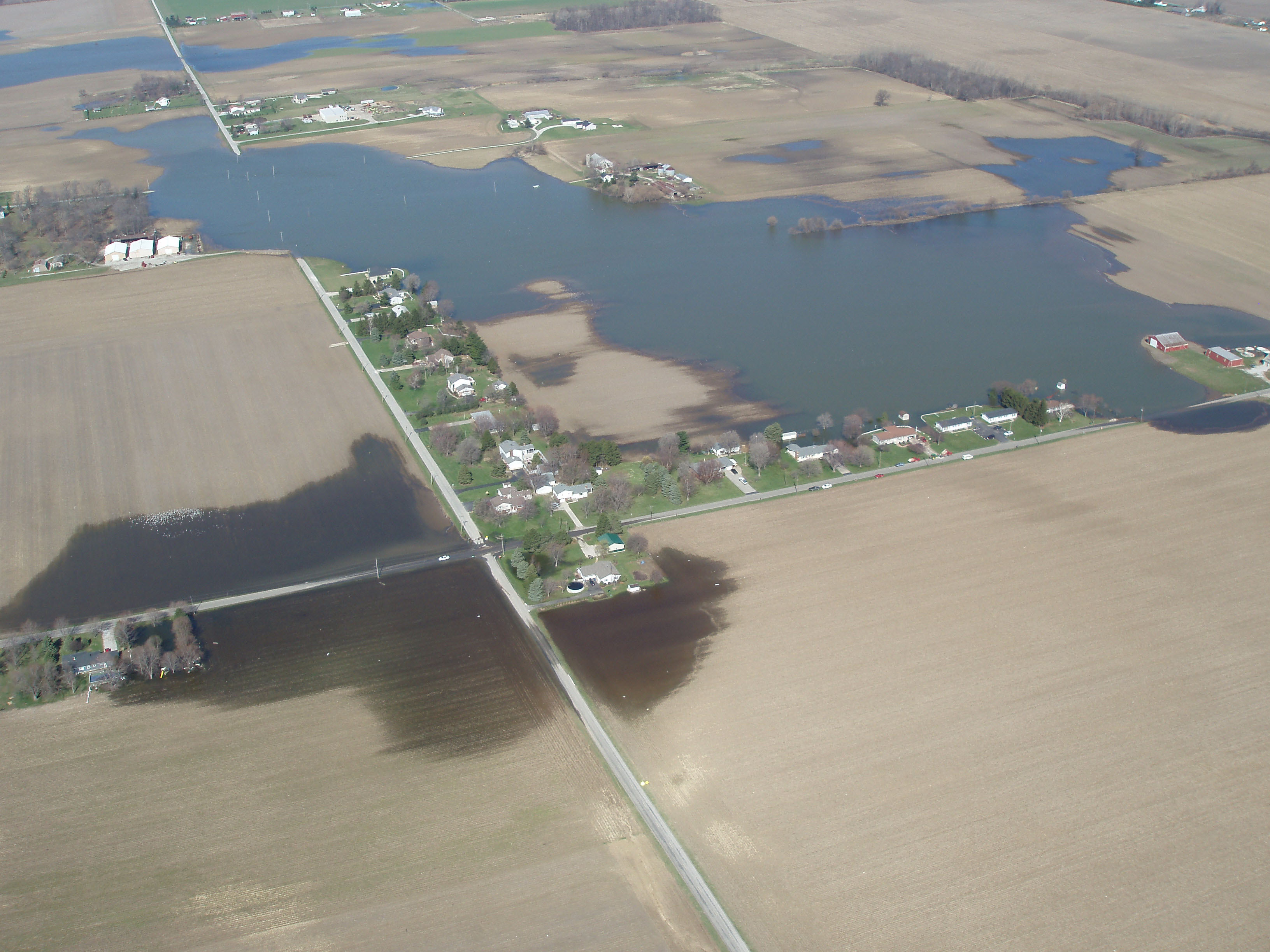
Figure 3. Extensive karst flooding was caused by a lack of surface drainage near Bellevue, Ohio. Surface and near-surface geologic conditions, combined with increases in precipitation, resulted in groundwater rising to the surface; flowing from existing sinkholes; and filling closed basins and sinkholes, caverns, and underground drainage passageways (Pavey and others, 2012). (Photograph courtesy of Douglas J. Aden.)
Karst hazards
Groundwater contamination: The uppermost or shallow groundwater in karst terrains can easily be contaminated because surface waters can move rapidly and flow directly into the subsurface at sinkholes and swallow holes (Hasenmueller and Powell, 2005). This water flows underground without the benefit of filtration by soil and bedrock or exposure to sunlight that might remove some organic contaminants. We can protect the karst environment by not disposing of trash in sinkholes. Also, we need to be aware of the proper use of insecticides, herbicides, and fertilizer to prevent contamination of the groundwater (Hasenmueller and Powell, 2005).
Drainage problems: Drainage problems can arise when the karst landscape is altered by building and development (Veni and others, 2006). Erosion caused by construction and the resulting transport of soil may clog sinkholes that normally drain surface waters. Subsequently, even smaller storms are capable of flooding the sinkholes and surrounding areas (fig. 3). The construction of impermeable surfaces, such as buildings and pavement, also increases the amount of water that flows on the surface. This can result in temporary flooding in the vicinity of a sinkhole that would normally be able to accept the entire discharge (Veni and others, 2006).
Collapse features: A sinkhole is a collapse feature. Scientists define a sinkhole as a closed or bowl-shaped depression that develops in karst. The term "sinkhole" has been incorrectly used by some to describe collapse features that are not karst in origin, such as depressions caused by subsidence over an abandoned underground coal mine or a washout of unconsolidated material caused by a broken water or sewer line.
Several incidents of sinkhole collapse in Florida recently were reported in the news. People wonder if something similar could happen in Indiana; however, there are some geologic and hydrologic differences between the karst and cavernous regions of Indiana and those of Florida. Many of the collapse sinkholes in Florida that effect buildings are in urban or suburban areas and were caused by leakage from water and sewer lines, swimming pools, and ponds. The drainage of this water through a semiconsolidated or poorly cemented sand formation overlying a cavernous carbonate unit results in the formation of sinkholes. Another issue in Florida is an extreme lowering of the water table related to drought conditions and excessive agricultural pumping; this results in the sediment in the sinkhole no longer being supported underneath. Rainfalls have collapsed these unsupported sediments.
The karst sinkhole areas in Indiana are developed on relatively well-cemented, dense carbonate formations. Most of the sinkholes in Indiana are obvious (fig. 4) and are not problems for construction unless a structure is sited on too steep a slope, or a sinkhole has been filled in without the builder's knowledge.
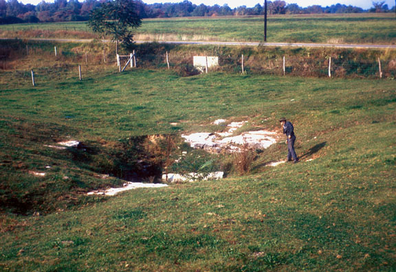
Figure 4. A sinkhole developed in Mississippian carbonate rock in Lawrence County, Indiana. (Photograph courtesy of Samuel S. Frushour.)
Exploring karst features in Indiana
A number of karst features in Indiana are easily accessed and can be explored. Spring Mill State Park near Mitchell is near the type locality of the Mitchell Plateau (Malott, 1922, p. 127). Caves, springs, and numerous sinkholes are some of the karst features that can be seen within the park.
In 2009, all caves and sinkholes on Indiana Department of Natural Resources (DNR) property, with the exception of Twin Caves at Spring Mill, and on federal property were closed to the public to curtail the spread of white-nosed syndrome, a fungus that has killed bats in large numbers in the northeastern, southeastern, and midwestern United States. In 2014, the Indiana DNR initiated a pilot program to allow limited access to select caves at Spring Mill State Park and Cave River Valley Natural Area. The program, in partnership with the Indiana Karst Conservancy, allows for recreational caving by groups on an interim basis.
McCormick's Creek State Park in Owen County is near the northern extent of the Mitchell Plateau. This park has several karst features including Wolf Cave, natural bridges, and a number of deep sinkholes (Frushour, 2012).
Cave River Valley Natural Area in Washington County is another karst area in the Mitchell Plateau physiographic division of Indiana. Its most noteworthy feature is its caves, some of which are bat hibernacula.
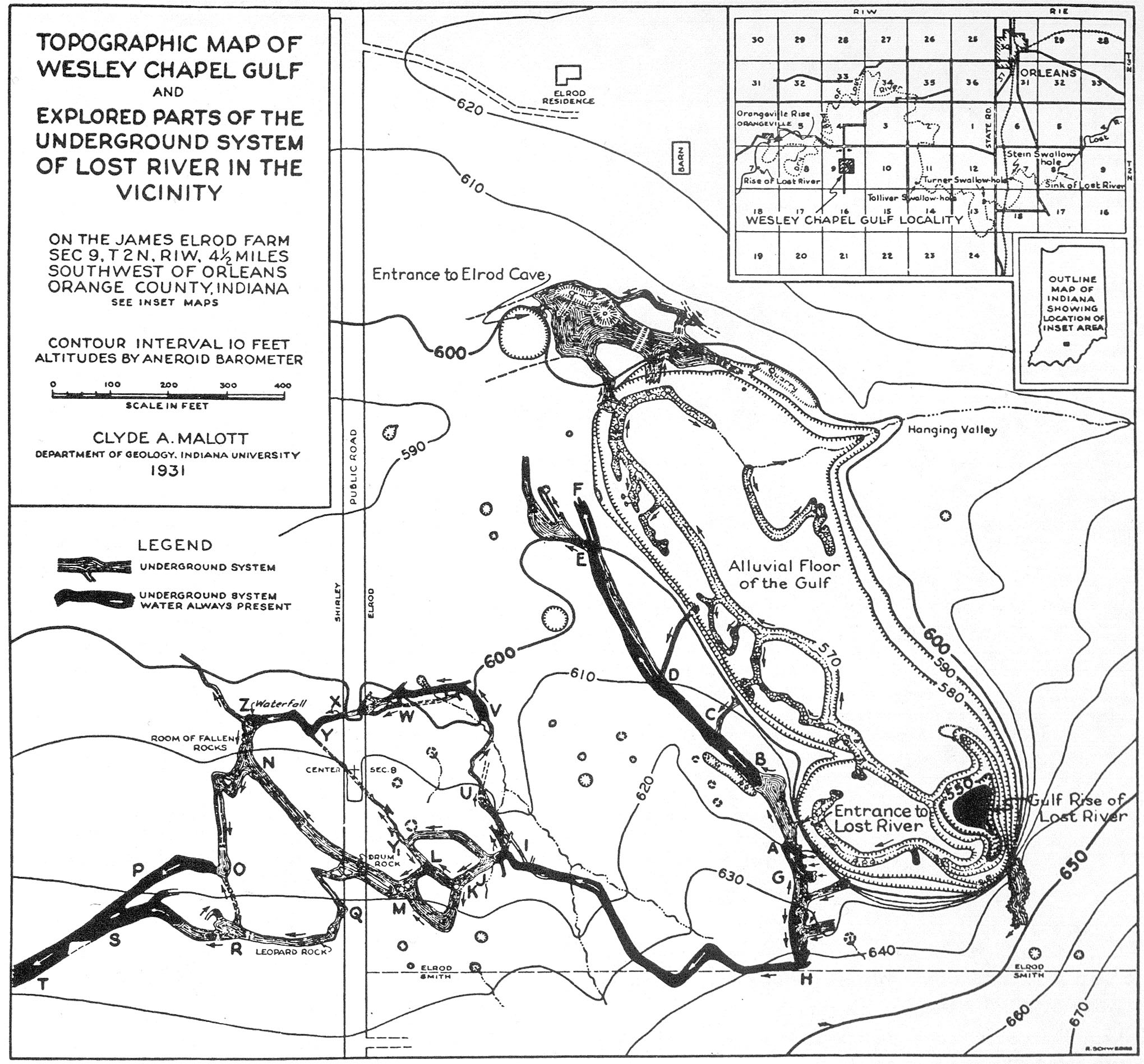
Figure 5. Wesley Chapel Gulf in Orange County, Indiana; sketch map originally drawn by Clyde A. Malott in 1931 (Malott, 1932).
Wyandotte Cave in Crawford County was designated a National Natural Landmark in 1972 and is now part of O'Bannon Woods State Park. The cave, located within the Harrison-Crawford State Forest, has more than 9 miles of explored passageways, huge rooms, vertical shafts, cave breakdowns, and speleothems. As of June 2010, Wyandotte Cave was closed indefinitely in an effort to protect the bat population against white-nose syndrome.
Privately owned show caves such as Marengo Cave, Bluespring Caverns, and Squire Boone Caverns remain open to the public for tours. More information about these caves can be found in A Guide to Caves and Karst of Indiana (Frushour, 2012). When visiting caves and other karst features always follow safety precautions. For more information about cave safety, visit the website "Caves–visiting caves and cave safety" (Frushour, n.d.).
The largest spring in Indiana, Harrison Spring in Harrison County is designated a National Natural Landmark. It is one of the best examples in the United States of an alluviated cave spring because of its location in an abandoned meander loop and the natural levee around its periphery (Powell, 1963).
The largest collapse feature in Indiana is Wesley Chapel Gulf in the Lost River area of Orange County. Located within the Hoosier National Forest, this National Natural Landmark is a large collapsed sinkhole; it is approximately 1,000 feet in length and averages 350 feet in breadth (Frushour, 2012). It is a steep-walled closed depression with a flat alluviated bottom (fig. 5). The feature encompasses about 10 acres and ranges from about 25 to 85 feet in depth (Hasenmueller and others, 2003).
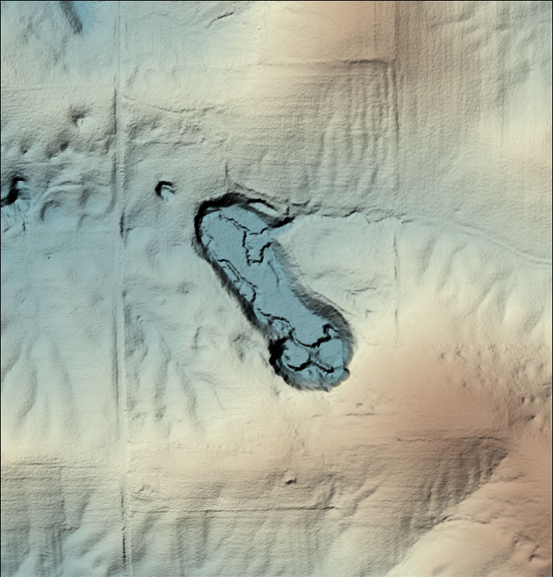
Figure 6. LiDAR color hillshaded image of Wesley Chapel Gulf in Orange County, Indiana, compiled using IndianaMAP (Indiana Geographic Information Council, 2013).
Using LiDAR and GIS to detect karst features
Airborne LiDAR (light detection and ranging) technology is used to create detailed computer representations of the land surface. Using LiDAR in karst areas is advantageous because of its ability to "see" through vegetation when mapping the land surface (Alexander and others, 2013). LiDAR can be combined with other geographically referenced maps and photos in a geographic information system to map landscape features (Alexander and others, 2013). The hillshaded LiDAR image of Wesley Chapel Gulf from the IndianaMAP website illustrates how distinct the karst features appear (fig. 6). One can view the distribution of karst features in our state using IndianaMAP at IndianaMAP karst features.
References
Alexander, S. C., Larson, E., Bomberger, C., Greenwaldt, B., Alexander, E. C., Jr., and Rahimi, M., 2013, Combining LiDAR, aerial photography, and pictometry tools for karst features database management: National Cave and Karst Research Institute Symposium 2, 13th Sinkhole Conference, p. 441-448.
Frushour, Sam, n.d., Caves - visiting caves and cave safety: Indiana Geological Survey website,
< http://igws.indiana.edu/Hazards/CaveSafety.cfm>, date accessed, December 1, 2014.
Frushour, S. S., 2012, A guide to caves and karst of Indiana: Indiana University Press, 142 p.; available at Geological Survey Bookstore, < https://igws.indiana.edu/bookstore/details.cfm?ItemID=2146&Pub_Num=MI110 >, date accessed, February 1, 2016.
Gray, H. H., 2000, Physiographic divisions of Indiana: Indiana Geological Survey Special Report 61, 15 p.; available at Indiana Geological Survey Bookstore,
< https://igws.indiana.edu/bookstore/details.cfm?ItemID=897&Pub_Num=SR61 >, date accessed, February 1, 2016
Hasenmueller, N. R., and Powell, R. L., 2005, Karst: Indiana Geological Survey Poster 04.; available at Indiana Geological Sujrvey Bookstore,
< https://igws.indiana.edu/bookstore/details.cfm?ItemID=1145&Pub_Num=POSTER04 >, date accessed, February 1, 2016.
Hasenmueller, N. R., Rexroad, C. B., Powell, R. L., Buehler, M. A., and Bassett, J. L., 2003, Karst geology and hydrology of the Spring Mill Lake and Lost River drainage basins in southern Indiana: Indiana Geological Survey Guidebook 15, 29 p.; available at Indiana Geological Survey Bookstore,
< https://igws.indiana.edu/bookstore/details.cfm?ItemID=1023&Pub_Num=GB15 >, date accessed, February 1, 2016
Indiana Geographic Information Council, 2013, IndianaMAP: Indiana Geographic Information Council website, < http://www.indianamap.org/about.php,> date accessed, December 1, 2014.
Malott, C. A., 1922, The physiography of Indiana, in Handbook of Indiana geology: Indiana Department of Conservation Publication 21, pt. 2, p. 59-256.
Malott, C. A., 1932, Lost River at Wesley Chapel Gulf, Orange County, Indiana: Indiana Academy of Science Proceedings for 1931, v. 41, p. 285-316.
Pavey, R. R., Angle, M. P., Powers, D. M., and Swinford, E. M., 2012, Karst flooding in Bellevue, Ohio, and vicinity-2008: Ohio Department of Natural Resources, Division of Geological Survey Map EG-5, scale 1:24,000.
Powell, R. L, 1963, Alluviated cave springs of south-central Indiana: Indiana Academy of Science Proceedings for 1962, v. 72, p. 182-189.
Veni, G., DuChene, H., Crawford, N. C., Groves, C. G., Huppert, G. N., Kastning, E. H., Olson, R., and Wheeler, B. J., 2006, Living with karst; a fragile foundation: American Geological Institute Environmental Awareness Series 4, 64 p.
White, W. B., 1988, Geomorphology and hydrology of karst terrains: New York, Oxford University Press, 464 p.