

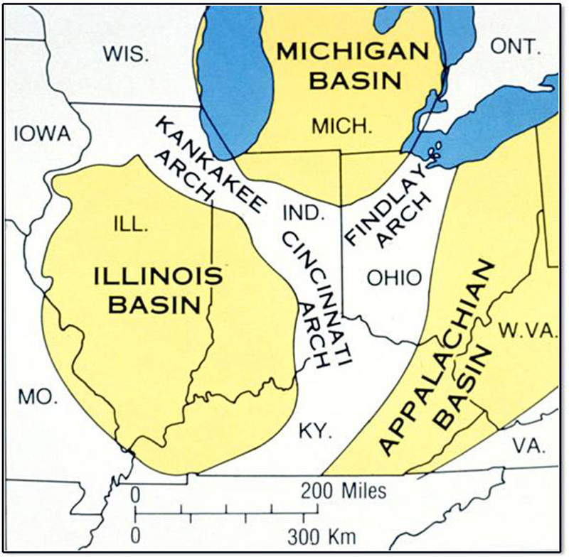
Figure 1.
Map showing regional tectonic features.
Introduction:
The principal bedrock units found in Marion County are composed of
The
Stratigraphic units:
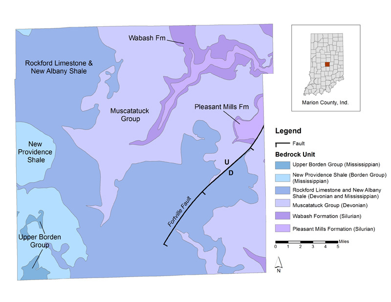
Figure 2.
Map showing the bedrock geology of Marion County (from Indiana Geological Survey, 2010; modified from Hasenmueller, 2003a, b).
Overview
The following rock units were mapped in Marion County by Hasenmueller (2003a, b) and are listed from youngest
to oldest: (1) upper part of the Borden Group (Mississippian) (Edwardsville and Spickert Knob Formations
undifferentiated), (2) New Providence Shale (Mississippian), (3) Rockford Limestone (Mississippian) and New
Albany Shale (
Edwardsville and Spickert Knob Formations undifferentiated (Borden Group) and New Providence Shale (Borden Group)
| System | Group | Formation |
|---|---|---|
| Mississippian | Borden | Edwardsville and Spickert knob Formations |
| New Providence Shale | ||
| Rockford Limestone and New Albany Shale | ||
| Devonian | New Albany Shale | |
| Muscatatuck | North Vernon Limestone | |
| Jeffersonville Limestone | ||
| Silurian | Salina | Wabash Formation |
| Pleasant Mills Formation |
Figure 3.
Mapped column showing the relationships of Paleozoic rock-units in Marion County.
The youngest unit at the bedrock surface in Marion County is the Borden Group of Mississippian age (fig. 3). The stratigraphic unit is chiefly greenish-gray shale and siltstone and fine-grained sandstone (Rexroad, 1986a; Indiana Geologic Names Information System, 2013). The Borden Group forms the bedrock surface in the southwestern part of Marion County (Fleming, Brown, and Ferguson, 2000; Hasenmueller, 2003a); however, a complete section of the Borden is not present within the county. As much as 250 to 300 ft (76.2 to 91.4 m) of the unit is present below some elevated parts of the bedrock surface (Fleming, Brown, and Ferguson, 2000).
The upper part of the Borden Group is composed of the Edwardsville and Spickert Knob Formations, which consist
of siltstone, shale, and fine-grained sandstone with minor amounts of limestones (Hasenmueller, 2003a, b). In
Marion County, the two formations are difficult to differentiate and are mapped as a single interval. The
thickness of the upper part of the Borden ranges from zero feet at its erosional edge to a maximum eroded
thickness of 98 ft (29.9 m). The sandstone bodies in the upper portions of the unit form locally productive
aquifers (Fleming, Brown, and Ferguson, 2000).
The lower part of the Borden is composed of the New Providence Shale, a greenish-gray to dark-gray shale
that borders on
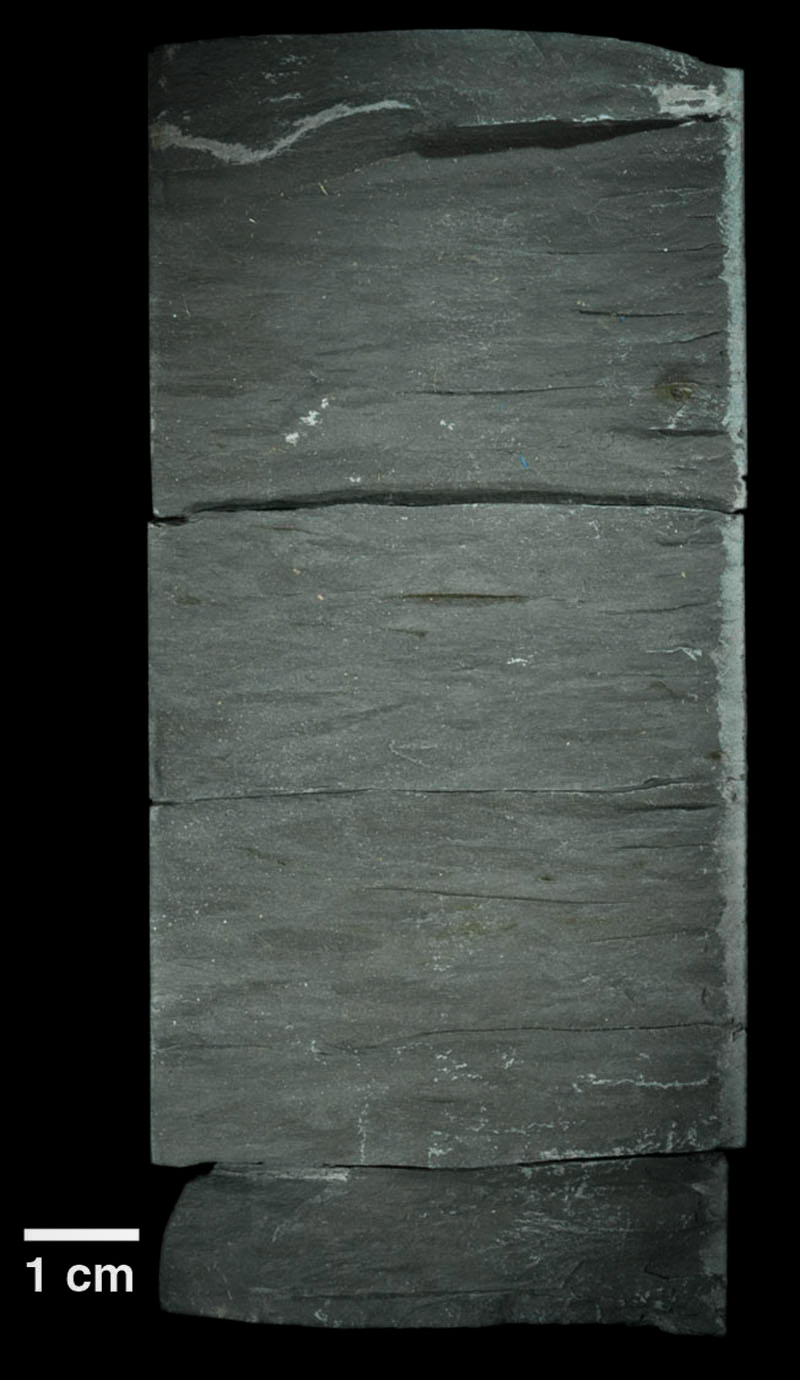
Figure 4.
A core of the New Providence Shale (Mississippian) from Indiana Geological Survey drill hole 273. The drill
hole was located on Indianapolis International Airport property in SE1/4 SE1/4 sec. 27, T. 15 N., R. 2 E.
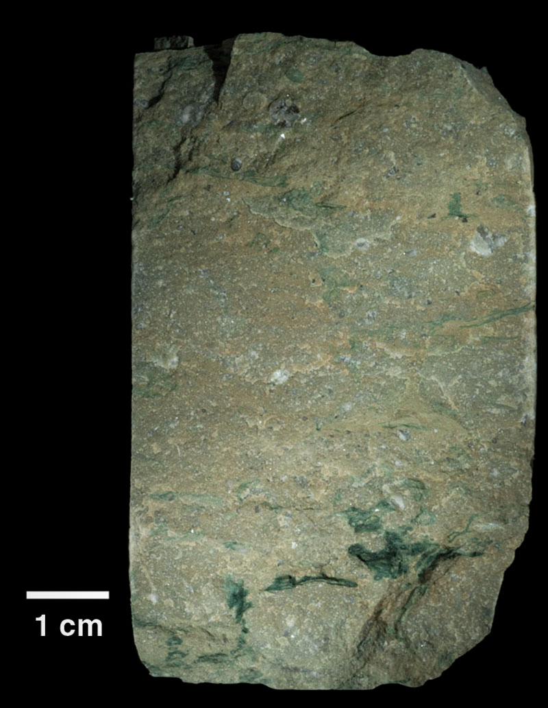
Figure 5.
A core of the Rockford Limestone (Mississippian) from Indiana Geological Survey drill hole 273.
The drill hole was located on Indianapolis International Airport property in SE1/4 SE1/4 sec. 27, T. 15 N., R. 2 E.
Note the characteristic green mottling of the limestone.

Figure 6.
A core of the brownish-black and greenish-gray shale of the New Albany Shale (Devonian and Mississippian)
from Indiana Geological Survey drill hole 273. The drill hole was located on Indianapolis International Airport
property in SE1/4 SE1/4 sec. 27, T. 15 N., R. 2 E.
Rockford Limestone and New Albany Shale undifferentiated
The Rockford Limestone of Mississippian age underlies the Borden Group. In a bedrock core from Marion County,
the Rockford Limestone is a light gray to light brownish-gray limestone and is about 7 ft (2.1 m) in thickness.
It is
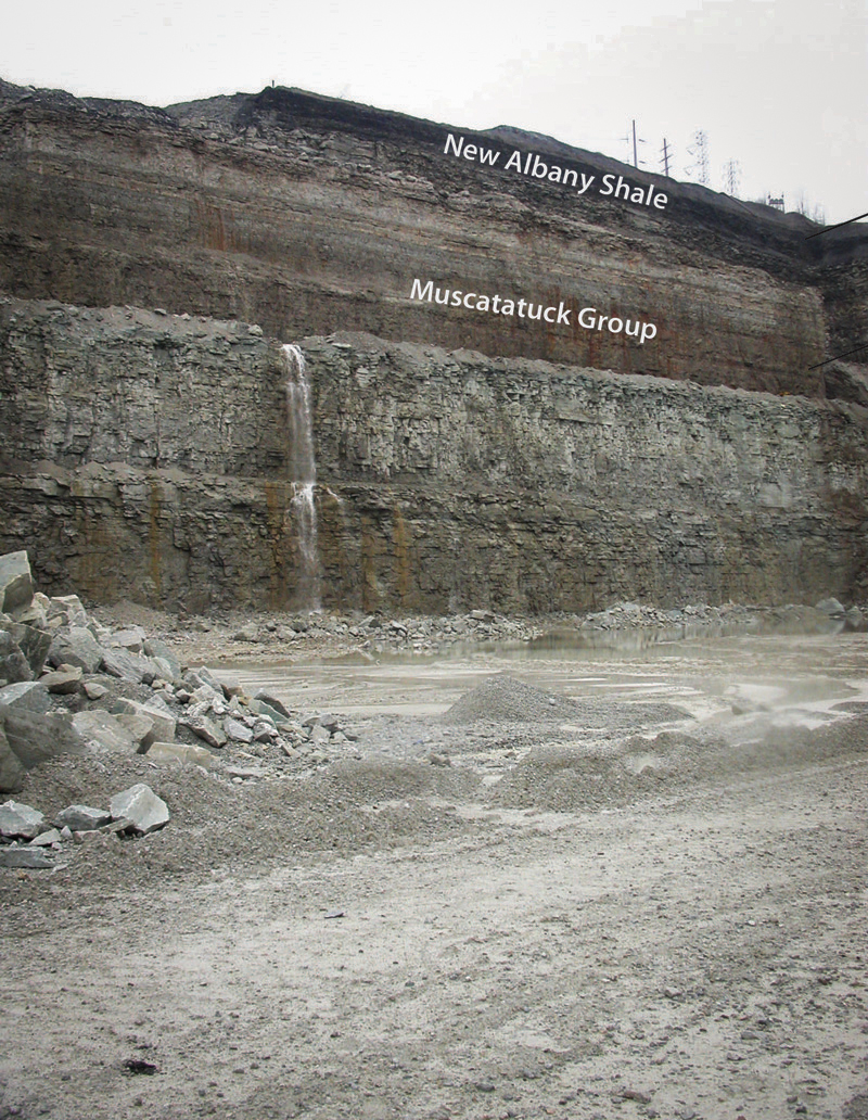
Figure 7.
The brownish-black shale of the New Albany Shale and the gray to brownish-gray limestone and dolomite of
the Muscatatuck Group at a quarry in Indianapolis.
Because the Rockford Limestone is rarely more than 10 ft (3.0 m) thick, it was too thin to map as a separate unit
and was mapped with the New Albany Shale in Marion County (Hasenmueller, 2003a, b). The New Albany Shale of Devonian
and Mississippian age underlies the Rockford Limestone and overlies the Devonian carbonate rocks. It consists of
brownish-black carbon-rich shale, greenish-gray shale, and minor amounts of dolostone and dolomitic quartz sandstone
(Lineback, 1968, 1970; Hasenmueller, 1986; Indiana Geologic Names Information System
(https://igs.indiana.edu/IGNIS/) (fig. 6). The unit is typically between 110 and 130 ft
(33.5 and 39.6 m) thick in the Marion County area (Hasenmueller and Bassett, 1979) and is poorly
There are no natural outcroppings of the New Albany Shale in Marion County; however, the lower 40 ft (12.2 m) of the
formation are exposed in the Harding Street Quarry near the junction of Interstate 465 and State Road 37 on the south
side of Indianapolis. Here, the shale is removed as overburden in the quarrying of the underlying Devonian
Muscatatuck Group
The Devonian Muscatatuck Group is composed of two formations, the North Vernon Limestone and the Jeffersonville Limestone.
The North Vernon Limestone is medium light gray to yellowish-gray, fine- to medium-grained, slightly shaly limestone
(Becker, 1974). In central Indiana, the Jeffersonville is composed of light to medium gray to brownish-gray, fine-grained
dolostone and limestone in the upper part and pale brown, finely to medium crystalline dolostone in the lower part (Droste
and Shaver, 1975). Scattered, frosted, and well-rounded
Wabash Formation
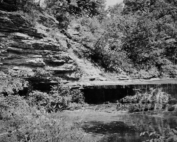
Figure 8.
Type section of the Liston Creek Limestone Member of the Wabash Formation (Silurian) on Liston Creek, southwestern Wabash County, Indiana.
The Liston Creek overlies the Red Bridge Limestone Bed (rim of falls), which in turn overlies the Mississinewa Shale Member of the Wabash
Formation. This section is now under water in the Mississinewa Reservoir. Photograph from Shaver (1961).
The Wabash Formation is composed of two members, these are, in descending order, the Liston Creek Limestone and Mississinewa
Shale Members. At its type section in Wabash County, Indiana, the Liston Creek is a limestone and dolomitic limestone that is
light gray and tan, fine- to medium-grained, and contains
The contact of the Wabash Formation with the overlying Muscatatuck Group is a regional
Pleasant Mills Formation
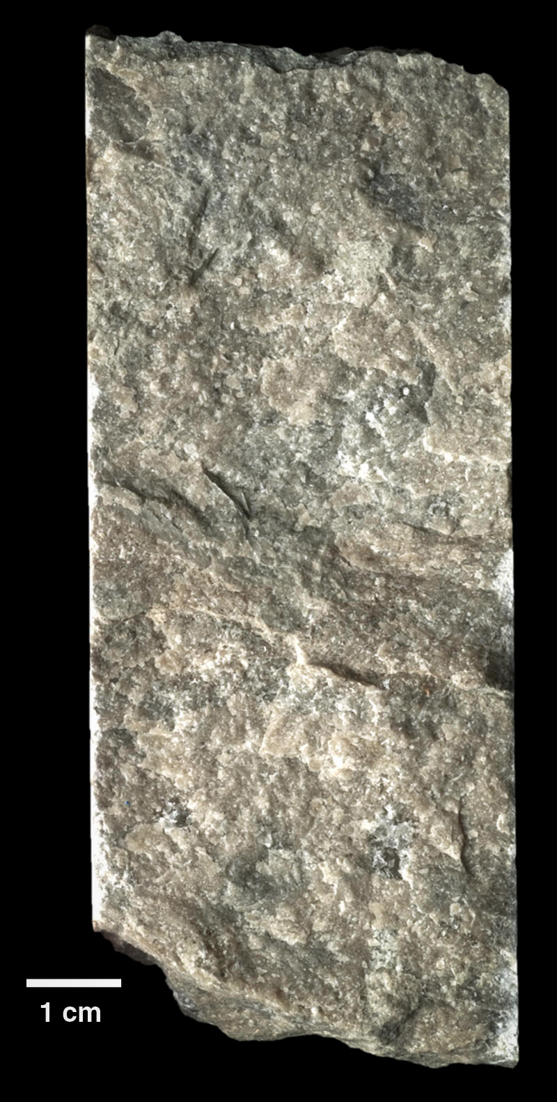
Figure 9.
A core of the Louisville Member of the Pleasant Mills Formation (Silurian) from the Mobile Drilling Company No. 1 Fee drill
hole. The drill hole was located in SE1/4 SE1/4 sec. 25, T. 15 N., R. 3 E. in Marion County.
The Pleasant Mills Formation is composed of dolostone, limestone, and
References
Becker, L. E., 1974, Silurian and Devonian rocks in Indiana southwest of the Cincinnati Arch: Indiana Geological Survey Bulletin 50, 83 p.
Droste, J. B., and Shaver, R. H., 1975, The Jeffersonville Limestone (Middle Devonian) of Indiana-stratigraphy, sedimentation, and relation to Silurian reef-bearing rocks: American Association of Petroleum Geologists Bulletin, v. 59, p. 393-412.
Droste, J. B., and Shaver, R. H., 1982, The Salina Group (Middle and Upper Silurian) of Indiana: Indiana Geological Survey Special Report 24, 41 p.
Droste, J. B., and Shaver, R. H., 1986a, Liston Creek Limestone Member, in Shaver, R. H., Ault, C. H., Burger, A. M., Carr, D. D., Droste, J. B., Eggert, D. L., Gray, H. H., Harper, Denver, Hasenmueller, N. R., Hasenmueller, W. A., Horowitz, A. S., Hutchison, H. C., Keith, B. D., Keller, S. J., Patton, J. B., Rexroad, C. B., and Wier, C. E., Compendium of Paleozoic rock-unit stratigraphy in Indiana-a revision: Indiana Geological Survey Bulletin 59, p. 81-82.
Droste, J. B., and Shaver, R. H., 1986b, Pleasant Mills Formation, in Shaver, R. H., Ault, C. H., Burger, A. M., Carr, D. D., Droste, J. B., Eggert, D. L., Gray, H. H., Harper, Denver, Hasenmueller, N. R., Hasenmueller, W. A., Horowitz, A. S., Hutchison, H. C., Keith, B. D., Keller, S. J., Patton, J. B., Rexroad, C. B., and Wier, C. E., Compendium of Paleozoic rock-unit stratigraphy in Indiana-a revision: Indiana Geological Survey Bulletin 59, p. 114-116.
Fleming, A. H., Brown, S. E., and Ferguson, V. R., 2000, Geologic and hydrogeologic framework, in Brown, S. E., and Laudick, A. J., eds., 2003, Hydrogeologic framework of Marion County, Indiana-a digital atlas illustrating hydrogeologic terrain and sequence: Indiana Geological Survey Open-File Study 00-14, CD-ROM.
Gray, H. H., Ault, C. H., and Keller, S. J., 1987, Bedrock geologic map of Indiana: Indiana Geological Survey Miscellaneous Map 48, scale 1:500,000.
Hartke, E. J., Ault, C. H., Austin, G. S., Becker, L. E., Bleuer, N. K., Herring, W. C., and Moore, M. C., 1980, Geology for environmental planning in Marion County, Indiana: Indiana Geological Survey Special Report 19, 53 p.
Hasenmueller, N. R., 1986, New Albany Shale, in Shaver, R. H., Ault, C. H., Burger, A. M., Carr, D. D., Droste, J. B., Eggert, D. L., Gray, H. H., Harper, Denver, Hasenmueller, N. R., Hasenmueller, W. A., Horowitz, A. S., Hutchison, H. C., Keith, B. D., Keller, S. J., Patton, J. B., Rexroad, C. B., and Wier, C. E., Compendium of Paleozoic rock-unit stratigraphy in Indiana-a revision: Indiana Geological Survey Bulletin 59, p. 100-102.
Hasenmueller, N. R., and Bassett, J. L., 1979, Map of Indiana showing thickness of the New Albany Shale (Devonian and Mississippian) and equivalent strata: Morgantown Energy Technology Center, U.S. Department of Energy, EGSP Series No. 805, scale 1:500,000.
Hasenmueller, W. A., 2003a, Bedrock geologic map of the Indianapolis 30 x 60 minute quadrangle, central Indiana: Indiana Geological Survey Open-File Study 03-07, scale 1:100,000.
Hasenmueller, W. A., 2003b, Bedrock geologic map of the west half of the New Castle 30 x 60 minute quadrangle, central Indiana: Indiana Geological Survey Open-File Study 03-10, scale 1:100,000.
Hasenmueller, W. A., and James, C. L., 2002, Map showing structure on top of the Trenton Limestone in the Indiana Heartland: Indiana Geological Survey Open-File Study 02-06, scale 1:250,000.
Indiana Geological Survey, 2010, Marion County-a geologic atlas: Indiana Geological Survey Web page, http://marioncounty.igs.indiana.edu/index.html, date accessed, Nov. 23, 2010.
Indiana Geological Survey Geologic Names Committee, 2009, Indiana Geologic Names Information System: Indiana Geological Survey website, https://igs.indiana.edu/geology/geologicNames/ date accessed Nov. 5, 2013.
Lineback, J. A., 1968, Subdivisions and depositional environments of New Albany Shale (Devonian-Mississippian) in Indiana: American Association of Petroleum Geologists Bulletin, v. 52, p. 1,291-1,303.
Lineback, J. A., 1970, Stratigraphy of the New Albany Shale in Indiana: Indiana Geological Survey Bulletin 44, 73 p.
Rexroad, C. B., 1986a, Borden Group, in Shaver, R. H., Ault, C. H., Burger, A. M., Carr, D. D., Droste, J. B., Eggert, D. L., Gray, H. H., Harper, Denver, Hasenmueller, N. R., Hasenmueller, W. A., Horowitz, A. S., Hutchison, H. C., Keith, B. D., Keller, S. J., Patton, J. B., Rexroad, C. B., and Wier, C. E., Compendium of Paleozoic rock-unit stratigraphy in Indiana-a revision: Indiana Geological Survey Bulletin 59, p. 17-18.
Rexroad, C. B., 1986b, New Providence Shale, in Shaver, R. H., Ault, C. H., Burger, A. M., Carr, D. D., Droste, J. B., Eggert, D. L., Gray, H. H., Harper, Denver, Hasenmueller, N. R., Hasenmueller, W. A., Horowitz, A. S., Hutchison, H. C., Keith, B. D., Keller, S. J., Patton, J. B., Rexroad, C. B., and Wier, C. E., Compendium of Paleozoic rock-unit stratigraphy in Indiana-a revision: Indiana Geological Survey Bulletin 59, p. 102-103.
Rupp, J. A., 1997 [copyright date], Tectonic features of Indiana: Indiana Geological Survey Web page, https://igs.indiana.edu/Bedrock/tectonic.cfm, date accessed, March 21, 2007.
Shaver, R. H., with contributions by Gray, H. H., Pinsak, A. P., Sunderman, J. A., Thornbury, W. D., and Wayne, W. J., 1961, Stratigraphy of the Silurian rocks of northern Indiana: Indiana Geological Survey Field Conference Guidebook 10, 62 p.