

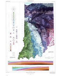
This large-format color map depicts the bedrock geology of Indiana; it also shows known faults and indicates unconsolidated material thickness (on top of bedrock). The southern limit of Wisconsinan and older glacial deposits as well as two cross sections are also shown.
Scale, 1:500,000;
Size: 32" x 46"
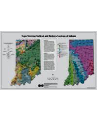
Pair this map with the Quaternary Geologic Map of Indiana (MM49) to see the full picture of Indiana geology.
Gray, H. H., Ault, C. H., and Keller, S. J., 1987, Bedrock geologic map of Indiana: Indiana Geological Survey Miscellaneous Map 48, scale 1:500,000.
You may also like:


Keywords: teachers, geologic map, bedrock, wall map
Can't find what you're looking for? Feel free to contact us directly:
Indiana Geological and Water Survey
1001 E. 10th St.
Bloomington, IN 47405
812-855-7636 (phone)
812-855-2862 (fax)
IGWSinfo@indiana.edu
IGS Return Policy
- Original sales receipt required.
- Returns accepted within 30 days of purchase date.
- Refund will be issued by the same method of payment as purchased.
- Products must be returned in the same new condition as purchased.
- Refunds on custom orders and digital products are NOT allowed.
- Customers are responsible for paying shipping costs to return products.
Updated 8/19/2020
