

This large-format color map depicts the surficial geologic materials deposited during Quaternary time. The map classifies deposits as being from Holocene, Wisconsinan to Holocene, or Pre-Wisconsinan age. Areas with little or no Quaternary deposits are also shown.
Scale: 1:500,000;
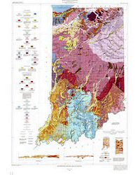
Size: 31" x 43". Pair this map with the Bedrock Geologic Map of Indiana (MM48) to see the full picture of Indiana geology.
Gray, H. H., 1989, Quaternary geologic map of Indiana: Indiana Geological Survey Miscellaneous Map 49, scale 1:500,000.
You may also like:

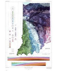
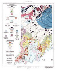
Keywords: teachers, geologic map, Quaternary, wall map
Can't find what you're looking for? Feel free to contact us directly:
Indiana Geological and Water Survey
1001 E. 10th St.
Bloomington, IN 47405
812-855-7636 (phone)
812-855-2862 (fax)
IGWSinfo@indiana.edu
IGS Return Policy
- Original sales receipt required.
- Returns accepted within 30 days of purchase date.
- Refund will be issued by the same method of payment as purchased.
- Products must be returned in the same new condition as purchased.
- Refunds on custom orders and digital products are NOT allowed.
- Customers are responsible for paying shipping costs to return products.
Updated 8/19/2020
