
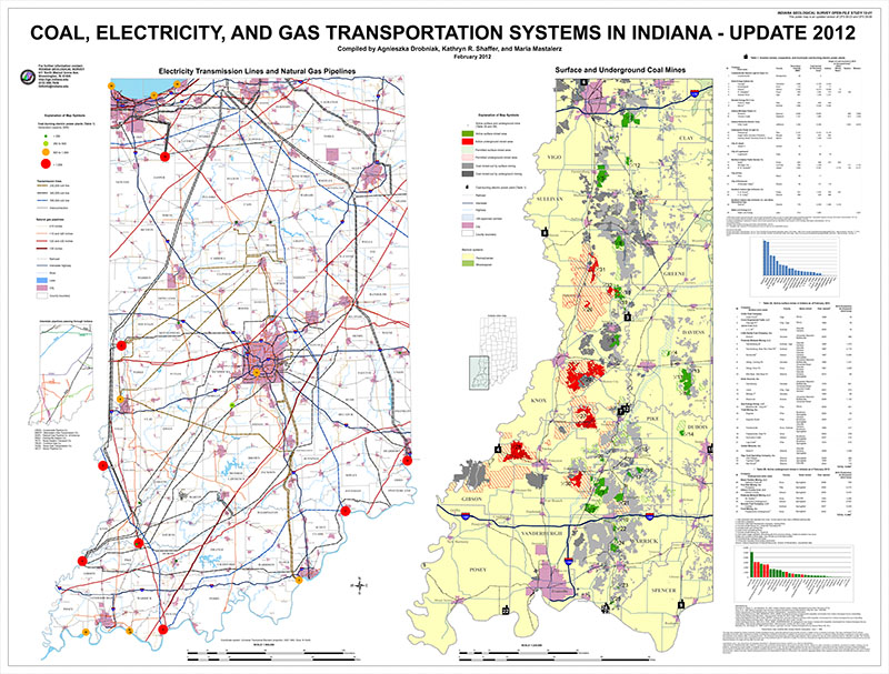
Two maps are featured on this poster. One map shows the locations of transmission lines and natural gas pipelines in Indiana, including their capacities, as well as showing coal-burning electric power plants and their capacity ranges. The second map shows surface and underground coal mines, both active and abandoned, as well as areas permitted for mining, on a basemap of the bedrock systems in Indiana. Accompanying tables list active coal mines and existing power plants. This map is the updated version of IGS Open-File Studies 06-03 (2006) and 09-06 (2009).
Drobniak, A. , Shaffer, K. R., Mastalerz, M. 2012, Coal, electricity, and gas transportation systems in Indiana - update 2012: Indiana Geological Survey Open-File Study 12-01
Notes: Map scales: 1:500,000 and 1:325,000
You may also like:


Keywords: coal, coal mine, electricity, fuel, gas, mines, pipelines, power, power plant, transmission, wall map
Can't find what you're looking for? Feel free to contact us directly:
Indiana Geological and Water Survey
1001 E. 10th St.
Bloomington, IN 47405
812-855-7636 (phone)
812-855-2862 (fax)
IGWSinfo@indiana.edu
IGS Return Policy
- Original sales receipt required.
- Returns accepted within 30 days of purchase date.
- Refund will be issued by the same method of payment as purchased.
- Products must be returned in the same new condition as purchased.
- Refunds on custom orders and digital products are NOT allowed.
- Customers are responsible for paying shipping costs to return products.
Updated 8/19/2020
