

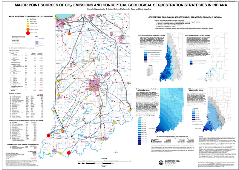
Five maps are presented in a poster format to show an overall picture of the status of CO2 emissions in Indiana, including point sources of CO2, electrical transmission lines, and possible geologic sequestration strategies. Potential geologic sequestration strategies include adsorption within coal seams that are too deep or too inferior in quality to mine, CO2 isolation in mature or depleted oil and natural gas reservoirs, CO2 storage in deep, saline-water-filled formations and CO2 adsorption in organic-rich shales. In addition, the poster contains tabular data about CO2 emissions. This publication was updated in 2009 in IGS Open-File Study 09-09.
Drobniak, A. , Shaffer, K. R., Rupp, J. A., Mastalerz, M. 2007, Major point sources of CO2 emissions and conceptual geological sequestration strategies in Indiana: Indiana Geological Survey Open-File Study 07-01
You may also like:

Keywords: electric power, coal, carbon dioxide, carbon, emissions, sequestration, natural gas, CO2, electricity, electric power plants, industry, industrial plants, energy, map, wall map
Can't find what you're looking for? Feel free to contact us directly:
Indiana Geological and Water Survey
1001 E. 10th St.
Bloomington, IN 47405
812-855-7636 (phone)
812-855-2862 (fax)
IGWSinfo@indiana.edu
IGS Return Policy
- Original sales receipt required.
- Returns accepted within 30 days of purchase date.
- Refund will be issued by the same method of payment as purchased.
- Products must be returned in the same new condition as purchased.
- Refunds on custom orders and digital products are NOT allowed.
- Customers are responsible for paying shipping costs to return products.
Updated 8/19/2020