
Age:Silurian Type designation:Type area: The Moccasin Springs Formation was named by Lowenstam (1949, p. 16) for exposures of multicolored silty argillaceous limestones and shales that overlie the St. Clair Limestone in the Silurian outcrop area on either side of the Mississippi River in Cape Girardeau and Ste. Genevieve Counties, Missouri, and in Alexander and Union Counties, Illinois (Droste and Shaver, 1986). History of usage:Original definition: In his original description, Lowenstam (1949) noted that the Mocassin Springs was "all the Niagaran strata overlying the St. Clair formation" in the area. At that time the stratigraphically overlying Bailey Limestone, whose type area is one county north of Cape Girardeau County, was considered to be Devonian in age, and no Upper Silurian rocks were identified (Droste and Shaver, 1986). Therefore, Lowenstam did not exclude part of what is called the Moccasin Springs here, even though a part of it may be post-Niagaran in age (Droste and Shaver, 1986).
Description:The Moccasin Springs is striking for its coloration in pastel shades of pink, green, yellow, tan, and gray, partly in mottlings, and more intense dark-gray and red to purple colors. It consists mostly of dense to fine-grained somewhat argillaceous limestones that are interbedded as variably colored units (Droste and Shaver, 1986). About the top 20 ft (6 m) of the formation in most places consists of dark-gray to black dolomitic shale interbedded with dark-greenish-gray very fine grained argillaceous limestone (Droste and Shaver, 1986). Dark-red carbonate rocks are particularly characteristic of the lower part of the formation (Droste and Shaver, 1986).
Boundaries:The Moccasin Springs is underlain by the St. Clair Limestone, and the boundary is especially marked by the change between impure carbonate rocks above and pure carbonate rocks below (Droste and Shaver, 1986). It is overlain by the Bailey Limestone, and the contact is placed between darker and impurer carbonate rocks below and lighter and more neutrally colored and purer (except for chert) carbonate rocks above (Droste and Shaver, 1986). Both contacts are believed to be conformable (Droste and Shaver, 1986). Correlations:Because diachroneity in a basin-to-platform sense may apply to both the top and the bottom Moccasin Springs contacts (as suggested by Droste and Shaver, 1980, fig. 4 and p. 569), simple, precise statements of correlation cannot be made. The Moccasin Springs of Indiana extends to units of the same name in southern Illinois and western Kentucky (Droste and Shaver, 1986). In Kentucky areas distal from the Illinois Basin, equivalent rocks include the Dixon Limestone and the Brownsport Formation (Droste and Shaver, 1986). In southwestern Indiana, lowest Moccasin Springs and highest St. Clair rocks may have some age equivalency, and northeastward partly or wholly age-equivalent rocks may include the Louisville Limestone and certainly the Mississinewa Shale Member of the Wabash Formation (Droste and Shaver, 1986). Middle Racine rocks of northern Illinois are also correlative (Droste and Shaver, 1986).
|
|
Regional Indiana usage:
Illinois Basin (COSUNA 11)
Misc/Abandoned Names:None Geologic Map Unit Designation:Sms Note: Hansen (1991, p. 52) in Suggestions to authors of the reports of the United States Geological Survey noted that letter symbols for map units are considered to be unique to each geologic map and that adjacent maps do not necessarily need to use the same symbols for the same map unit. Therefore, map unit abbreviations in the Indiana Geologic Names Information System should be regarded simply as recommendations. |
COSUNA areas and regional terminologyNames for geologic units vary across Indiana. The Midwestern Basin and Arches Region COSUNA chart (Shaver, 1984) was developed to strategically document such variations in terminology. The geologic map (below left) is derived from this chart and provides an index to the five defined COSUNA regions in Indiana. The regions are generally based on regional bedrock outcrop patterns and major structural features in Indiana. (Click the maps below to view more detailed maps of COSUNA regions and major structural features in Indiana.) 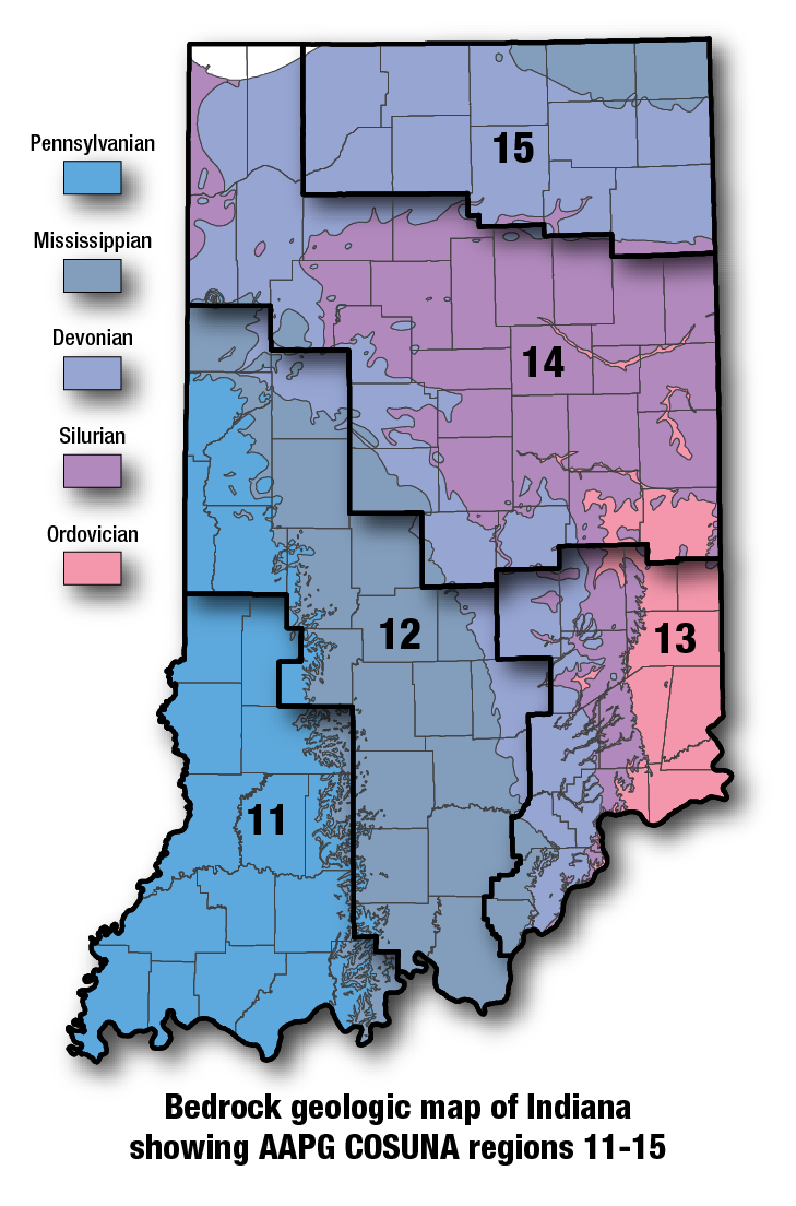
COSUNA areas and numbers that approximate regional bedrock outcrop patterns and major structural features in Indiana. 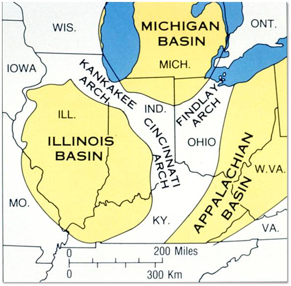
Major tectonic features that affect bedrock geology in Indiana. |
See also:References:Droste, J. B., and Shaver, R. H., 1980, Recognition of buried Silurian reefs in southwestern Indiana: Journal of Geology, v. 88, p. 567–587. Hansen, W. R., 1991, Suggestions to authors of the reports of the United States Geological Survey (7th ed.): Washington, D.C., U.S. Geological Survey, 289 p. Lowenstam, H. A., 1949, Niagaran reefs in Illinois and their relation to oil accumulation: Illinois State Geological Survey Report of Investigations 145, 36 p. Shaver, R. H., coordinator, 1984, Midwestern basin and arches region–correlation of stratigraphic units in North America (COSUNA): American Association of Petroleum Geologists Correlation Chart Series. |
|
For additional information, contact:
Nancy Hasenmueller (hasenmue@indiana.edu)Date last revised: April 5, 2017
