The upper part of the Well Record Page is called the Well Header. The Well Record page is the opening page for the Well Record, which contains data associated with a particular well. The page opens when its associated IGS ID Number has been selected from a Well Record Search.
The Well Header section of the Well Record Page primarily contains information unique to a “single spot on the ground” for any drilled or permitted well. Most of the data fields describe an aspect of the well’s location, although several data fields are used to store summary data about a well to facilitate the sorting of records or for mapping.
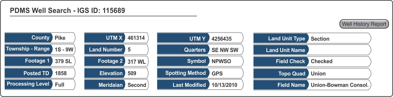
The values displayed in the Well Header are stored in the Location Table. When the PDMS tables are downloaded (see Downloading PDMS Tables), the Location Table is downloaded by default.
Data fields in the Well Header (Location Table)
Follow Links to full explanations:
| ● | County | County Name |
| ● | UTM X | Universal Transverse Mercator X coordinate (west - east) |
| ● | UTM Y | Universal Transverse Mercator Y coordinate (south - north) |
| ● | Land Unit Type | Type of Land Unit |
| ● | Township and Range | |
| ● | Land Number | Official number assigned to identify sections or other land unit types |
| ● | Quarters | Subdivisions of a standard Section of land |
| ● | Land Unit Name | Proper name used to identify some Land Types |
| ● | Footage 1 | First Footage and Direction used to describe a well's location |
| ● | Footage 2 | Second Footage and Direction used to describe a well's location |
| ● | Symbol | Petroleum Well Symbol Code |
| ● | Field Check | Field Check Status of the posting whether a well has, or needs to be, checked in the field |
| ● | Posted TD | The deepest Total Depth of any operation conducted on a well, adjusted for True Vertical Depth |
| ● | Elevation | The ground surface elevation (feet) determined in the field when the well was field-checked |
| ● | Spotting Method | Method by which well location coordinates were determined for wells/locations in the PDMS |
| ● | Field Name | Name of the currently defined petroleum field where the well location falls |
| ● | Processing Level | Indicates the progress that has been made entering data in the PDMS for a particular Well Record |
| ● | Meridian | Designates which of two base lines was used in the Congressional Township and Range Survey System to map two respective areas in Indiana |
| ● | Last Modified | Most recent date when any modification was made to a Well Record |
| ● | Topo Quad | Name of the USGS (U.S. Geological Survey) 7-1/2 minute topographic quadrangle within which a well location falls |