

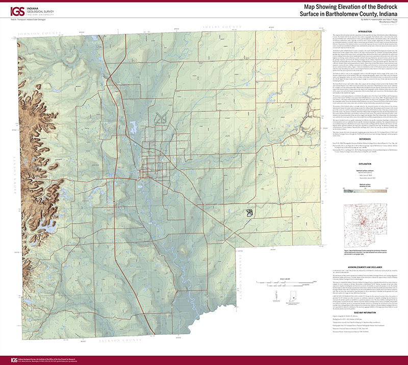
The computer-derived contours and color ramp shown on this map show the shape of the bedrock surface in Bartholomew County. The shaded relief on the map shows the modern topography. The bedrock surface is the surface that marks the top of lithified rock. In Bartholomew County, and throughout Indiana, the bedrock surface is the erosional top of Paleozoic sedimentary rocks. Typically covered by soils or much younger (Quaternary or Tertiary) deposits of unconsolidated sediment, it is locally visible at natural outcrops of bedrock or in man-made excavations that penetrate bedrock. The position of the bedrock surface is economically important because it marks the abrupt transition from easily excavated unconsolidated sediments into solid bedrock and because it limits the lateral and vertical extent of economically important bedrock units.
Hasenmueller, W. A., and Rupp, R. F., 2017, Map showing elevation of the bedrock surface in Bartholomew County, Indiana: Indiana Geological Survey Miscellaneous Map 97, scale 1:48,000.
You may also like:

Keywords: map, bedrock surface, Bartholomew County
Can't find what you're looking for? Feel free to contact us directly:
Indiana Geological and Water Survey
1001 E. 10th St.
Bloomington, IN 47405
812-855-7636 (phone)
812-855-2862 (fax)
IGWSinfo@indiana.edu
IGS Return Policy
- Original sales receipt required.
- Returns accepted within 30 days of purchase date.
- Refund will be issued by the same method of payment as purchased.
- Products must be returned in the same new condition as purchased.
- Refunds on custom orders and digital products are NOT allowed.
- Customers are responsible for paying shipping costs to return products.
Updated 8/19/2020