

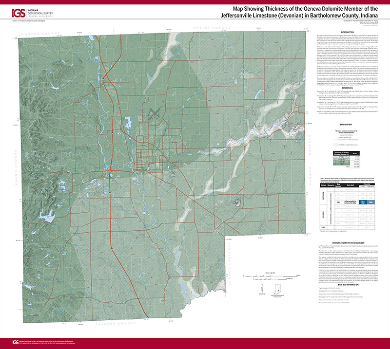
The computer-derived contours and color ramp on this map show the thickness of the Geneva Dolomite Member of the Jeffersonville Limestone (Devonian) in Bartholomew County. The shaded relief on the map shows the modern topography. The Geneva is a significant bedrock aquifer in Bartholomew County that is the source of groundwater in many existing water wells and has the potential to be a significant source of groundwater in the future. The thickness of the Geneva shown on this map in conjunction with the depth to the top of the Geneva shown on Hasenmueller and Rupp’s (2017b) map are technical resources for protecting and developing this aquifer.
Hasenmueller, W. A., and Rupp, R. F., 2017, Map showing thickness of the Geneva Dolomite Member of the Jeffersonville Limestone (Devonian) in Bartholomew County, Indiana: Indiana Geological Survey Miscellaneous Map 103, scale 1:48,000.
You may also like:

Keywords: map, thickness, Geneva Dolomite, Jeffersonville Limestone, Bartholomew County
Can't find what you're looking for? Feel free to contact us directly:
Indiana Geological and Water Survey
1001 E. 10th St.
Bloomington, IN 47405
812-855-7636 (phone)
812-855-2862 (fax)
IGWSinfo@indiana.edu
IGS Return Policy
- Original sales receipt required.
- Returns accepted within 30 days of purchase date.
- Refund will be issued by the same method of payment as purchased.
- Products must be returned in the same new condition as purchased.
- Refunds on custom orders and digital products are NOT allowed.
- Customers are responsible for paying shipping costs to return products.
Updated 8/19/2020