

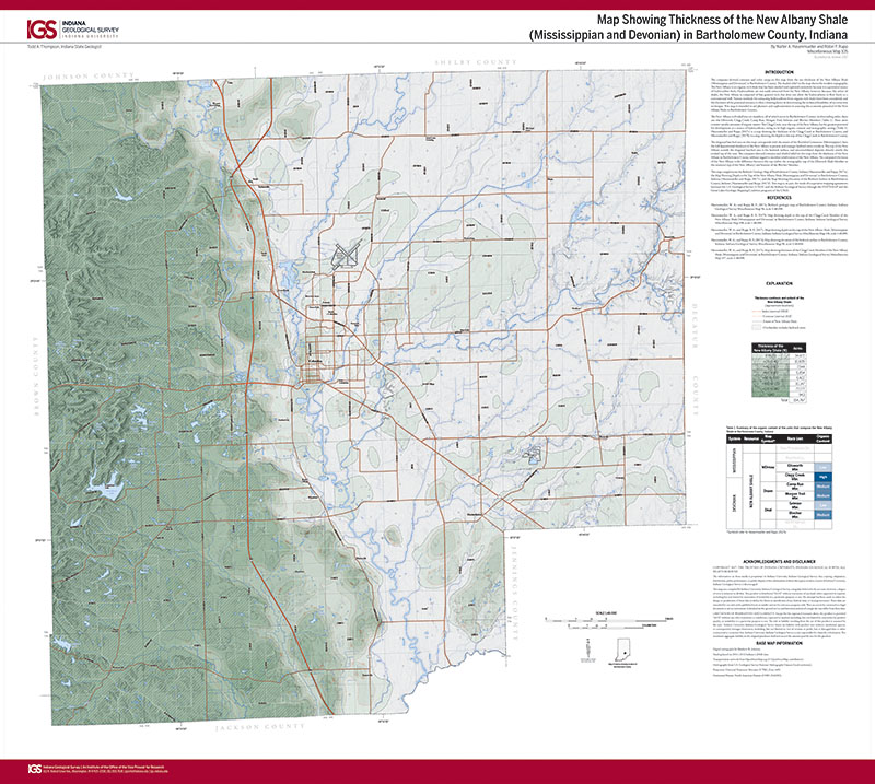
The computer-derived contours and color ramp on this map show the net thickness of the New Albany Shale (Mississippian and Devonian) in Bartholomew County. The shaded relief on the map shows the modern topography. The New Albany is an organic-rich shale that has been studied and explored extensively because it is a potential source of hydrocarbon fuels. Hydrocarbons are not easily extracted from the New Albany, however, because, like other oil shales, the New Albany is composed of fine-grained rock that does not allow the hydrocarbons to flow freely to a conventional well. Various methods for extracting hydrocarbons from organic-rich shales have been considered, and the thickness of the potential resource is often a limiting factor in determining the technical feasibility of an extraction technique. This map is intended to aid planners and explorationists in assessing the economic potential of the New Albany Shale in Bartholomew County.
Hasenmueller, W. A., and Rupp, R. F., 2017, Map showing thickness of the New Albany Shale (Mississippian and Devonian) in Bartholomew County, Indiana: Indiana Geological Survey Miscellaneous Map 105, scale 1:48,000.
You may also like:

Keywords: map, New Albany Shale, thickness, economic, Bartholomew County, hydrocarbon
Can't find what you're looking for? Feel free to contact us directly:
Indiana Geological and Water Survey
1001 E. 10th St.
Bloomington, IN 47405
812-855-7636 (phone)
812-855-2862 (fax)
IGWSinfo@indiana.edu
IGS Return Policy
- Original sales receipt required.
- Returns accepted within 30 days of purchase date.
- Refund will be issued by the same method of payment as purchased.
- Products must be returned in the same new condition as purchased.
- Refunds on custom orders and digital products are NOT allowed.
- Customers are responsible for paying shipping costs to return products.
Updated 8/19/2020