

Valmeyeran Series
Mississippian System
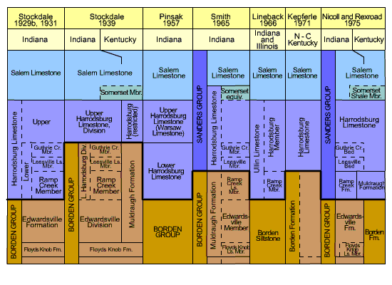
Type locality and history of nomenclature: The Sanders Group was named by Smith (1965) to include the Harrodsburg and Salem Limestones. The group was expanded by Nicoll and Rexroad (1975, pl. 2, p. 4), who raised the Ramp Creek Limestone Member (Muldraugh Formation) to formational rank and included it and the laterally equivalent Muldraugh Formation in the Sanders Group. (See under "Harrodsburg Limestone" a chart [fig. 1] summarizing the history of nomenclature of the Sanders Group and its subdivisions.) The type locality is near Sanders in Monroe County, Ind., but a specific type section was not designated. Smith's (1965, p. 9) reference sections are in tributaries of Ramp Creek within half a mile (0.8 km) east and northeast of Sanders and in an abandoned quarry in the center of the E2NW¼SE¼ sec. 33, T. 8 N., R. 1 W. (See the discussion under "Ramp Creek Formation" for excellent nearby reference sections showing the interval from the base of the group up into the Salem Limestone.)
Description: The Sanders Group consists of a variety of carbonate rocks in complex facies relationships. The Ramp Creek and Muldraugh Formations at the base of the group are dominantly a mixture of fine-grained dolomite and of limestone that in places contains abundant echinodermal and bryozoan fragments. Cherty and siliceous intervals are common, and minor amounts of siltstone and shale are present. Above that interval in the Harrodsburg Limestone well-cemented bioclastic calcarenites and calcirudites are dominant over argillaceous limestone, dolosiltites, and shale. The abundance of geodes and chert decreases upward in the group. The Salem Limestone except for the Somerset Shale Member at its base is dominated by porous calcarenite, although it contains a wide variety of other kinds of limestone.
The group crops out along the margin of the Illinois Basin in an irregular arc from Fountain County to southern Harrison County. It is present throughout the subsurface west and south of the outcrop belt. Along the central and southern parts of the belt the Sanders generally ranges between 120 and 150 feet (37 and 46 m) in thickness, but it is thinner toward the north. It thickens abruptly off the margin of the Borden delta deposits (see "Borden Group"), principally because of thickening of the Muldraugh Formation within the resulting topographic basin, and it reaches a maximum thickness of about 510 feet (150 m) in the subsurface in Posey County.
The Sanders Group overlies rocks of the Borden Group with a depositional hiatus marked by a sharp lithologic break and in most places by a zone of glauconite at the top of the Borden. Throughout most of its extent it is overlain conformably by the St. Louis Limestone, although local hiatuses are possible. Along its northern margin, however, the group is truncated by pre-Pennsylvanian erosion and is unconformably overlain by the Mansfield Formation (Morrowan).
Correlation: The Sanders Group is middle Valmeyeran in age. The names Ramp Creek, Harrodsburg, and Salem are used in Illinois, although the first two are considered to be members of the Ullin Formation and "Muldraugh" is considered to be a junior synonym of "Ramp Creek." The units are not precisely isochronous throughout, however. In the Kentucky part of the Illinois Basin the name Salem is also used, but the Warsaw Limestone of Kentucky use approximates the Harrodsburg and all but the lower part of the Ramp Creek-Muldraugh section in Indiana. The latter two formations are equivalent to the Fort Payne Formation in adjacent Illinois and Kentucky. The oldest part of the Sanders Group is in the Gnathodus texanus-Taphrognathus Assemblage Zone (conodonts), and the rest is in the Taphrognathus varians-Apatognathus Assemblage Zone (Nicoll and Rexroad, 1975, p. 2, 3).