

Mississippian System
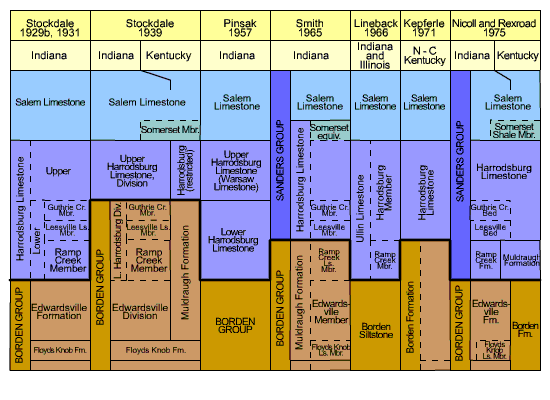
Type section and history of name: The Muldraugh Formation was named by Stockdale (1939, p. 72, 200-201) for a sequence of argillaceous cherty carbonate rocks exposed along a secondary road that crosses the Muldraugh Escarpment south of Phillipsburg, Marion County, Ky. The Muldraugh Formation and the Ramp Creek Formation (which see) are laterally equivalent parts of a single depositional unit lying between the clastic sediments of the Borden Group below and the Harrodsburg Limestone above, but in Indiana and Kentucky the name Muldraugh was limited to the thick carbonate sequence south and west of the Borden delta front (see "Borden Group") by Nicoll and Rexroad (1975). Figure 1 under "Harrodsburg Limestone" summarizes usage, including introduction of the term Muldraugh Formation to Indiana by Smith (1965), where it was assigned three members, the Edwardsville Member and the Ramp Creek Limestone and Floyds Knob Limestone Members.
Description: The Muldraugh Formation is characterized by local and regional variability in thickness and lithology and ranges from about 40 feet (12 m) to more than 400 feet (122 m) in thickness. The major lithologies are limestone, very fine grained dolomite, and silty dolomite, and there are also lesser amounts of shale and siltstone and mixtures of the two. The limestone and the silty dolomite in places contain abundant crinoid and bryozoan fragments. Cherty and siliceous intervals are common, and geodes are abundant in the shale and silty dolomite facies. In Indiana the Muldraugh Formation is exposed only in southernmost Harrison County, but it is in the subsurface southwest of the Borden delta front, which trends roughly northwestward from Harrison County. The formation is separated from the Borden Group (Formation in Kentucky) by a depositional hiatus and is overlain conformably by the Harrodsburg Limestone.
Correlation: Nicoll and Rexroad (1975, p. 16, 17) correlated the uppermost part of the Muldraugh Formation with the lowermost part of the Warsaw Shale of the Mississippi Valley region on the basis of conodonts of the Taphrognathus varians-Apatognathus Assemblage Zone. They found conodonts indicative of the Gnathodus texanus-Taphrognathus Assemblage Zone in the rest and correlated it with the upper part of the Keokuk Limestone of the Mississippi Valley.