

Mississippian System
Type and reference sections and history of name: The Harrodsburg Limestone was named by Hopkins and Siebenthal (1897, p. 296-297) for Harrodsburg in southern Monroe County, Ind. The type section in the NE¼SW¼ sec. 32, T. 7 N., R. 1 W., on the north bluff of Judah Creek is poorly exposed now, and good exposures 1 mile (1.6 km) north of Harrodsburg along former Indiana Highway 37 in the SE¼ sec. 20, T.7 N., R. 1 W., have been used as a reference section. A section exposing the top of the Borden Group, the Harrodsburg Limestone, and the Salem Limestone is less than one-fourth mile (0.4 km) east of that section in the cut on present Indiana Highway 37 in the same quarter section. Another reference section is the cut along the dam-access road at the Monroe Reservoir in the NE¼SE¼ sec. 28, T. 7 N., R. 1 W. (for example, Nicoll and Rexroad, 1975).
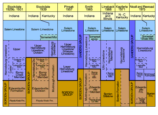
The lower part of the Harrodsburg was divided into the Leesville and Guthrie Creek Members by Stockdale (1939). These units were reduced to the status of beds by Nicoll and Rexroad (1975).
The concept of the Harrodsburg Limestone has undergone numerous modifications since the term was first proposed for rocks between the Borden Group and the Salem Limestone of modern usage. The changes are summarized in Figure 1, and the classification used here is that of Nicoll and Rexroad (1975).
Description: The Harrodsburg Limestone is dominantly a well-cemented bioclastic calcarenite and calcirudite but includes some dolomite, shale, very argillaceous limestone, and minor amounts of chert. In particular an impure unit, which includes geodes and silicified material, is present in some places from 1 to 11 feet (0.3 to 3.4 m) above the base of the formation. Geodes and chert are uncommon elsewhere in the Harrodsburg. Shale is present in places in beds as much as 2 feet (0.6 m) thick. In the upper part of the formation some lenses nearly 20 feet (6 m) thick are almost identical in lithology to common Salem lithologies, although in general they are more firmly cemented. The bioclastic part of the limestone is dominated by crinoid fragments and contains some bryozoans and brachiopods. In the upper part of the Harrodsburg thick beds of fenestrate-bryozoan coquina are present.
The Harrodsburg is present throughout the Indiana part of the Illinois Basin, and its outcropping margin forms an arc extending from Parke County south-southeastward to Harrison County. Northwest of Parke County it is overlapped by Pennsylvanian rocks of the Mansfield Formation. The Harrodsburg is almost 70 feet (21 m) thick in its type area and appears to thin both to the north and the south along its outcrop belt. It thickens somewhat in the subsurface but in most places is no more than 120 feet (37 m) thick above the Borden delta. (See "Borden Group" here and Pinsak, 1957, pl. 1.) Basinward from the paleotopographic margin of the delta, however, the formation is thicker. For example, it is nearly 300 feet (92 m) thick in Vanderburgh County (Lineback, 1966). The northern boundary of the Harrodsburg is obscured by Pennsylvanian overlap where the Mansfield Formation locally overlies it unconformably. Otherwise, the Harrodsburg is overlain conformably and gradationally by the Salem Limestone, and it conformably overlies the Ramp Creek Formation.
Correlation: Conodonts show that the Harrodsburg is the age equivalent of the upper three-fourths of the Warsaw Shale and the lower part of the Salem Limestone of the Mississippi Valley sequence (Nicoll and Rexroad, 1975, p. 16). The Harrodsburg is also considered to be partly equivalent to the Warsaw Limestone of Kentucky (Shaver and others, 1985), a name that had often been applied directly in Indiana as late as the time of P. B. Stockdale's work. According to Lineback (1966), the Harrodsburg is the upper member of the Ullin Limestone, which derived its name from southern Illinois.