

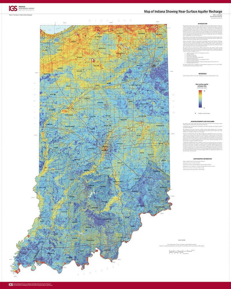
This groundwater-recharge map uses an objective, reproducible method to estimate diffuse groundwater recharge rates in Indiana, developed by conducting a multiple regression analysis to relate groundwater recharge to characteristics of near-surface geologic materials. The regression model was based on a conceptual model of diffuse groundwater recharge in humid temperate climates, which is controlled not only by near-surface processes such as climate but also by topographic position, the geology and land cover, and the position of the water table. In Indiana, the unsaturated thickness is not as great as it is in more arid environments, and so the depth to the water table and the characteristics of the unsaturated zone are important. The important variables were hypothesized to represent climate, topographic parameters that might describe preferential flow to the water table, soils and geologic characteristics of the ground surface (including land cover), and the unsaturated zone.
Letsinger, S. L., 2015, Map of Indiana showing near-surface aquifer recharge: Indiana Geological Survey Miscellaneous Map 92, scale 1:500,000.
You may also like:


Keywords: aquifers, recharge, groundwater, hydrogeology
Can't find what you're looking for? Feel free to contact us directly:
Indiana Geological and Water Survey
1001 E. 10th St.
Bloomington, IN 47405
812-855-7636 (phone)
812-855-2862 (fax)
IGWSinfo@indiana.edu
IGS Return Policy
- Original sales receipt required.
- Returns accepted within 30 days of purchase date.
- Refund will be issued by the same method of payment as purchased.
- Products must be returned in the same new condition as purchased.
- Refunds on custom orders and digital products are NOT allowed.
- Customers are responsible for paying shipping costs to return products.
Updated 8/19/2020