Because Indiana contains some Land Units that are not part of the Congressional Township and Range Survey System, they are not technically located within townships. The IGS uses Artificial Townships in these areas so that individual land units can be assigned an unofficial township and range designation.
The Artificial Township boundaries follow the outline of individual Land Units to prevent a single Land Unit from overlapping more than one township. This practice results in Artificial Township boundaries which do not follow straight lines, but rather zigzag as necessary. Well locations that fall within these Land Units are assigned to an Artificial Township. In practical usage, no distinction is made when referring to Congressional and Artificial Townships.
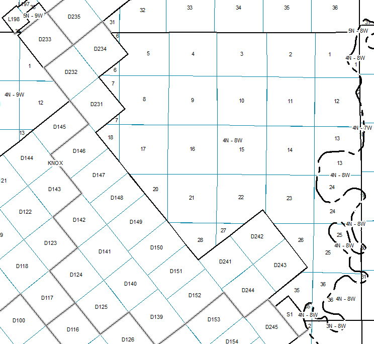
Example:
The map shows the Artificial Township 4N-8W and portions of surrounding townships, mostly located in Knox County. The Land Units in the diagonal northeast half of the township are primarily regular sections of the Congressional System. They are indicated by unmodified whole numbers on the map that do not exceed the value 36. The remaining Land Units on the map are Military Donations (prefixed by the letter D), Locations (prefixed by the letter L), and one Survey (prefixed by the letter S). Within the PDMS tables, prefixes are not used; rather, the Land Unit Type data field serves the same purpose.
Although Congressional Township 4N-8W proper includes only the combined area described by Sections (collectively outlined by solid black lines), the Artificial Township includes other Land Unit Types. An Artificial Township is made to be roughly the size of a normal Congressional township. Consequently, the grid of Indiana Townships (including Congressional and Artificial) does not contain any gaps, and the TR reference labels for Artificial Townships fall in logical sequence with the Congressional townships.
On the map, the boundary that defines Artificial Township is indicated by a fuzzy gray line.