

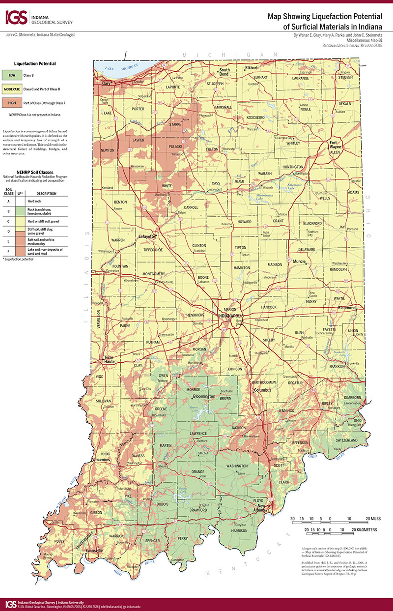
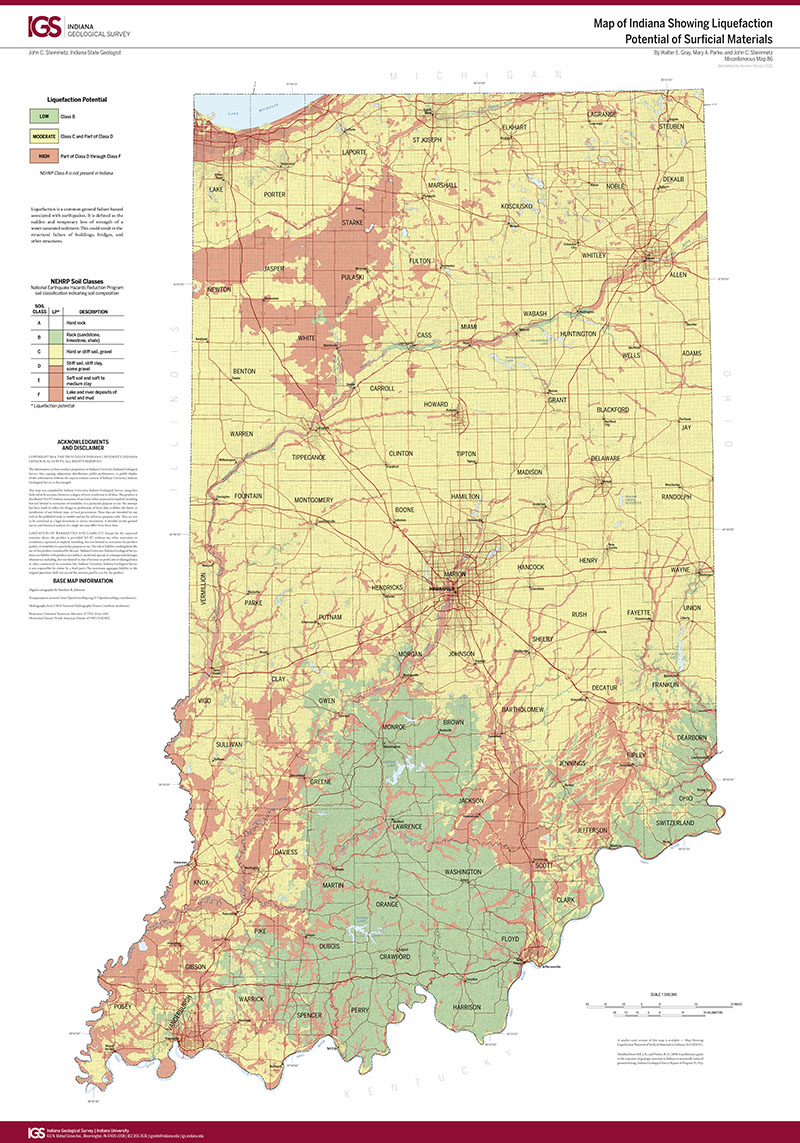
INTRODUCTION: Evansville has been the focus of our most intense study of soil velocity measures because of its vulnerability to earthquakes that originate in the New Madrid and Wabash Valley seismic zones. Thickness and particle size variations in the nonlithified unconsolidated sediments (soils) beneath the city determine the geographic distribution of damage from the future major earthquakes. Knowledge of shear-wave velocity, standard penetration testing (SPT), and cone penetrometer testing (CPT) of the unconsolidated sediment column is essential to determine soil period, amplification potential, liquefaction risk, and other site responses to earthquake shaking. Forty-four monitoring wells were installed to bedrock, penetrating from 23 to 140 ft of unconsolidated sediments, so that seismic velocities of soils could be measured in situ. Soil velocity testing was also completed on 21 private and public water monitoring wells. Sixty-four gamma ray logs were made on monitoring wells used in our study. More than 50 SPT's were made within Evansville and over six hundred SPT's records from public and private sources were collected. CPT's were conducted at 27 sites. This information was processed to evaluate how the cities "soils" will respond to earthquake shaking. From our downhole velocity measurements we were able to determine the dominant period at which soils would shake in response to an earthquake and the potential for the soil to amplify earthquake shaking. The data, particularly for SPT and CPT, were reviewed and evaluated to measure the risk of soil liquefaction within Evansville. Gamma logging is a technique that uses the natural radiation given off by sediments that surround a well to identify the particle size of the sediments. We applied this method to each well used in this report. Finer sediments, such as clay, generally emit more gamma radiation thus they sift the line to the right (higher gamma ray counts/sec.) And coarser sediments, sand and gravel, generally shift the line to the left (lower gamma ray counts/sec.). Soils in Evansville were deposited in a continuum of depositional settings from wind-blown loess (clayey silt), to lake deposits of clay and silt, and to stream deposits of silt, sand and gravel. Using the gamma logs of the monitoring wells, cross sections were made that show the lateral variations of soils within the city. These sectional views can be interpreted to show the underlying geological processes that determined the distribution of soils within the city, and they provide a framework for mapping seismic hazards within Evansville. Hopper (1985) prepared maps that suggested that some areas of Evansville would shake more severely than others and that some parts of the city are more vulnerable to soil liquefaction than others. Using the soil data we have collected in the Evansville region since 9189, we have made several new seismic hazard maps. These maps suggest that areas vulnerable to amplification of shaking or liquefaction are significantly different from those reported by Hopper. In response to our work, the United States Geological Survey has awarded two research contracts to build upon the information collected. These new studies will facilitate the development of the next generation of seismic hazard maps and maps that will help protect ground water.
Eggert, D. L., Samuelson, A. C., Bray, J. D., Chang, C. W., Eckhoff, W. R., Kayabali, K., McClees, E. J., West, T. R., Woodfield, M. C., Zheng, B. 1994, Final report to the City of Evansville: shear-wave and earthquake hazard mapping of Evansville, Indiana: Indiana Geological Survey Open-File Study 94-19, 17 p., 11 fig.
Notes: Publications in the Indiana Geological Survey Open-File series have been inconsistently named using a variety of series titles including "Open-File Report," "Open-File Map," and "Open-File Study." Prior to 1994, a publication in this series was generally referred to as an "Open-File Report" (but not always). To help reduce confusion created by these inconsistencies, the IGS now refers to every publication in the Open-File series as an "Open-File Study." To be entirely correct in writing a bibliographic reference for a publication, one should use the series name and number that appears on the publication itself.
1 app. (33 p.)
You may also like:
Keywords: earthquake, geologic hazard, soil velocity, New Madrid, shear-wave velocity, Wabash Valley, seismic, liquefaction, risk
Can't find what you're looking for? Feel free to contact us directly:
Indiana Geological and Water Survey
1001 E. 10th St.
Bloomington, IN 47405
812-855-7636 (phone)
812-855-2862 (fax)
IGWSinfo@indiana.edu
IGS Return Policy
- Original sales receipt required.
- Returns accepted within 30 days of purchase date.
- Refund will be issued by the same method of payment as purchased.
- Products must be returned in the same new condition as purchased.
- Refunds on custom orders and digital products are NOT allowed.
- Customers are responsible for paying shipping costs to return products.
Updated 8/19/2020