

Age:Mississippian Type designation:
Type section: The Spickert Knob Formation was named by Rexroad and Lane (1984) for exposures in Floyd County, Indiana, near Spickert Knob along Spickert Knob Road and adjacent gullies to the northeast (Rexroad, 1986). This is Stockdale's section 16 (1931, p. 115), which is in the NE¼ sec. 21 and SE¼ sec. 16, T. 2 S., R. 6 E., and extends a few tens of yards into sec. 22 (New Albany quadrangle) (Rexroad, 1986).
History of usage:The Spickert Knob is the precise equivalent of Stockdale's (1929) Locust Point and Carwood Formations, which in practice could not be separated as mappable units and which form a single depositional unit (Rexroad, 1986). Description:The Spickert Knob Formation consists of rocks between the New Providence Shale below and the Edwardsville Formation above (Rexroad, 1986). It is dominated by siltstone but includes abundant silty shale, some sandstone, and minor amounts of limestone (Rexroad, 1986). The formation tends to be more shaly and argillaceous in the lower part and to be dominated by massive siltstone in the upper part, but it is a complex of discontinuous lenses that were deposited as shifting and coalescing delta lobes and sublobes. Ironstone nodules and geodes are irregularly distributed in the formation (Rexroad, 1986).
Boundaries:Both boundaries are conformable and to some degree have intertonguing relationships (Rexroad, 1986). The formation represents delta-slope deposits (Rexroad, 1986). Correlations:The Spickert Knob Formation is approximately equivalent to the Nancy Member and the Holtsclaw Siltstone Member of the Borden Formation in north-central Kentucky (Rexroad, 1986). A variety of faunal elements (for example, brachiopods, crinoids, and cephalopods) in the formation have ranges that include or fall within the time-stratigraphic limits of the Keokuk Limestone of the Mississippi Valley (Kammer, Ausich, and Lane, 1983; Rexroad, 1986). Because the conodonts recovered from the New Providence Shale below (Rexroad and Scott, 1964) and the Floyds Knob Limestone Member of the Edwardsville Formation above (Gates and Rexroad, 1970; Whitehead, 1978) are of Keokuk-depositional age, the Spickert Knob, therefore, must also be equivalent to part of the Keokuk Limestone (Rexroad, 1986). |
|
Regional Indiana usage:
Illinois Basin Margin (COSUNA 12)
Misc/Abandoned Names:Carwood Formation, Locust Point Formation Geologic Map Unit Designation:Msk Note: Hansen (1991, p. 52) in Suggestions to authors of the reports of the United States Geological Survey noted that letter symbols for map units are considered to be unique to each geologic map and that adjacent maps do not necessarily need to use the same symbols for the same map unit. Therefore, map unit abbreviations in the Indiana Geologic Names Information System should be regarded simply as recommendations. |
COSUNA areas and regional terminologyNames for geologic units vary across Indiana. The Midwestern Basin and Arches Region COSUNA chart (Shaver, 1984) was developed to strategically document such variations in terminology. The geologic map (below left) is derived from this chart and provides an index to the five defined COSUNA regions in Indiana. The regions are generally based on regional bedrock outcrop patterns and major structural features in Indiana. (Click the maps below to view more detailed maps of COSUNA regions and major structural features in Indiana.) 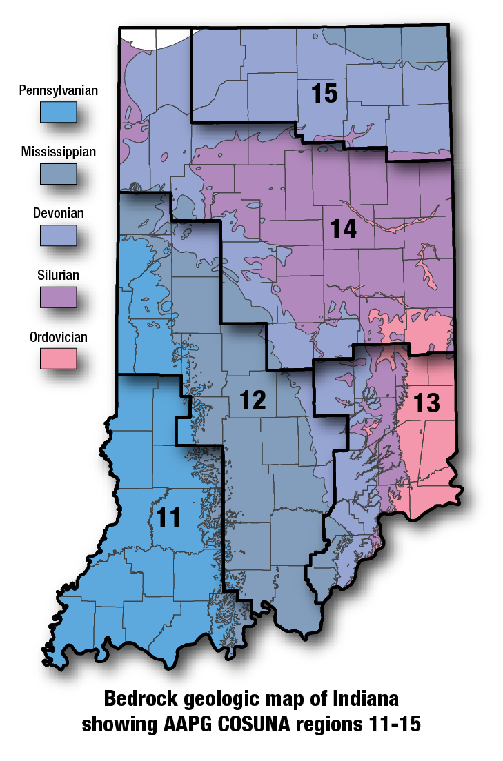
COSUNA areas and numbers that approximate regional bedrock outcrop patterns and major structural features in Indiana. 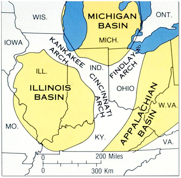
Major tectonic features that affect bedrock geology in Indiana. |
References:Hansen, W. R., 1991, Suggestions to authors of the reports of the United States Geological Survey (7th ed.): Washington, D.C., U.S. Geological Survey, 289 p. Hansen, W. R., 1991, Suggestions to authors of the reports of the United States Geological Survey (7th ed.): Washington, D.C., U.S. Geological Survey, 289 p. Shaver, R. H., coordinator, 1984, Midwestern basin and arches region–correlation of stratigraphic units in North America (COSUNA): American Association of Petroleum Geologists Correlation Chart Series. Shaver, R. H., coordinator, 1984, Midwestern basin and arches region–correlation of stratigraphic units in North America (COSUNA): American Association of Petroleum Geologists Correlation Chart Series. Stockdale, P. B., 1929, Facies of the Borden rocks of southern Indiana [abs.]: Ohio Journal of Science, v. 29, p. 170. Stockdale, P. B., 1929, Facies of the Borden rocks of southern Indiana [abs.]: Ohio Journal of Science, v. 29, p. 170. Stockdale, P. B., 1931, The Borden (Knobstone) rocks of southern Indiana: Indiana Department of Conservation Publication No. 98, 330 p. Stockdale, P. B., 1931, The Borden (Knobstone) rocks of southern Indiana: Indiana Department of Conservation Publication No. 98, 330 p. Whitehead, N. D., III, 1978, Lithostratigraphy, depositional environments, and conodont biostratigraphy of the Muldraugh Formation (Mississippian) in southern Indiana and north-central Kentucky: Southeastern Geology, v. 19, p. 83–109. Whitehead, N. D., III, 1978, Lithostratigraphy, depositional environments, and conodont biostratigraphy of the Muldraugh Formation (Mississippian) in southern Indiana and north-central Kentucky: Southeastern Geology, v. 19, p. 83–109. |
|
For additional information, contact:
Nancy Hasenmueller (hasenmue@indiana.edu)Date last revised: May 4, 2017