

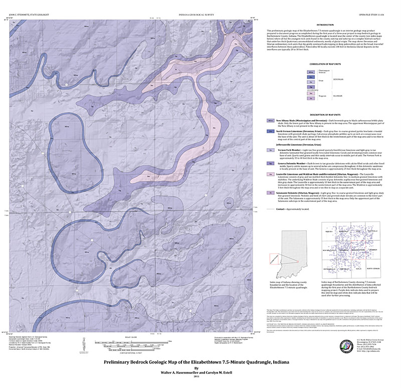
This work map shows the bedrock geology of the Elizabethtown 7.5-minute quadrangle at a scale of 1:24,000. The map consists of computer-generated outcrop and subcrop patterns of bedrock units. The map presents an interpretation of available public-domain geologic information useful to planners, educators, developers, and others interested in evaluating geologic conditions in the Elizabethtown area.
Hasenmueller, W. A., Estell, C. M. 2011, Preliminary bedrock geologic map of the Elizabethtown 7.5-minute quadrangle, Indiana: Indiana Geological Survey Open-File Study 11-04
You may also like:
Keywords: geologic map, bedrock map, STATEMAP
Can't find what you're looking for? Feel free to contact us directly:
Indiana Geological and Water Survey
1001 E. 10th St.
Bloomington, IN 47405
812-855-7636 (phone)
812-855-2862 (fax)
IGWSinfo@indiana.edu
IGS Return Policy
- Original sales receipt required.
- Returns accepted within 30 days of purchase date.
- Refund will be issued by the same method of payment as purchased.
- Products must be returned in the same new condition as purchased.
- Refunds on custom orders and digital products are NOT allowed.
- Customers are responsible for paying shipping costs to return products.
Updated 8/19/2020