

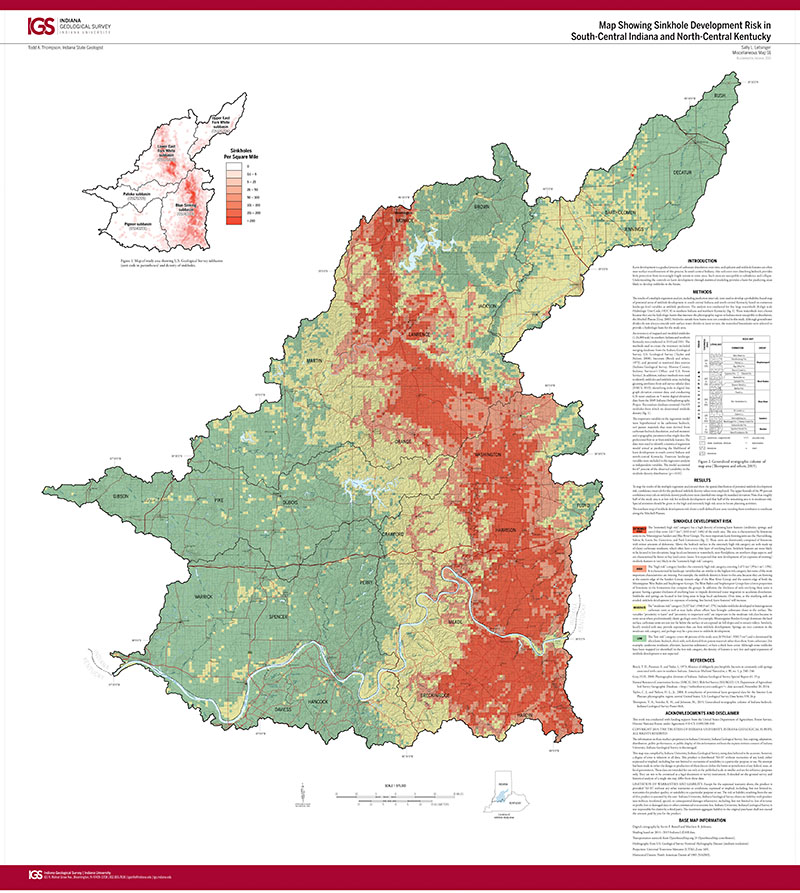
Karst development is a gradual process of carbonate dissolution over time, and epikarst and sinkhole features are often near-surface manifestations of this process. In south-central Indiana, thin soil cover over dissolving bedrock provides little protection from increasingly fragile terrain in some areas. Such areas are susceptible to subsidence and collapse. Understanding the controls on karst development through statistical modeling provides a basis for predicting areas likely to develop sinkholes in the future.
Letsinger, S. L., 2015, Map showing sinkhole development risk in south-central Indiana and north-central Kentucky: Indiana Geological Survey Miscellaneous Map 91, scale 1:375,000.
You may also like:

Keywords: karst, sinkholes, risk, hydrogeology
Can't find what you're looking for? Feel free to contact us directly:
Indiana Geological and Water Survey
1001 E. 10th St.
Bloomington, IN 47405
812-855-7636 (phone)
812-855-2862 (fax)
IGWSinfo@indiana.edu
IGS Return Policy
- Original sales receipt required.
- Returns accepted within 30 days of purchase date.
- Refund will be issued by the same method of payment as purchased.
- Products must be returned in the same new condition as purchased.
- Refunds on custom orders and digital products are NOT allowed.
- Customers are responsible for paying shipping costs to return products.
Updated 8/19/2020