

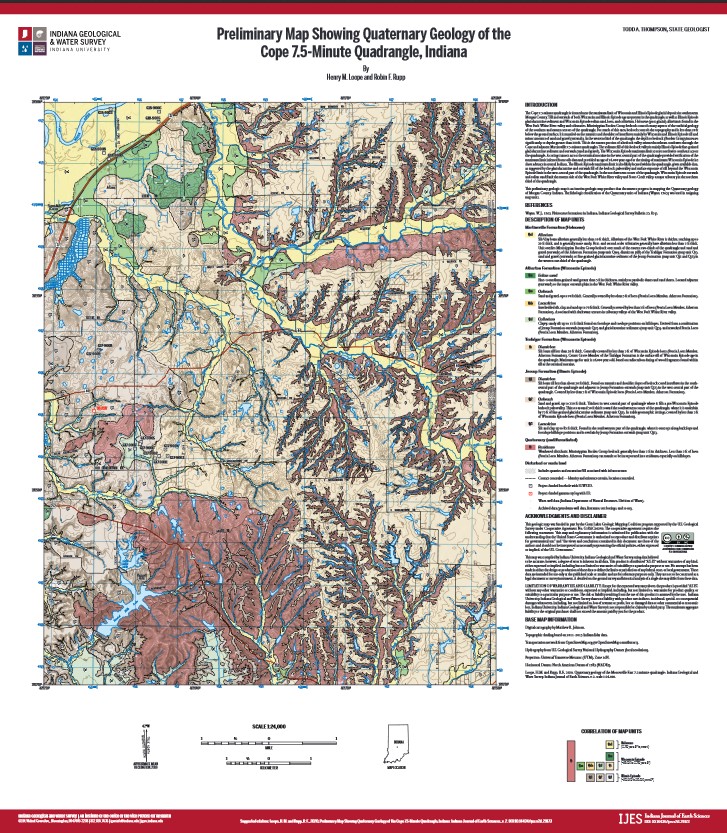
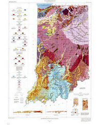
The Cope 7.5-minute quadrangle is situated near the maximum limit of Wisconsin and Illinois Episode glacial deposits in southeastern Morgan County. Till and outwash of both Wisconsin and Illinois Episode age are present in the quadrangle, as well as Illinois Episode glaciolacustrine sediment and Wisconsin Episode eolian sand, loess, and colluvium. Holocene (post-glacial) alluvium is found in the West Fork White River valley and tributaries. Mississippian Borden Group bedrock controls many aspects of the surficial geology of the southern and eastern sectors of the quadrangle. For much of this area, bedrock controls the topography and is less than 20 ft below the ground surface. It is mantled on the summits and shoulders of interfluves mainly by Wisconsin and Illinois Episode till and minor amounts of sand and gravel (outwash). In the western third of the quadrangle, the depth to bedrock (Borden Group) increases significantly, to depths greater than 200 ft. This is the eastern portion of a bedrock valley oriented northeast-southwest through the Cope and adjacent Martinsville 7.5-minute quadrangles. The sediment fill of this bedrock valley is mainly Illinois Episode fine-grained glaciolacustrine sediment and outwash (sand and gravel). The Wisconsin Episode maximum limit crosses northwest-southeast across the quadrangle. A coring transect across the terminal moraine in the west-central part of the quadrangle provided verification of the maximum limit inferred from soils data and provided an age of 24,000 years ago for the timing of maximum Wisconsin Episode ice sheet advance in central Indiana. The Illinois Episode maximum limit is also likely located within the quadrangle, given available data, as suggested by the glaciolacustrine and outwash fill of the bedrock paleovalley and surface exposure of till beyond the Wisconsin Episode limit in the west-central part of the quadrangle. In the northwestern corner of the quadrangle, Wisconsin Episode outwash and eolian sand flank the eastern side of the West Fork White River valley and Stotts Creek valley, a major tributary in the northern third of the quadrangle. This preliminary geologic map is an interim geologic map product that documents progress in mapping the Quaternary geology of Morgan County, Indiana. The lithologic classification of the Quaternary units of Indiana (Wayne, 1963) was used in assigning map units.
Loope, H. M., and Rupp, R. F., 2020, Preliminary map showing Quaternary geology of the Cope 7.5-minute quadrangle, Indiana: Indiana Geological and Water Survey, Indiana Journal of Earth Sciences, v. 2, scale 1:24,000. DOI 10.14434/ijes.v2i0.29173
You may also like:


Keywords: Morgan County, Indiana, Quaternary, geologic map, Cope quadrangle
Can't find what you're looking for? Feel free to contact us directly:
Indiana Geological and Water Survey
1001 E. 10th St.
Bloomington, IN 47405
812-855-7636 (phone)
812-855-2862 (fax)
IGWSinfo@indiana.edu
IGS Return Policy
- Original sales receipt required.
- Returns accepted within 30 days of purchase date.
- Refund will be issued by the same method of payment as purchased.
- Products must be returned in the same new condition as purchased.
- Refunds on custom orders and digital products are NOT allowed.
- Customers are responsible for paying shipping costs to return products.
Updated 8/19/2020