

Age:Cambrian Type designation:Type locality: In a provisional classification given by Walcott (1914, p. 354), the Mount Simon Sandstone was credited to a manuscript by E. O. Ulrich (Droste and Patton, 1986). General consensus indicates that the name is taken from an escarpment called Mount Simon near Eau Claire, Eau Claire County, Wisconsin (Droste and Patton, 1986). History of usage:In his original description Walcott described about 235 ft (72 m) of coarse-grained to conglomeratic sandstone overlying Precambrian granite and underlying fine-grained sandstone of the Eau Claire Formation (Droste and Patton, 1986).
Description:The Mount Simon Sandstone, the oldest known post-Precambrian unit in Indiana and the basal unit in the Potsdam Supergroup, is recognized only in the subsurface and was described in some detail by Becker, Hreha, and Dawson (1978) (Droste and Patton, 1986). It consists of poorly sorted fine-grained to very coarse grained sandstones that are generally poorly consolidated (Droste and Patton, 1986). A general color change occurs downward from white to yellowish gray to grayish red below (Droste and Patton, 1986). Gray and maroon shale is present throughout the formation in beds ranging from less than a foot to tens of feet in thickness, and another prominent shale zone, as thick as 60 ft (18 m), occurs in the upper part of the Mount Simon in northwestern Indiana (Droste and Patton, 1986; Medina and Rupp, 2012, fig. 5). A basal arkosic sandstone interval, as thick as 50 ft (15 m), is known from several wells that penetrate Precambrian rocks in Indiana (Becker, Hreha, and Dawson, 1978; Droste and Patton, 1986; Medina and Rupp, 2012) and in Illinois (Leetaru and McBride, 2009).
Correlations:The Mount Simon Sandstone is known by this name in Illinois, Wisconsin, Michigan, Ohio, and Kentucky and is the equivalent of the Lamotte Sandstone of Missouri (Droste and Shaver, 1983; Shaver, 1984; Droste and Patton, 1986; Medina and Rupp, 2012, fig. 2). |
|
Regional Indiana usage:
Illinois Basin (COSUNA 11)
Misc/Abandoned Names:None Geologic Map Unit Designation:Cms Note: Hansen (1991, p. 52) in Suggestions to authors of the reports of the United States Geological Survey noted that letter symbols for map units are considered to be unique to each geologic map and that adjacent maps do not necessarily need to use the same symbols for the same map unit. Therefore, map unit abbreviations in the Indiana Geologic Names Information System should be regarded simply as recommendations. |
COSUNA areas and regional terminologyNames for geologic units vary across Indiana. The Midwestern Basin and Arches Region COSUNA chart (Shaver, 1984) was developed to strategically document such variations in terminology. The geologic map (below left) is derived from this chart and provides an index to the five defined COSUNA regions in Indiana. The regions are generally based on regional bedrock outcrop patterns and major structural features in Indiana. (Click the maps below to view more detailed maps of COSUNA regions and major structural features in Indiana.) 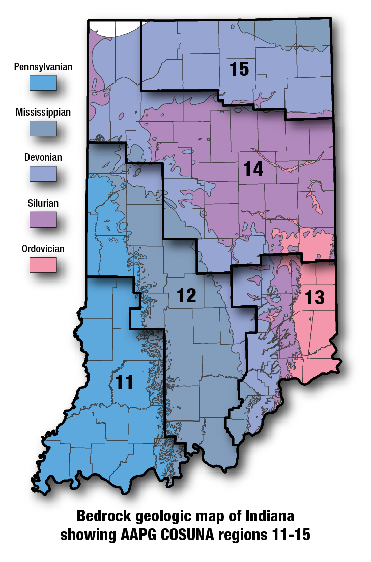
COSUNA areas and numbers that approximate regional bedrock outcrop patterns and major structural features in Indiana. 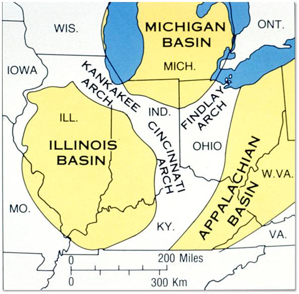
Major tectonic features that affect bedrock geology in Indiana. |
References:Hansen, W. R., 1991, Suggestions to authors of the reports of the United States Geological Survey (7th ed.): Washington, D.C., U.S. Geological Survey, 289 p. Hansen, W. R., 1991, Suggestions to authors of the reports of the United States Geological Survey (7th ed.): Washington, D.C., U.S. Geological Survey, 289 p. Leetaru, H. E., and McBride, J. H., 2009, Reservoir uncertainty, Precambrian topography, and carbon sequestration in the Mt. Simon Sandstone, Illinois Basin: Environmental Geosciences, v. 16, p. 235–243. Leetaru, H. E., and McBride, J. H., 2009, Reservoir uncertainty, Precambrian topography, and carbon sequestration in the Mt. Simon Sandstone, Illinois Basin: Environmental Geosciences, v. 16, p. 235–243. Medina, C. R., and Rupp, J. A., 2012, Reservoir characterization and lithostratigraphic division of the Mount Simon Sandstone (Cambrian): Implications for estimations of geologic sequestration storage capacity: Environmental Geosciences, v. 19, p. 1–15. Medina, C. R., and Rupp, J. A., 2012, Reservoir characterization and lithostratigraphic division of the Mount Simon Sandstone (Cambrian): Implications for estimations of geologic sequestration storage capacity: Environmental Geosciences, v. 19, p. 1–15. Medina, C. R., Rupp, J. A., and Barnes, D. A., 2011, Effects of reduction in porosity and permeability with depth on storage capacity and injectivity in deep saline aquifers: A case study from the Mount Simon Sandstone aquifer: International Journal of Greenhouse Gas Control, v. 5, p. 146–156. Medina, C. R., Rupp, J. A., and Barnes, D. A., 2011, Effects of reduction in porosity and permeability with depth on storage capacity and injectivity in deep saline aquifers: A case study from the Mount Simon Sandstone aquifer: International Journal of Greenhouse Gas Control, v. 5, p. 146–156. Shaver, R. H., coordinator, 1984, Midwestern basin and arches region–correlation of stratigraphic units in North America (COSUNA): American Association of Petroleum Geologists Correlation Chart Series. Shaver, R. H., coordinator, 1984, Midwestern basin and arches region–correlation of stratigraphic units in North America (COSUNA): American Association of Petroleum Geologists Correlation Chart Series. Walcott, C. D., 1914, Cambrian geology and paleontology: Smithsonian Miscellaneous Collections, v. 57, p. 345–412. Walcott, C. D., 1914, Cambrian geology and paleontology: Smithsonian Miscellaneous Collections, v. 57, p. 345–412. |
|
For additional information, contact:
Nancy Hasenmueller (hasenmue@indiana.edu)Date last revised: February 16, 2016